
The Ridge Historical Society
Louise Barwick – Part 6
By Carol Flynn
The Ridge Historical Society’s (RHS) current exhibit, “Louise Barwick’s Lost Ridge,” may be viewed on Sundays and Tuesdays from 1:00 p.m. to 4:00 p.m. or by appointment. RHS is located at 10621 S. Seeley Avenue in Chicago. The exhibit is free. RHS may be contacted at 773/881-1675 or ridgehistory@hotmail.com.
Louise Barwick (1871 – 1957) was a long-time resident and art teacher in the Ridge community. Her watercolor paintings of local scenes from around 1900, which form the basis of the current exhibit, offer a visual history of the environment of that time.
As was reported in the last post, however, it was actually Louise’s map-making skills that brought her recognition in her own time, and set her above the many genteel young women who engaged in painting as an “appropriate” pastime for a woman in those days.
A giant relief map of Illinois that was created by Louise was a main feature of the Illinois building at the 1893 World’s Fair in Chicago, also known as the Columbian Exposition.
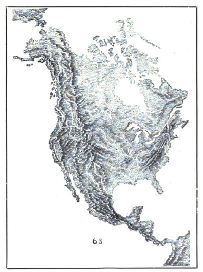
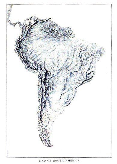
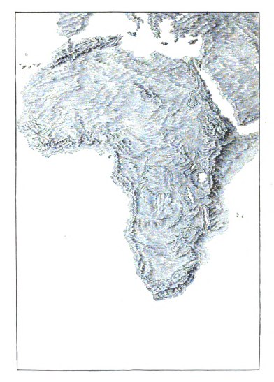
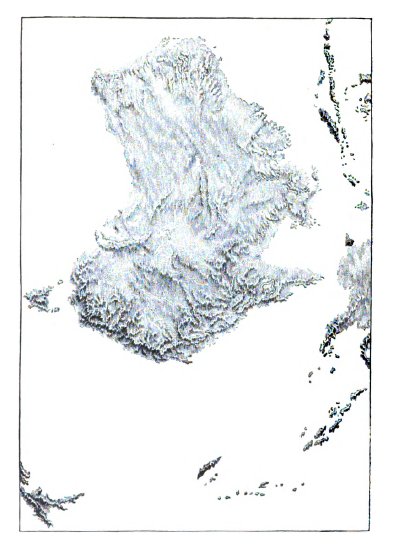
Louise was also known for her illustrations of maps in several publications.
She illustrated the relief maps for The Werner Introductory Geography, a textbook written by Horace S. Tarbell, the Superintendent of Schools of Providence, Rhode Island, published in 1896.
A review of this book in August 1896 in The Inland Educator, a publication labeled as “a journal for the progressive teacher,” stated that “the Werner geographies are a very substantial advance beyond the ordinary text-book along the line of ‘the new geography.’ Most of the stock fallacies which have been perpetuated by a long line of unscientific book makers are avoided.”
The review also states that the “illustrations and maps are well selected and executed” but notes that the elevations showed in the relief models were “exaggerated,” an “extreme now practiced by many model makers.”
In 1903, Ida Cassa Heffron, who was mentioned in the last post, published a book, Chalk Modeling – The New Method of Map Drawing.
Heffron, a Beverly resident whose father Rev. Daniel Salisbury Heffron helped found Bethany Union Church, was a lecturer and instructor in art at the Cook County Normal School and the University of Chicago, under Col. Francis Parker, the renowned education reformer.
Louise taught under Heffron at the Normal School. Louise created the maps of the continents in Heffron’s book on Chalk Modeling.
Heffron wrote in her introduction: “Acknowledgments are also due Miss Louise Barwick, for the zeal displayed in forwarding the development and delineation of the Maps of the Continents, and for valuable assistance rendered in the drawing of the same, as illustrations for this work.”
Next post: Louise Barwick’s teaching career on the Ridge.