
The Ridge Historical Society
Native Americans and the Blue Island Ridge – Part 14: Native American Sites Around the Blue Island Ridge
By Carol Flynn
This is a continuation of the series on the historical presence of Native Americans on and around the Blue Island ridge. The purpose of the series is not only to educate the community but also to help those organizations developing Land Acknowledgement Statements.
At the time white settlers arrived on the Ridge, the land was primarily being used by the Potawatomi people. The land had been used before that by other tribes – the Miami, the Illinois Confederation, the Sauk, the Fox, and the Kickapoo.
There were documented Native American sites around the Blue Island Ridge. There were also stories about Native Americans in the area in oral and written histories.
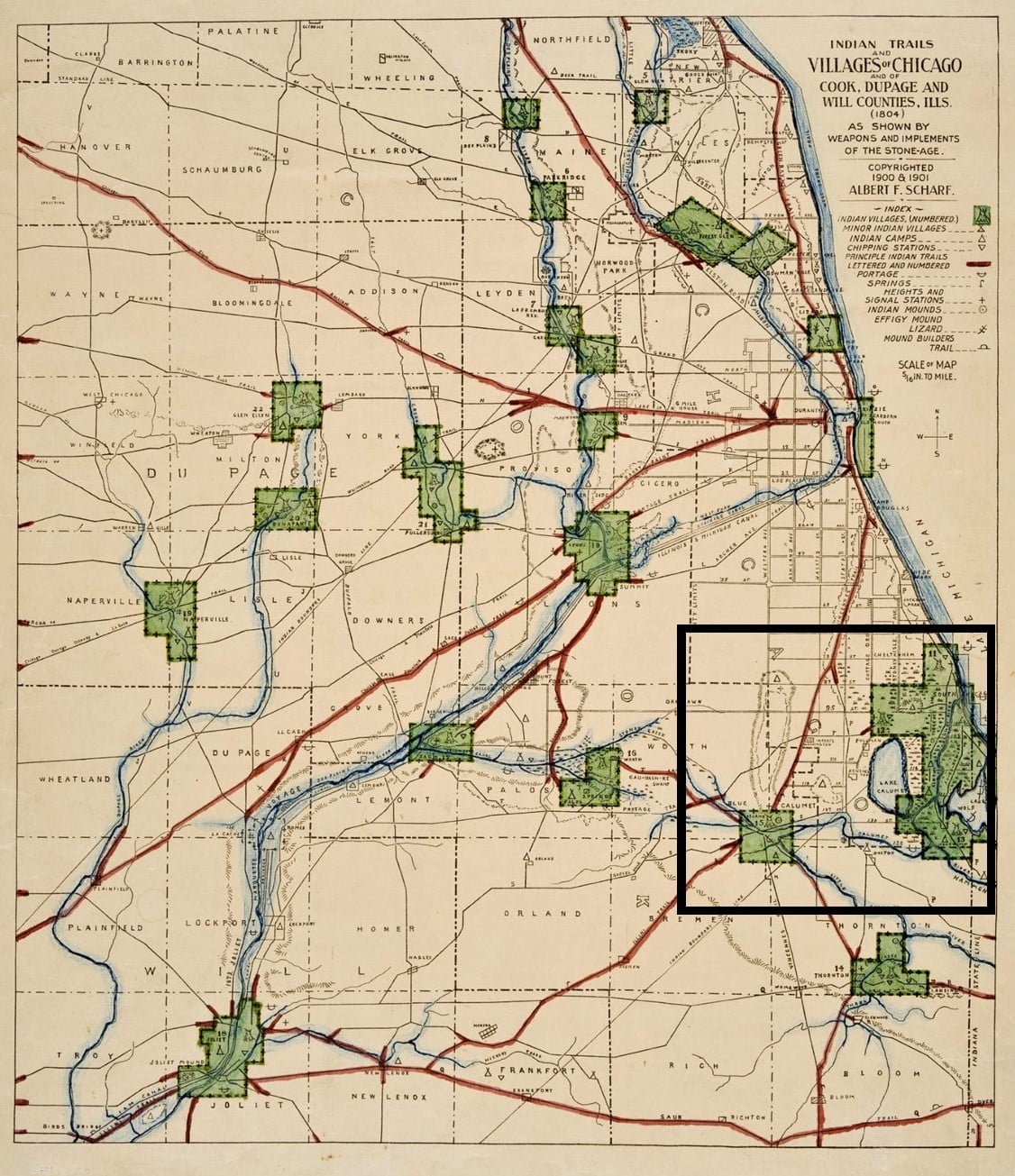
A map from 1804, reproduced and updated in 1900, shows the early Native American trails and villages of the Chicago area, and surrounding counties. Washington Heights and Blue Island are delineated, and the Blue Island is outlined.
On the full map, the Blue Island Ridge area is marked by the black square. The legend of the map shows the symbols. The vast wetlands between the Ridge area and Lake Michigan are evident on the map.
On the close-up of the map, the northern tip of the Ridge, roughly 87th Street and Western Avenue, is identified as number 1. This land is now included in the Dan Ryan Forest Preserve of the Forest Preserves District of Cook County (FPDCC). An Indian camp and signal station are shown there. The Ridge area is the highest elevation in Chicago, about 60 feet higher than downtown Chicago. From here, the surrounding territory could be observed for many miles around, all the way to “downtown” where Fort Dearborn stood, 12 miles to the northeast.
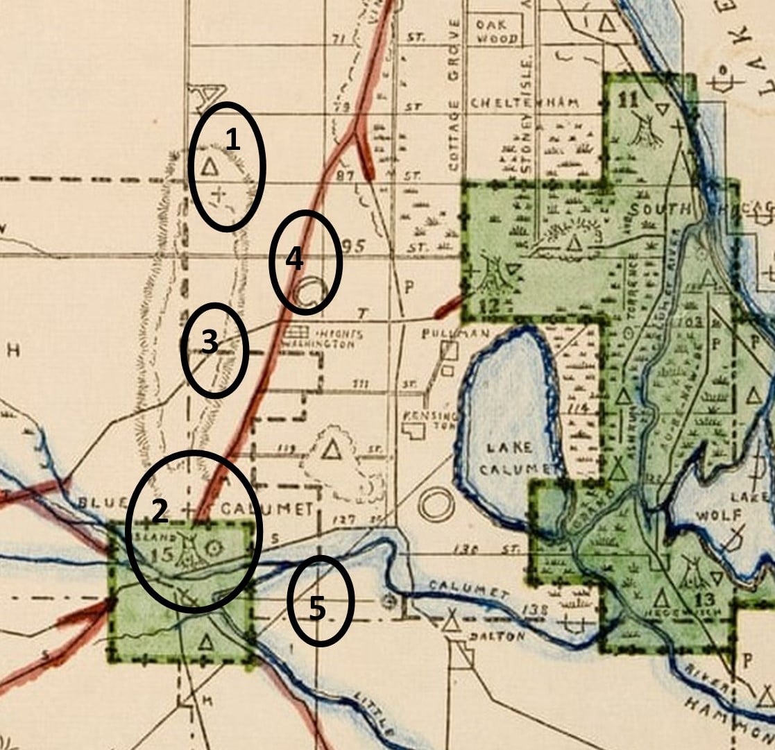
There are no other designations on this map for an Indian establishment on the top of the Ridge. There is some mention of an early map that includes the word “manitou” on the top of the Ridge. In general, because there are many Native American groups with varied beliefs, the Indigenous Peoples believed in a Great Creator, and they interacted with the Creator through spirits called manitous. Each individual had a personal manitou, and there were also manitous that resided in natural objects, such as the sun, trees, and rocks, that helped everyone. It would be consistent that a unique table of land like the Blue Island Ridge housed a manitou.
The southern end of the Blue Island is designated as number 2, where there was a major Indian village on the Stony Creek. The creek at that location is now part of the Cal-Sag Channel. There is also a circle that shows there was an Indian mound there, which likely was a burial site.
The mound builders were actually in the historic period before the Pottawatomi so this shows it was a Native American site for a long time. Another old document mentioned Native American “cemeteries” in Blue Island and to the east, but reported they “vanished” with time. Mounds in the Calumet region in Indiana were destroyed for farmland and this likely happened here also.
A portage trail is shown as number 3 on the map. This ran across the top of the Ridge, an overland route connecting the waterways to the east to the Stony Creek. It ran along what is now about 103rd Street. Portages were used to carry canoes overland where there were dry gaps between waterways.
The Vincennes Trail is marked by number 4. The Vincennes Trace or Trail, a major trail originally formed by migrating buffalo that was well known and used by Native Americans and later by European traders and settlers, ran through Kentucky and Indiana, and into Illinois. It was named the Vincennes Trail by white traders because a major location on the trail was Vincennes, Indiana, a city founded by French fur traders on land inhabited for thousands of years by Indigenous People.
In Illinois, the trail ran south of the Blue Island Ridge, and a branch split off, heading north/south to/from the area which became known as Chicago. Parts of the original trail became Chicago’s State Street and Vincennes Avenue.
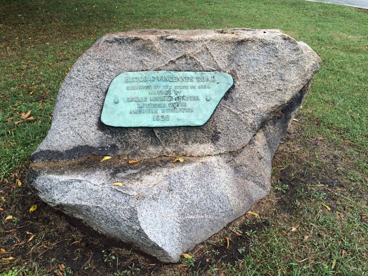
This branch that ran north/south to the Chicago area had two paths – one ran along the top of the Blue Island Ridge and a second path ran on the east side below the Ridge. A marker at 91st Street and South Pleasant Avenue indicates the original path, now lost, on top of the Ridge. The lower path eventually evolved into today’s Vincennes Avenue.
The southern Indian Boundary line mentioned previously, established in 1816, is number 5 on the map. There were two boundary lines – a north and a south one. The land in between the two lines defined the territory that could be used by settlers, and the land outside the boundary lines defined the territory that could be used by the Native Americans. The southern Indian Boundary Line was established running diagonally from the northeast to the southwest, passing just below the southern tip of the Ridge, thereby including the Ridge in the settlers’ territory. The land to the east and south of the line was for Native American use.
Next post: Other stories about the Native Americans on the Ridge.