
The Ridge Historical Society (RHS) will be open today, Sunday, Dec. 17, and Tuesday, Dec. 19, from 1 pm to 4 pm, for viewing the exhibit, "Louise Barwick's Lost Ridge." RHS is located at 10621 S. Seeley Avenue, Chicago. Admission is free. Parking is available on Seeley Avenue. RHS is not handicapped accessible.
One section of the exhibit is on KITE PHOTOGRAPHY
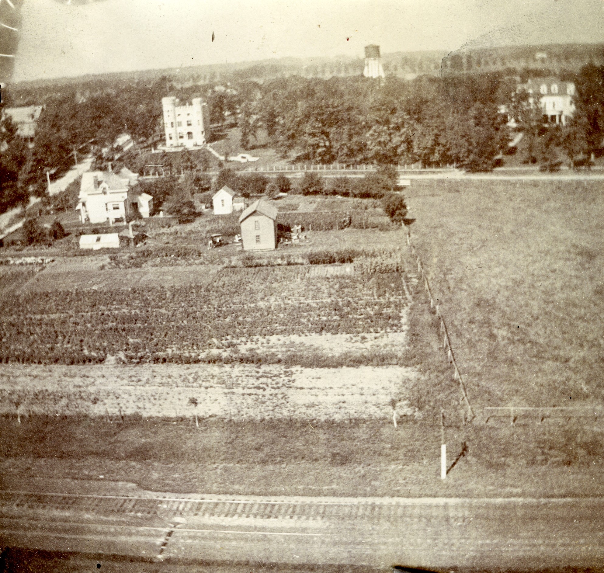
In 1899, two enterprising young men, Robert Heffron Murray and Frank Cox, attached a camera to a kite to take aerial photographs in the Beverly neighborhood. Murray, 17 years old at the time, and Cox, 21, both lived locally.
Fortunately, their experiments in aerial photography and their photos were reported in the local newspapers and therefore this historical record exists.
Several of the aerial photographs they published looked down on Longwood Drive at 103rd Street, giving us, literally, images frozen in time that document the corner as it existed almost 125 years ago.
This photo is one of them, and was posted a few days ago, inviting viewers to identify the location and buildings, which they readily did. Today is a follow up, with more information on the photo.
At the time, this area was known as “Tracy.” It was part of Washington Heights, which had annexed to the City of Chicago in 1890.
The name “Beverly Hills” was being used for a section in what is now North Beverly, around 91st Street, but it would not be until the 1910s that the name became commonly used for the entire section we know as Beverly today.
This photograph was taken from a field around today’s 102nd and Wood Streets. It is facing west, and shows in the foreground the train tracks of the Chicago, Rock Island, and Pacific line, which is today’s Metra Rock Island line.
Easily identified in the upper left is the Robert C. Givins House, also known as the Givins Castle, built in 1886-87, still prominent today as an area landmark. For orientation, this is the northwest corner of 103rd Street and Longwood Drive.
East of the Castle, where today there is a CVS Pharmacy on the northeast corner, is the Barnard seed farm. The Barnards were very early settlers in the area, and they grew primarily flowers on their farm which they harvested for their seeds and sold on the retail market.
To the north of the Castle (right side of photo), the large white house is the Horace E. Horton House, 10200 S. Longwood Drive, built in 1890 for the founder of the Chicago Bridge & Iron Company. The house is still there today. The rest of the block is still wooded territory. Incidentally, in 1905, Robert Heffron Murray married Sue Mary Horton, Horace’s daughter.
In the upper middle background is the Washington Heights water tower, which was located between Hoyne and Seeley Avenues. The water tower has an interesting history of its own. Before being annexed to the city, Washington Heights had its own water supply drawn from artesian wells. After annexation to the city, the water was drawn from Lake Michigan from a main at the Hyde Park pumping station at 68th Street. The water was pumped to storage reservoirs. The Blue Island Ridge, being of a higher elevation, had a separate water supply system and an additional pumping station at 104th and Charles Street, which brought the water up to this tank, which also had a small pumping station.
Eventually, technology advances did away with the need for this additional system, but the remains of the buildings were evident in the backyards of homes along Seeley and Hoyne for years.
For more information on this “kite photography experiment” visit the RHS exhibit. There were other photos taken with different views of the area that are explored in the exhibit.