
The Ridge Historical Society
Louise Barwick – Part 5
By Carol Flynn
The Ridge Historical Society’s (RHS) current exhibit, “Louise Barwick’s Lost Ridge,” may be viewed on Sundays and Tuesdays from 1:00 p.m. to 4:00 p.m. or by appointment. RHS is located at 10621 S. Seeley Avenue in Chicago. The exhibit is free. RHS may be contacted at 773/881-1675 or ridgehistory@hotmail.com.
Louise Barwick (1871 – 1957) was a long-time resident and art teacher in the Ridge community. Her watercolor paintings of local scenes from around 1900, which form the basis of the current exhibit, offer a visual history of the environment of that time.
However, it was actually Louise’s map-making skills that brought her recognition in her own time, and set her above the many genteel young women who engaged in painting as an “appropriate” pastime for a woman in those days.
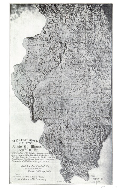
Louise Barwick’s work was one of the prize features of the Illinois building at the 1893 World’s Fair in Chicago, also known as the Columbian Exposition. She created and displayed a relief map of the State of Illinois, showing the topographical features of the state, such as the rivers, valleys, and geographic formations, as well as the counties, major cities, and railroads. The map was a huge 10 feet by 17 feet and made of plaster.
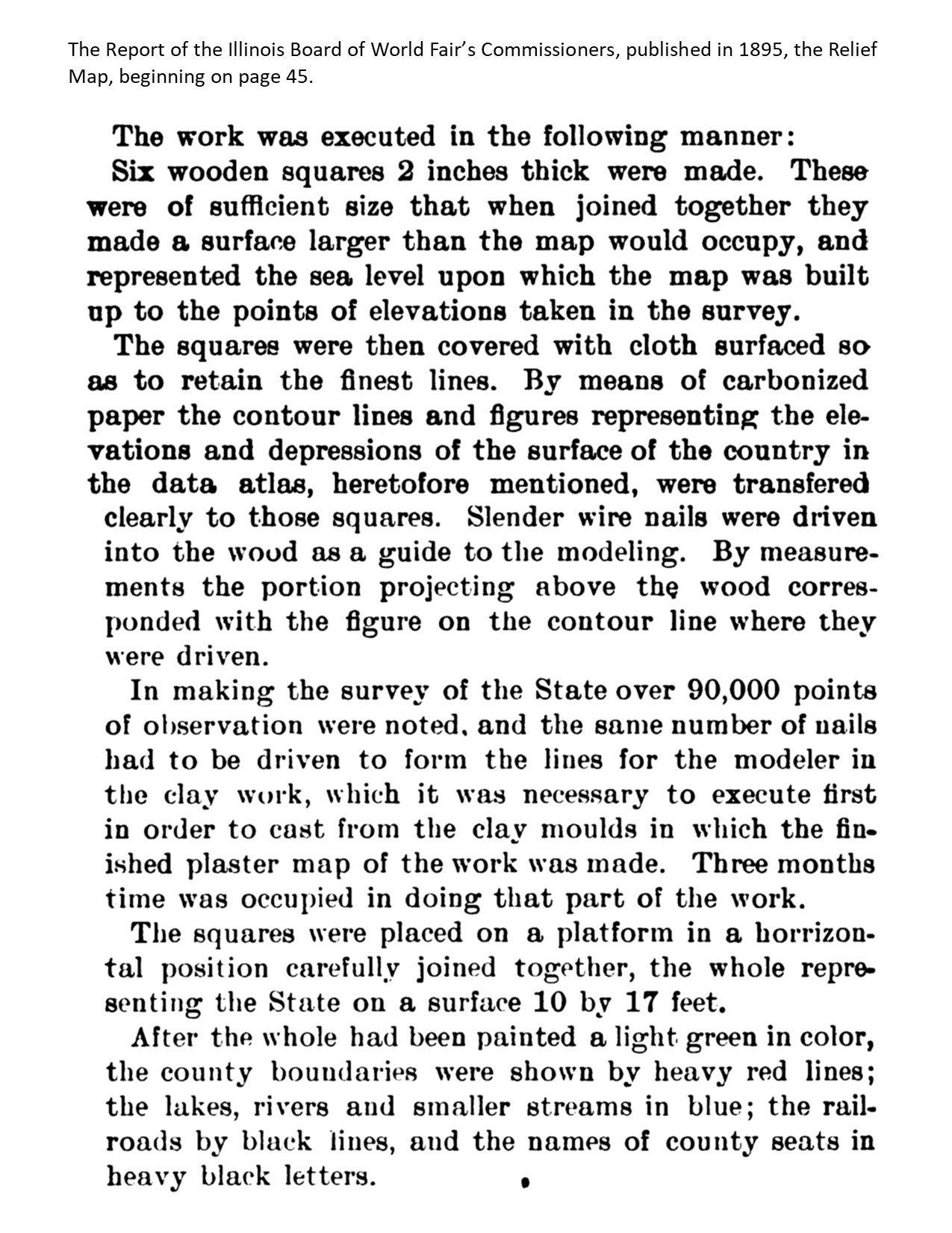
The Report of the Illinois Board of World Fair’s Commissioners, published in 1895, who proposed the map, covered the project in great detail. It was based on surveys overseen by C. W. Rolfe, professor of geology at the U. of Illinois – Urbana.
Then “Miss Louise Barwick of Tracy, Cook County, Illinois, a skilled artist in modeling work, was engaged to model the work in clay preparatory to making the plaster cast.”
Ten more pages of the report, which can be found through this link, explain the content of the map, based on the academic knowledge of the day. https://www.google.com/books/edition/Report_of_the_Illinois_Board_of_World_s/1IYPAAAAYAAJ?hl=en&gbpv=1&dq=The+Report+of+the+Illinois+Board+of+World+Fair%E2%80%99s+Commissioners&printsec=frontcover
Louise and her father received payment of $850 for this work, according to the financial records of the Board. There was no break-down for this amount so whether it was for supplies or as revenue was not clear.
The Board made many positive comments about the map. No topographical survey of Illinois had ever been made before, and no other state had made a relief map in the form of this one from actual survey of its surface.
The Board report stated: “The whole, when completed, making a graphic birdseye view of the State, the like of which no human eye had ever seen before. As an exhibit it was one of the most interesting in the building. It was daily surrounded by the aged and the youthful visitor, who seemed greatly impressed as they gazed on the face of our great State. Teachers, students and children engaged in the primary grades of education, seemed alike deeply interested in studying it…. The map teaches many more object lessons to the student of geography of our State, and if one could be placed in every school of the State the value to the cause of education in that one study cannot be estimated.”
The map wound up in the Illinois State Museum, but unfortunately, has been lost to time. RHS contacted the Museum to learn if the map still existed, but was informed that it was no longer in the collection. Museum staff assumed that the map likely disintegrated over time or was lost in a fire.
Louise Barwick became known as a skilled artist in modeling work. More of her maps will be discussed in the next post.