
Explore the RHS Facebook Archives, a rich repository of local history written by Carol Flynn. For two decades, Carol brought a deeply dedicated voice to public education at RHS. Her role as Facebook administrator through mid-2025 naturally extended her prolific research into meticulously detailed articles, most notably her multi-part historical series posts. Today, Carol continues her local history writing for The Beverly Review and other outlets.
History of the Chicago Wards
History of the WardsWhy Beverly and Morgan Park Are “Dry”
This week’s Beverly Review includes the seventh installment of the series about the history of the Chicago wards in the Ridge communities. This installment looks at the 1930s and 1940s.
One of the issues that the U.S. dealt with in the 1930s was the end of Prohibition. The consumption of alcohol was never illegal. The Eighteenth Amendment to the U.S. Constitution, which went into effect in 1920, prohibited the manufacture, transportation, and sale of alcoholic beverages. This Amendment was repealed in December 1933 with the ratification of the Twenty-first Amendment.
While most of Chicago took the end of Prohibition in stride, it became a major issue on the Ridge. Decisions made by the community beginning in 1934 have kept Beverly and Morgan Park “dry” east of Western Avenue since that time.
Sections of the Ridge communities were dry before Prohibition began, of course. Morgan Park was intentionally founded in the 1870s as a religious, educational, and temperance community, and the Protestant ministers of the community led the way with the temperance movement even years before that.
When Prohibition began in 1920, every locale officially went dry. When Prohibition ended in 1933, every locale officially became “wet.” Saloons opened all over the country, including on the east side of Western Avenue and along 95th Street.
The new Illinois Liquor Control Act of 1934, however, provided that election precincts could vote by referendum to stay “dry.”
A campaign was undertaken in Beverly/Morgan Park to vote dry the precincts bounded by 89th Street, Western Avenue, 119th Street, and the Rock Island Railroad tracks. Members of a Ridge civic association went door-to-door, precinct-by-precinct, to collect petition signatures for a referendum and to obtain promises of votes when the referendum was held. The campaign was successful, and additional precincts in the ward also voted to stay dry.
The nineteenth ward became the driest ward in the city. The newspapers referred to it as “bone-dry Beverly.” The saloons that had opened on the east side of Western Avenue and on 95th Street all had to close.
In 1946, a referendum was held to make the precincts between Western Avenue, 99th Street, California Avenue, and 119th Street dry. This included the west side of Western Avenue. The proposal was defeated, paving the way for the bars, breweries, and restaurants that are found along that strip now.
Since that time, there have been campaigns to allow the sale of alcohol east of Western Avenue, but they have been voted down consistently by the community. The decision is made by the registered voters within the precinct, not by the alderman or the
city or any civic group.
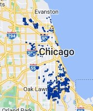
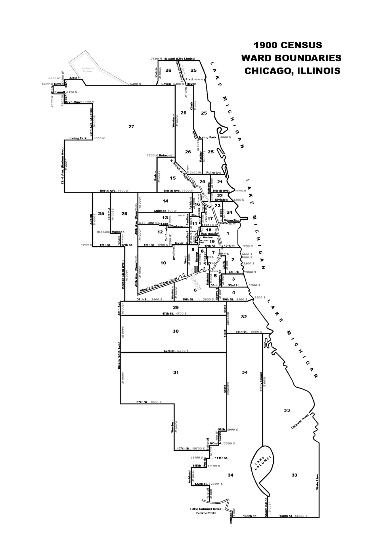
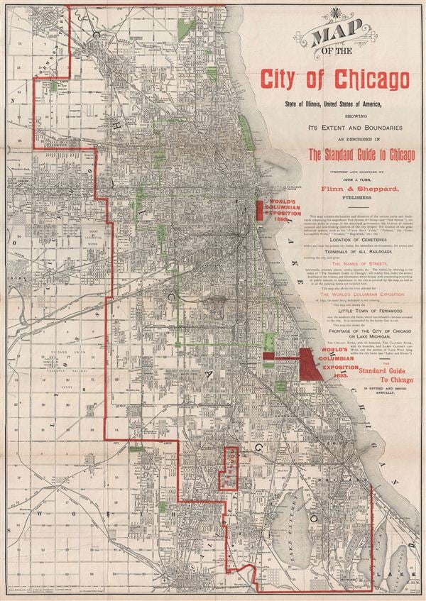
This map shows the dry precincts in the City of Chicago. Note the concentration in the far southwest area – a good-sized portion of the nineteenth ward.
https://www.beverlyreview.net/news/community_news/article_e56364d2-1283-11ed-b3b7-b38813422447.html
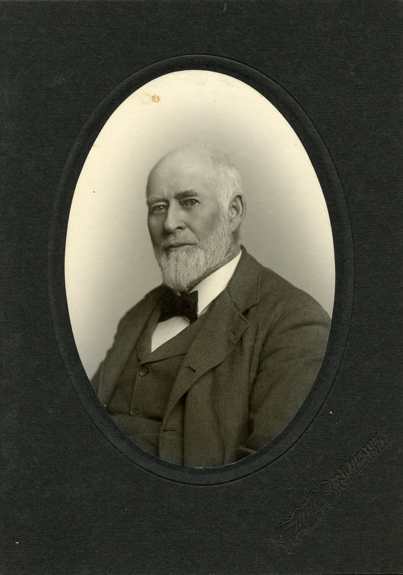
History of the Chicago Wards – Post 7Isaiah T. Greenacre
Washington Heights, which included the land from Western Avenue east between 95th Street and 107th Street (today’s Beverly), and the unincorporated land north of 95th Street to 87th Street (today’s North Beverly), were annexed to the city of Chicago in 1890, and became part of the 31st ward in 1891.
Isaiah Thomas Greenacre was the first man who lived in Washington Heights to be elected to serve as alderman for the 31st ward. He served for one term, from 1895 to 1897.
It’s appropriate to take a detour from exploring the history of the wards on the Ridge to take a look at Greenacre. He grew up in the community and became thoroughly immersed in its workings. There were likely few people who knew more about the community than he did.
Being an alderman was just one brief accomplishment for Greenacre. This man, a product of this community, had a lasting impact on the entire country.
Isaiah Thomas Greenacre was born in 1863 in Illinois. His father was Isaiah Greenacre and his mother was Lucinda Young Greenacre. The son always went by Isaiah T. or I. T. Greenacre.
The original Isaiah Greenacre, the father, was born in England in 1828 and came to the U.S. in 1852. He and Lucinda Young from Kilkenny, Ireland, born in 1831, married in New York in 1853, and moved to Chicago. On the 1860 U.S. Census, they were listed as living in Chicago ward six, which was centered around Van Buren and Jefferson Streets. Greenacre’s occupation was given as carpenter.
The birth of one child, Isaiah Thomas, was recorded, in Will County in 1863.
On the 1870 U.S. Census, the family is reported as living in Chicago ward 15, which was north of Chicago Avenue and west of the Chicago River. Greenacre also shows up on the census that year in Escanaba, Michigan, living with other carpenters and engineers with the Bushnell family, owners of a “brandy house.” He was perhaps there on a job.
By 1874, the family had moved to the southside closer to the Ridge. That year, the residents voted to incorporate as the Village of Washington Heights, and Greenacre was elected as a member of the Board of Trustees. The area was experiencing substantial growth as people left the city for the suburbs after the Great Chicago Fire in 1871, and the railroads made the area more accessible.
Greenacre usually served as president pro tem of the Board when the president, the Rev. D.S. Heffron of the Bethany Union Church, could not be in attendance. The trustees dealt with all aspects of the new, growing village, including installing sewers and sidewalks; grading and graveling streets; approving new developments; building schools; establishing a police force; determining assessments for improvements; and appropriating funds for salaries and other expenses. One line item was for $150 for the “village calaboose,” the jail.
Issues with the railroads that ran through the area were dealt with, such as removing old tracks so streets could be extended, and cleaning out and covering a well on railroad property and turning it over to the village for use by the residents.
Everyday life was the business of the Board of Trustees. Liquor licenses were granted in the beginning years of the village and there were saloons to regulate. Other issues included everything from the benign such as strawberry festivals at local churches, and residents securing their cows so they did not wander the village streets, to the more sinister such as an increase in home burglaries. Dealing with the throngs of people who came to the community by train on Sundays to picnic and party in the scenic wooded groves of the Ridge was a constant challenge. There were disturbing occurrences, including the accidental shooting and killing of a woman during one July 4th revelry in the local woods.
This was the world in which Isaiah T. Greenacre grew up. By 1884 at the age of 21, he was already involved in politics and practicing law.
The Greenacre parents moved to California in 1892. Isaiah died in 1897, and Lucinda in 1901. Their remains were returned to Chicago for burial in Mount Hope Cemetery on 115th Street.
Next post: The life and career of Isaiah T. Greenacre.
History of the Chicago Wards – Post 6Beginning a Chicago Wards Timeline for the Ridge; Early Aldermen for the Ridge
A timeline has been started for the history of the Chicago wards on the Ridge.
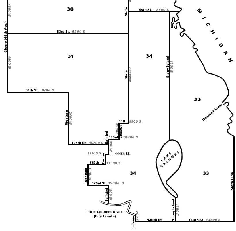
1889, June – Lake Township was annexed to the City of Chicago, which included the land north of 87th Street, east of Western Avenue, which today includes the northern part of Dan Ryan Woods. This land includes the northern tip of the Blue Island Ridge so the land is connected geographically to the Ridge even though it is not considered part of North Beverly and is not part of today’s 19th ward. At the time of annexation, the land was part of the Sherman Farm estate. This land formed part of the new 31st ward.
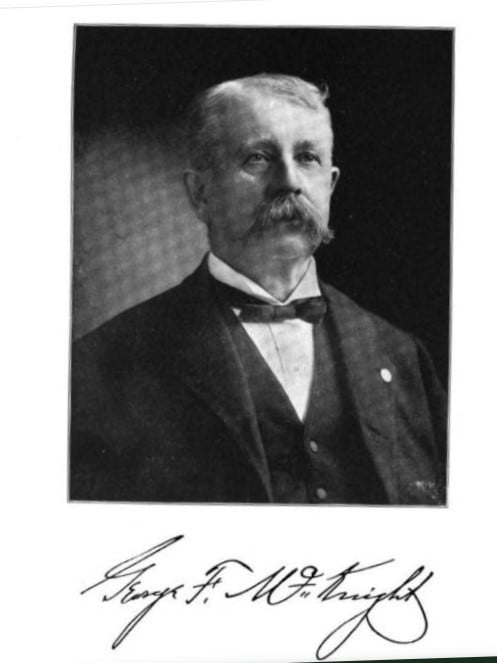
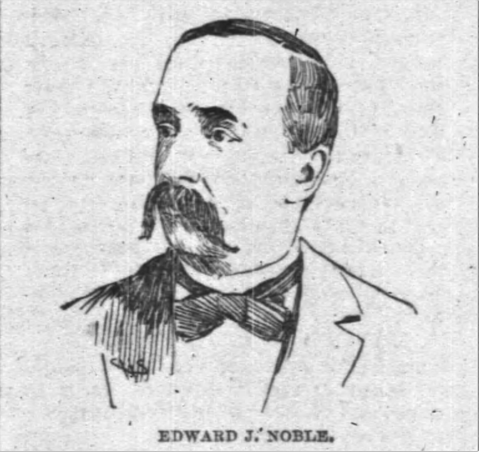
The first two aldermen for any part of the Ridge were Edwin J. Noble and Captain George F. McKnight, Republicans from the thirty-first ward.
1890, April – The land from 87th Street south to 95th Street, Western Avenue east to State Street, included in the Calumet Township, was annexed. It had been unincorporated land before that. The land included what today is known as North Beverly. It was assigned to the 31st ward.
1890, November – The land from 95th Street south to 107th Street, Western Avenue east to a zigzag alignment of streets, was annexed. The municipality had been incorporated as Washington Heights, and included today’s Beverly Hills.
1891, February – The annexed land of Washington Heights was added to the 31st ward.
1895, April – Isaiah T. Greenacre was elected the first alderman from the Ridge.
North Beverly and Washington Heights remained in the 31st ward until 1901, when population growth and shifts led to redistricting of the wards. The part of the 31st ward that included North Beverly and Washington Heights was split off into its own ward, and the renumbering of the city wards made this the 32nd ward. This will be covered in an upcoming post.
The aldermen of the 31st ward during the time it included North Beverly and Washington Heights, all Republican, were:
1889-1891: George McKnight
1889-1896: Edwin Noble
1891-1893: Edwin A. Plowman
1893-1895: James L. Francis
1895-1897: Isaiah T. Greenacre
1896-1898: Clark T. Northrop
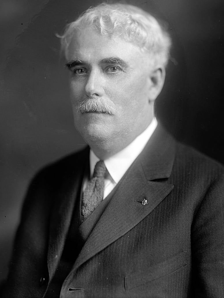
1897-1899: Elliot W. Sproul
1898-1901: Joseph Badenoch
1899-1901: Henry F. Eidmann
McKnight, Noble and Plowman were covered in previous posts.
Francis was a prominent member of the city council’s special committee for the 1893 World’s Fair. He planned on seeking reelection in 1895 but he was ousted by the Republican “machine.” Later that year, Francis was charged with “boodling,” the term for various types of graft and corruption. He was accused of accepting cash and stock from the Mutual Electric Light and Power Company, located in Brainerd, in exchange for backing ordinances favorable to the company, charges he strongly denied.
Isaiah T. Greenacre was the first alderman elected from the Ridge. He played a considerable role in local, city, and state politics and he will be profiled in the next post.
Northrup was a prominent businessman who held the position of foreign representative with Smith and Co. before becoming a member of the Board of Trade. He had been a trustee for Lake Township.
Sproul was a contractor and builder. He later served in the U.S. House of Representatives as the Congressman from the 3rd District of Illinois from 1921 to 1931. This photo is of Elliot W. Sproul.
Next post: Isaiah T. Greenacre, first alderman elected from the Ridge.
History of the Chicago Wards – Post 5Washington Heights Joins the Chicago Ward Structure
In November of 1890, the annexation of the Village of Washington Heights to the City of Chicago became official. At the same time, the Village of West Roseland to the southeast of Washington Heights was also annexed.
The next step was for the Chicago city council to pass an ordinance approving the annexation and adding the land to the ward system.
In 1889, with the annexation of 125 square miles of land into the city, the wards had been reconfigured and new ones created. The total number of wards had increased from twenty-four to thirty-four. When the area now known as North Beverly between 87th Street and 95th Street was annexed earlier in 1890, it was added to the thirty-first ward.
The determination of wards and their boundaries was a constant battle between the Democrats and Republicans on the city council to influence the election of aldermen according to political party affiliation. In 1890, Mayor DeWitt Clinton Cregier and the majority of the city council were Democrats, but that had gone back and forth through the early history of the city.
By 1890, Cregier was the fifteenth Democratic mayor. There had been five Whig mayors, and after this party merged to create the Republican Party in the 1850s, nine more Republican mayors. There had been five mayors with other or no political party affiliations.
It was generally assumed that Washington Heights would become its own ward – the thirty-fifth ward – when it was annexed. This new ward might also include West Roseland, or that area would be incorporated into an existing ward.
However, Washington Heights was strongly Republican, and establishing it as a new ward would almost certainly result in the election of two new Republican aldermen, something the Democrats did not want. Mayor Cregier was in favor of adding Washington Heights and West Roseland to existing wards.
An ordinance was drafted calling for the creation of a new ward for Washington Heights, and submitted to the Judiciary Committee of the city council. At the same time, two other ordinances were also submitted, calling for Washington Heights to be assigned to the thirty-first ward, and West Roseland to the thirty-fourth ward.
Establishing the new ward was a contentious issue in the city council. One alderman was quoted as saying about the ordinance before the Judiciary Committee, “It will sleep the sleep that knows no waking.” This proved so. That ordinance died in committee, and the ordinances to assign the areas to existing wards were presented to the city council, and approved.
Washington Heights became part of the thirty-first ward on February 25, 1891. West Roseland became part of the thirty-fourth ward.
Election precincts had already been established in the interim. In addition to the regularly scheduled voter registration day for the entire city, a second day was arranged for the new Chicago residents to register to vote. The annual aldermanic election was scheduled for the first Tuesday in April.
The two aldermen of the thirty-first ward were Captain George F. McKnight and Edwin J. Noble. Both had just been elected the previous year when the ward was established. Both were Republicans and ran unopposed.
As reported in Post 4, Noble was a grain merchant and stock trader on the Chicago Board of Trade. McKnight had a wide background in business and founded the Lake Gas Company in Chicago.
On the city council, Noble was a member of the Licenses, Streets and Alleys South, and Elections committees. McKnight sat on the Wharfing Privileges, Local Assessments, and Health and County Relations committees.
Each new ward had elected two aldermen in 1890, and to fit the positions into the election cycle, one was elected for a two-year term, and the other for a one-year term. McKnight was elected for one-year, so he was up for re-election in 1891, but he decided not to run for a second term.
The first election as residents of Chicago that the Washington Heights/Beverly voters participated in was to elect a new alderman to replace McKnight. The regular Republican “machine,” and that term was used back then for both parties, nominated Edwin A. Plowman for the position. Plowman was chief of the abstracts department of the Cook County Recorder’s office. He had sought the alderman position in 1889 but lost the nomination to McKnight.
However, a faction of Republicans in the ward nominated A. C. Clarke, an insurance adjustor, known for taking stances that differed from the official Republican stances. Clarke insisted he was the official nominee from the Republican Party. Despite some very heated debates, the Republican party leadership prevailed, and Plowman was listed on the ballot as the Republican candidate. Clarke ran as an Independent. They were joined on the ballot by nominees from the Democratic and Socialist parties.
Plowman won the election, becoming the new alderman for the thirty-first ward, and he served for one term. The position of mayor was also on the ballot that year, and Cregier lost to the Republican candidate Hempstead Washburne.
Noble was elected several more times, and served as alderman for the thirty-first ward until 1896.
Next: The Thirty-first Ward up to 1914
History of the Chicago Wards – Post 4 REVISEDNorth Beverly Joins the Chicago Ward Structure
In 1890, three parcels of land were annexed to the City of Chicago, forever changing the Ridge communities.
First, the unincorporated area between 87th Street and 95th Street, and between State Street and Western Avenue, which includes today’s North Beverly, was annexed.
This annexation included local communities whose names were on the stops along the Rock Island railroad line (now the Metra line) – Beverly Hills (91st Street) and Longwood (95th Street). Also included was a section of Englewood and the Brainerd neighborhood to the east. These communities were identified as “flourishing new suburbs” by the Chicago Tribune.
A new state law passed in 1889 allowed for incorporated areas and the cities with which they wanted to annex to hold elections on the issue. However, unincorporated areas still fell under the jurisdiction of the previous law referred to as the “James P. Root annexation law,” which allowed areas to annex by petitioning the city. A petition had to be signed by three-fourths of the legal voters and property owners representing two-thirds of the community’s value.
The voters and property owners of Beverly Hills,
Longwood, and the communities to the east, petitioned the Chicago city council to annex this territory, and the Judiciary Committee signed off on this petition, in April 1890. The city council then passed an ordinance to make the annexation official in May of 1890.
The Chicago city council assigned this land to the existing thirty-first ward, which had just been established the year before when 125 square miles of land was added to the city. The wards were reconfigured, and new ones were added at that time, bringing the total number of wards from twenty-four to thirty-four.
The two aldermen of the thirty-first ward became the first aldermen for the Ridge communities. They were Captain George F. McKnight and Edwin J. Noble. Both had just been elected the previous year when the ward was established.
Noble was a grain merchant and stock trader. He came to Chicago in 1876 from Pennsylvania, entered the grain business, and became a member of the Chicago Board of Trade. He was then appointed by the governor as chief grain inspector for the State of Illinois.
McKnight came to Chicago in 1869 from Buffalo, New York, after serving in the U.S. Army during the Civil War. He had a wide background in business and founded the Lake Gas Company in Chicago. He was appointed by the governor to the Board of Equalization which dealt with property tax appeals.
It was believed that the annexation of this land would open the door immediately for Washington Heights and Morgan Park to follow suit. This did happen with Washington Heights but not with Morgan Park.
The other two areas annexed to the City of Chicago by election in 1890 were the incorporated areas of Washington Heights and West Roseland. The official vote was entered into the Cook County records on November 21, 1890.
The next step was for the Chicago city council to pass an ordinance recognizing the annexation and adding the land to the ward system.
Next post: Washington Heights joins the ward system of Chicago
History of the Chicago Wards – Post 3Annexation of Washington Heights to Chicago
The villages and towns around the City of Chicago, the “suburbs,” generally annexed to improve services, especially water and sewers. In addition, police and fire departments, schools, libraries, and other public services were expensive for small communities to maintain on their own.
The suburbs began to see real growth in the 1870s. The Great Chicago Fire of 1871 displaced a lot of city residents and broke up old neighborhood associations. Businesses encroached on the remaining residential neighborhoods to reestablish themselves. Moving outside of the city offered homeowners the advantages of cheaper homes and less congestion. For those who lost everything in the fire, it was a chance to start over, away from the conditions and constant reminders of the trauma they had experienced.
According to the Chicago Tribune in 1873, one of the hottest suburban areas for speculation and growth was Washington Heights and Morgan Park on the Blue Island Ridge. Land prices in the area had doubled in the past year.
Even before the Fire, the Washington Heights area was being lauded in the Tribune. In 1869, the paper wrote that “among the many suburban places …, there is none more attractive than the new one … called Washington Heights.” The article mentioned the “high and beautiful wooded land, which commands a fine view of the city and Lake Michigan.” It also mentioned the work that was in progress by the Blue Island Land and Building Company, the construction of “beautiful, wide avenues” and the laying out of five- and ten-acre lots, that would be marketed in the coming year as Morgan Park.
In 1870, the “dummy line” bringing the Rock Island Railroad west to Washington Heights was established. This played a major role in increasing accessibility to the area, allowing for the rapid growth that began in the 1870s. Not just homes for the wealthy and middle-class were being built; laborers bought up small lots along the railroad lines and built cottages.
The largest annexation to the City of Chicago occurred in 1889 when 125 square miles of territory was added to the city. This included all of Hyde Park Township and Lake Township on the south side, and Jefferson Township and Lake View Township on the north side. New wards were formed, bringing the total for the city to thirty-four wards.
This annexation almost brought the city to the boundaries of the Village of Washington Heights, which included today’s Beverly area, and Morgan Park.
The residents of Washington Heights were mostly in favor of annexation to the city. The major issue for the village was dealing with sewage, and the sewer system of the city, which then ended at Halsted Street, could be extended west.
Prominent people such as Robert Givins, real estate developer and builder of the Castle at 103rd Street and Longwood Drive, and William Barnard, owner of the largest tract of land in the community, petitioned in favor of annexation. There were reports of some initial resistance, although minor, from some of the older farmers in the area.
There was one snag in annexing Washington Heights, however. A three-square-mile stretch of land from 87th Street to 95th Street west of State Street, which included today’s North Beverly and Dan Ryan Woods, was not incorporated as part of any municipality, including the City of Chicago or the Village of Washington Heights. This land lay between the city and the village, and due to the way the annexation laws were written, prevented annexation because the land would not be continuous. The City of Chicago took legislative action under an old law to annex this parcel to the city in April of 1890, opening the way for a vote to annex the Village of Washington Heights.
In November of 1890, the voters of both the city and the village approved the annexation of Washington Heights to Chicago.
The annexation of the small town of Fernwood to the east of Washington Heights was also on the ballot, and although the city voters approved it, the Fernwood voters did not. However, the following year, Fernwood voters did approve annexation.
It was assumed by just about everyone that the annexation of Washington Heights meant that Morgan Park would follow within a year or two. However, annexation to the city became a real political issue for Morgan Park, and the decision to annex was not agreed upon for another twenty-four years.
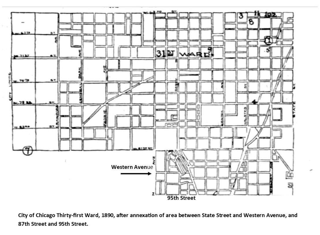
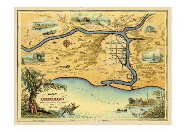
This 1890 map of Chicago includes the new territory of Washington Heights. A bigger version of it can be accessed through Google.
Next post: Assigning Washington Heights to the Ward System
History of the Chicago Wards – Post 2The Beginning
In 1830, Chicago was not yet a city, and Cook County did not exist. For voting in State of Illinois elections, the Chicago area was considered a precinct of Peoria County. Cook County was formed in 1831, and the unincorporated Fort Dearborn settlement at the juncture of the Chicago River and Lake Michigan became the county seat. The area continued to grow, and Chicago incorporated as a city in 1837 and became the county seat.
There are a variety of models for U.S. city governments. Chicago uses a variation of a system brought over from England where wards were administrative units centered around castles. Many American municipalities used the early model of a city council made up of aldermen elected by local citizens to represent geographic units of the city called wards. The council is led by a full-time, paid mayor elected separately, that is, not chosen from or by the aldermen.
Other cities now use other models such as paid city managers or small governing boards with commissioners. The ward system is considered democratic, but can also be cumbersome and result in gridlock. Other systems are considered more efficient, but some are less representative of the will of the people.
The Act of Incorporation for the City of Chicago, 1837, established the city’s form of government, which is the only form the city has ever known. The charter specified as officers an elected mayor heading a “common council” made up of the aldermen from the city wards. Other city officers included a Clerk, a Treasurer, Collectors (for taxes and assessments), and others to be established.
Initially, there were six wards. Two aldermen and one assessor from each ward were elected. Annual elections on the first Tuesday in March for all the offices were mandated.
The “common council” was empowered to handle all aspects of city management, ranging from the control of city finances and property to “preventing the rolling of hoops, playing at ball or flying of kites or any other amusement … having a tendency to annoy persons … or to frighten horses.”
The first six wards were clustered around the site of Fort Dearborn. However, the city didn’t stay small for long. As the city expanded due to population growth and annexation of neighboring communities, the number of wards increased. Also, by 1860, the city had begun to further divide the wards into election precincts. Major acquisition and annexation of land to Chicago occurred during the 1800s, and by 1890, when the Blue Island Ridge territories began to annex, the city was up to 34 wards and 68 aldermen.
Wards were theoretically established based on population size, and determining the boundaries of wards was always a political ordeal.
For example, in 1859, a group proposed that the number of wards be increased from ten to twenty-one because, it was alleged, the wards were too large both population- and geography-wise for efficient voting, resulting in some people having to travel miles to a voting place, and others being denied the opportunity to vote because the lines were so long. The Chicago Tribune called this “brazen lies” and reported the redistribution carved the city into “parallelograms, rhomboids, polygons, diamonds, triangles, and trapezoids, wholly regardless of population, property or propriety.” The paper stated that the “Graveyard on the North Side” (now Lincoln Park) was laid out as a ward in the new system. The proposal went nowhere.
Next post: Washington Heights, including Beverly, is annexed to the City of Chicago and joins the ward system.
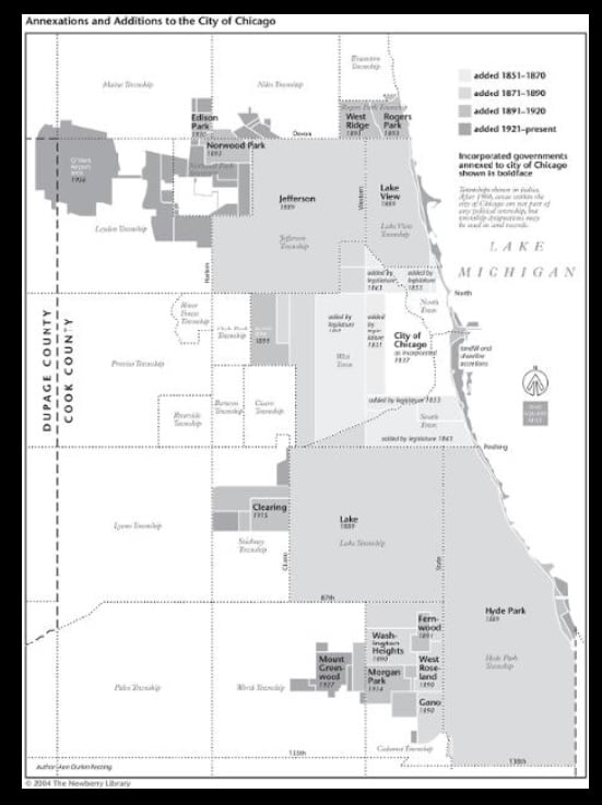
The History of The City Wards in The Ridge Communities – Part IThe Current Picture
As we wrap up one series, the Native Americans on the Ridge, we will also start a new one on the history of the city wards on the Ridge. This series will not be posted on other pages – readers who are interested in this topic are encouraged to follow the Ridge Historical Society page.
“Redistricting” is one of the hot topics in Chicago politics right now, so it’s the perfect time to look at the history of the city ward system in relationship to the neighborhoods that RHS covers. We will start with a review of the situation as it stands today.
The City of Chicago is divided into 50 legislative units called wards. The voters in each ward elect an alderman every four years to represent them on the Chicago City Council, the legislative branch of the city government. The presiding officer of the Chicago City Council is the Mayor, currently Lori E. Lightfoot, and the City Clerk of Chicago, currently Anna M. Valencia, is the secretary. The aldermen elect a President Pro Tempore from within their ranks to serve in the absence of the Mayor. This position is currently held by Brendan Reilly, the alderman of the 42nd ward.
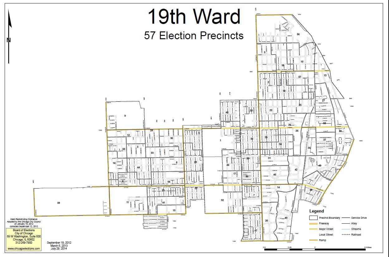
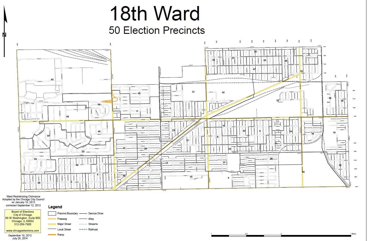
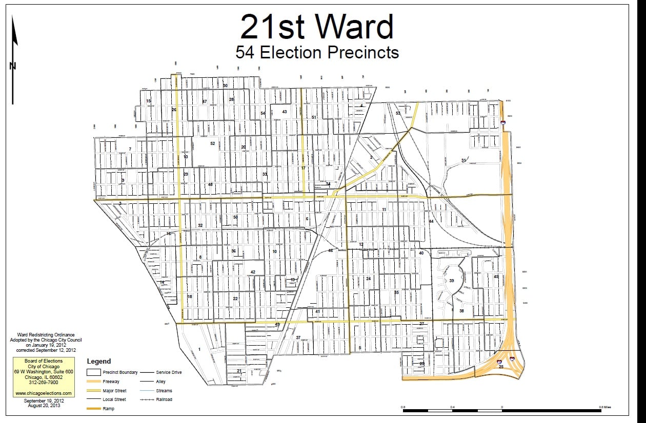
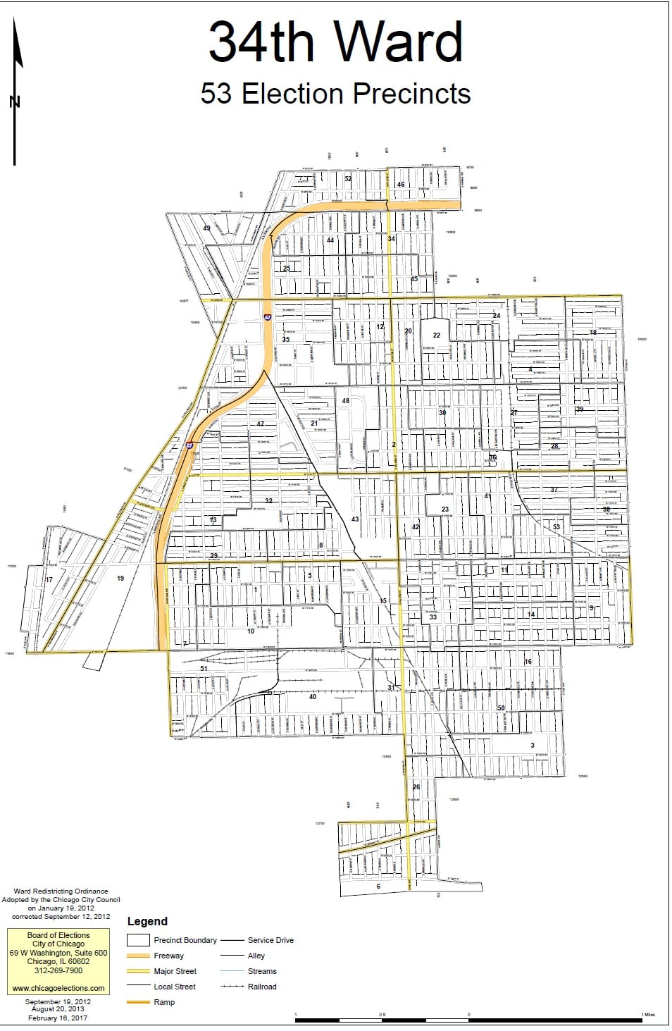
The historical communities represented by the Ridge Historical Society, that is, Washington Heights, Beverly Hills, Morgan Park, and Mount Greenwood, currently fall into four wards – 18 (Derrick G. Curtis, alderman), 19 (Matthew O’Shea, alderman), 21 (Howard Bookins, Jr., alderman), and 34 (Carrie M. Austin, alderman). All of these aldermen are up for re-election in 2023.
Establishing wards and deciding their boundaries have always been intense political exercises in Chicago. The City redraws the ward map every ten years based on population changes reported in the U.S. Census. The goal is to have fifty wards of roughly the same number of residents. Ward boundaries are different from “neighborhood” boundaries, police districts, school districts, etc. All of these geographical – really, geopolitical – divisions are arrived at separately.
If 41 of the 50 aldermen approve a new ward map by an official vote of the City Council, then there is no public referendum on the issue. If no map gets this required support, then voters decide between competing proposals.
Next post: The Origins of The Ward System