
Explore the RHS Facebook Archives, a rich repository of local history written by Carol Flynn. For two decades, Carol brought a deeply dedicated voice to public education at RHS. Her role as Facebook administrator through mid-2025 naturally extended her prolific research into meticulously detailed articles, most notably her multi-part historical series posts. Today, Carol continues her local history writing for The Beverly Review and other outlets.
Natural Ridge


From the Ridge Historical Society: Rain, rain go away. The folks in Beverly want to play … and clean up their flooded basements.
Water comes with the geology of the area. Chicago is built on the bed of an ancient inland sea. Think of Chicago as sitting in a natural basin, sloping up on three sides to the rims of the basin. Lake Michigan is the fourth side. When water is poured into the basin, the basin fills, until it drains off to the lake or it evaporates. Chicago is above sea-level, but not by much, only 575 feet at its lowest point downtown by Lake Michigan. This, of course, is an overly simplistic description of the “water situation” of Chicago and there are many resources available to learn more about this fascinating topic.
Here on the South Side, about 12,000 years ago, an ancient island rose out of prehistoric Lake Chicago, called the Blue Island. The hilly ridge that runs along Longwood Drive was formed by the waves that lapped against the east side of the island. Lake Chicago eventually receded to the east, forming Lake Michigan, leaving behind the table of land known as the Blue Island Ridge or “the Ridge,” which is the highest elevation in the city, about 675 feet.
To the east of the Ridge, before development, the land was a vast system of wetlands and prairies all the way to the lake, punctuated by some forested areas where the land was higher in elevation – some smaller ridges. The animals – deer, wolves – knew by instinct to stick to the higher ground and wore trails into the terrain. The Native Americans used these trails, and then white trappers and traders, and finally settlers. These became the early “roads” – like the Vincennes Trail that ran from Chicago south through the Ridge before turning east into Indiana.
Early histories of the area gave vivid descriptions of what the natural land was like when settlers first arrived. One of the most poetic descriptions came from personal accounts of the Barnard family, which settled on the Ridge in the 1840s.
Here are some excerpts from that writing:
Looking south from what is now 101st and Longwood, “the view between the hill and the ridge where the Dummy Track now runs [today’s Metra line], was a slough in which the waters seldom dried up even in midsummer, and the greater part of the season was difficult to cross. Conclusive of this fact it is stated, a sandhill crane, as late as in the [1860s], built her nest for several years between Uncle Erastus’ house [104th and Wood] and the site of the Tracy depot [103rd and Wood], unmolested. No one would wade out after the eggs. Also, when he fenced his farm, the corner of Wood and Belmont Avenue [107th Street] was left without fencing, the water there being so deep that the cattle would not cross…. This slough was covered with a growth of coarse grass edged by high weeds. The weeds were thickest for two or three rods [a rod is 16.5 U.S. survey feet] just under the bluff, especially where the ravines poured their waters into the lowlands. Here, in autumn, wild artichokes, wild sunflowers, and iron weed waved their yellow flowers high above the heads of the tallest men. The ravine opposite Mr. Hauke’s was known as Horse Thief Hollow. Here horse thieves utilized their friendly shade as a hiding place.”
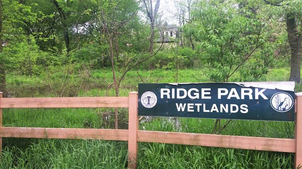
What this is telling us is that about 150 years ago, all that land from Longwood Drive east and south from about 101st Street was a vast slough, or wetland, that never dried up. The prairie and wetlands extended to the north and east of the Ridge also, but were less dramatic. The Ridge Park Wetlands between 95th and 96th Streets just west of the Metra tracks give a tiny inkling of what the area looked like back then. Right now, they are swollen with water from the recent heavy rains.
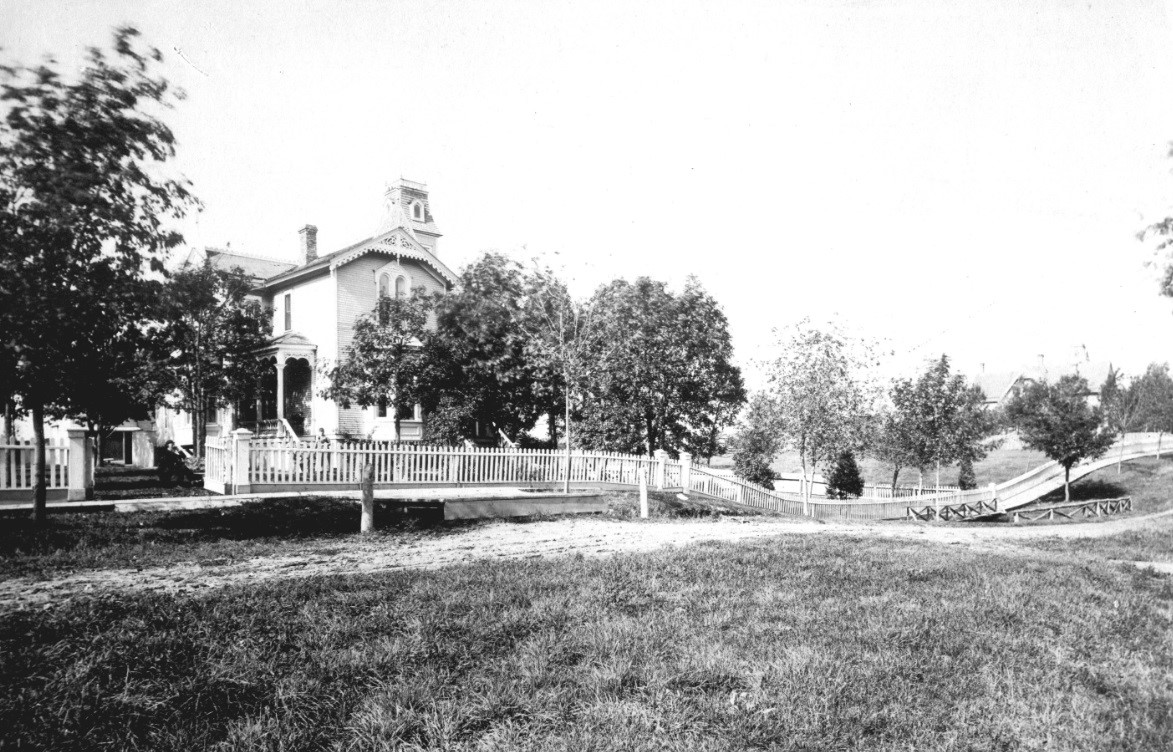
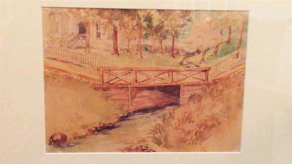
Streams that cut through the Ridge poured their waters into this land to the east. An early photo shows the charming George Chambers House, built in 1874, at 10330 S. Seeley Ave. In the picture, there is a bridge over a substantial stream that flowed down into the wetlands.
This house still stands, and there is a steep dip in the street where this stream was. You can see this ravine between the houses on Longwood Drive. This stream is likely still there, underground, heading southeast.
Louise Barwick, an artist who lived in that house around 1900, painted a watercolor of that stream and bridge, and the painting is in the RHS collection.
The bottom line of this story: Houses built to the east of the Ridge are built on natural wetlands. With heavy rainfall, this becomes all too evident.
As far as the reference to Horse Thief Hollow, the exact location of Mr. Hauke’s house has not been identified, but it was likely around 108th Place. There was a very deep ravine here, and early histories that identified a certain ravine as the place where evidence of horse thieves hiding out was found are likely referring to this location. The entire area was known as Horse Thief Hollow in the 1830s -1840s, but that is a topic for another day.
Part II will share more of the Barnards’ descriptions of the natural environment of the Ridge areas. Stay tuned.


From the Ridge Historical Society, Part I: Rain, rain go away. The folks in Beverly want to play … and clean up their flooded basements.
Water comes with the geology of the area. Chicago is built on the bed of an ancient inland sea. Think of Chicago as sitting in a natural basin, sloping up on three sides to the rims of the basin. Lake Michigan is the fourth side. When water is poured into the basin, the basin fills, until it drains off to the lake or it evaporates. Chicago is above sea-level, but not by much, only 575 feet at its lowest point downtown by Lake Michigan. This, of course, is an overly simplistic description of the “water situation” of Chicago and there are many resources available to learn more about this fascinating topic.
Here on the South Side, about 12,000 years ago, an ancient island rose out of prehistoric Lake Chicago, called the Blue Island. The hilly ridge that runs along Longwood Drive was formed by the waves that lapped against the east side of the island. Lake Chicago eventually receded to the east, forming Lake Michigan, leaving behind the table of land known as the Blue Island Ridge or “the Ridge,” which is the highest elevation in the city, about 675 feet.
To the east of the Ridge, before development, the land was a vast system of wetlands and prairies all the way to the lake, punctuated by some forested areas where the land was higher in elevation – some smaller ridges. The animals – deer, wolves – knew by instinct to stick to the higher ground and wore trails into the terrain. The Native Americans used these trails, and then white trappers and traders, and finally settlers. These became the early “roads” – like the Vincennes Trail that ran from Chicago south through the Ridge before turning east into Indiana.
Early histories of the area gave vivid descriptions of what the natural land was like when settlers first arrived. One of the most poetic descriptions came from personal accounts of the Barnard family, which settled on the Ridge in the 1840s.
Here are some excerpts from that writing:
Looking south from what is now 101st and Longwood, “the view between the hill and the ridge where the Dummy Track now runs [today’s Metra line], was a slough in which the waters seldom dried up even in midsummer, and the greater part of the season was difficult to cross. Conclusive of this fact it is stated, a sandhill crane, as late as in the [1860s], built her nest for several years between Uncle Erastus’ house [104th and Wood] and the site of the Tracy depot [103rd and Wood], unmolested. No one would wade out after the eggs. Also, when he fenced his farm, the corner of Wood and Belmont Avenue [107th Street] was left without fencing, the water there being so deep that the cattle would not cross…. This slough was covered with a growth of coarse grass edged by high weeds. The weeds were thickest for two or three rods [a rod is 16.5 U.S. survey feet] just under the bluff, especially where the ravines poured their waters into the lowlands. Here, in autumn, wild artichokes, wild sunflowers, and iron weed waved their yellow flowers high above the heads of the tallest men. The ravine opposite Mr. Hauke’s was known as Horse Thief Hollow. Here horse thieves utilized their friendly shade as a hiding place.”
What this is telling us is that about 150 years ago, all that land from Longwood Drive east and south from about 101st Street was a vast slough, or wetland, that never dried up. The prairie and wetlands extended to the north and east of the Ridge also, but were less dramatic. The Ridge Park Wetlands between 95th and 96th Streets just west of the Metra tracks give a tiny inkling of what the area looked like back then. Right now, they are swollen with water from the recent heavy rains.
Streams that cut through the Ridge poured their waters into this land to the east. An early photo shows the charming George Chambers House, built in 1874, at 10330 S. Seeley Ave. In the picture, there is a bridge over a substantial stream that flowed down into the wetlands.
This house still stands, and there is a steep dip in the street where this stream was. You can see this ravine between the houses on Longwood Drive. This stream is likely still there, underground, heading southeast.
Louise Barwick, an artist who lived in that house around 1900, painted a watercolor of that stream and bridge, and the painting is in the RHS collection.
The bottom line of this story: Houses built to the east of the Ridge are built on natural wetlands. With heavy rainfall, this becomes all too evident.
As far as the reference to Horse Thief Hollow, the exact location of Mr. Hauke’s house has not been identified, but it was likely around 108th Place. There was a very deep ravine here, and early histories that identified a certain ravine as the place where evidence of horse thieves hiding out was found are likely referring to this location. The entire area was known as Horse Thief Hollow in the 1830s -1840s, but that is a topic for another day.
Part II will share more of the Barnards’ descriptions of the natural environment of the Ridge areas. Stay tuned.
From the Ridge Historical Society
Part V on the “natural Ridge”
-Carol Flynn, RHS Communucations
As a follow up to the posts on the early history of the Ridge as told to us by W. W. Barnard, we received some interesting questions and comments. Here are a few, plus responses.
Q: What is the oldest home in area? Chambers home seems likely.
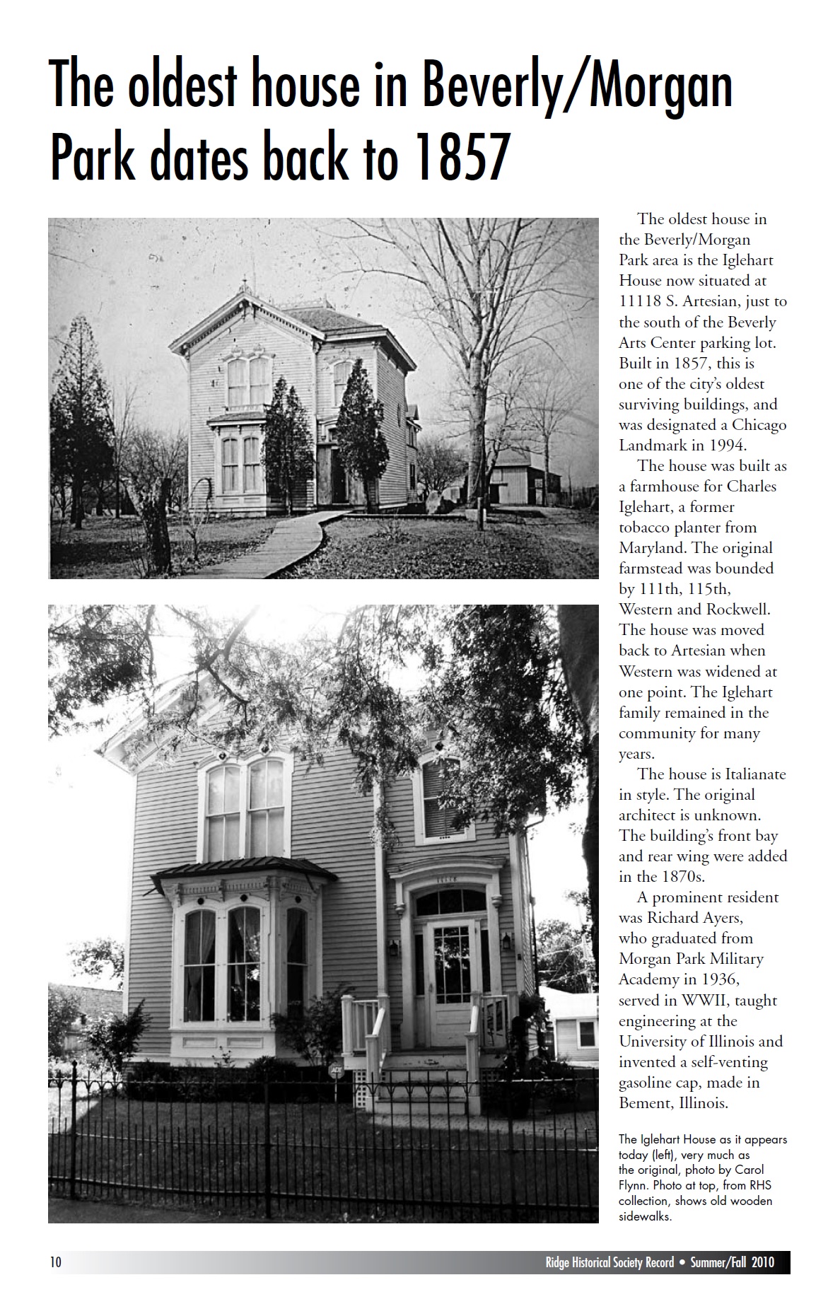
A: The Chambers House at 10330 S. Seeley Ave. was built in 1873, making it one of the oldest houses still standing. But the oldest house in the area on record is the Charles D. Iglehart House at 11118 S. Artesian Ave. Built in 1857, it is one of the oldest houses in Chicago. It originally was on Western Ave., surrounded by orchards, but was moved back when Western was graded and widened and paved. A photo of a newsletter article from RHS is attached.
Q: We live at 96th Winchester and have wondered if Lake Chicago basically lapped up to Longwood drive. Was that the shore?
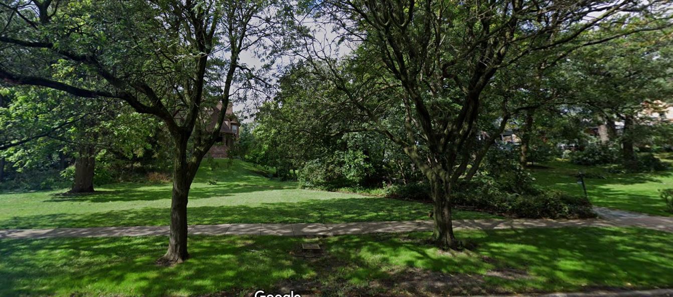
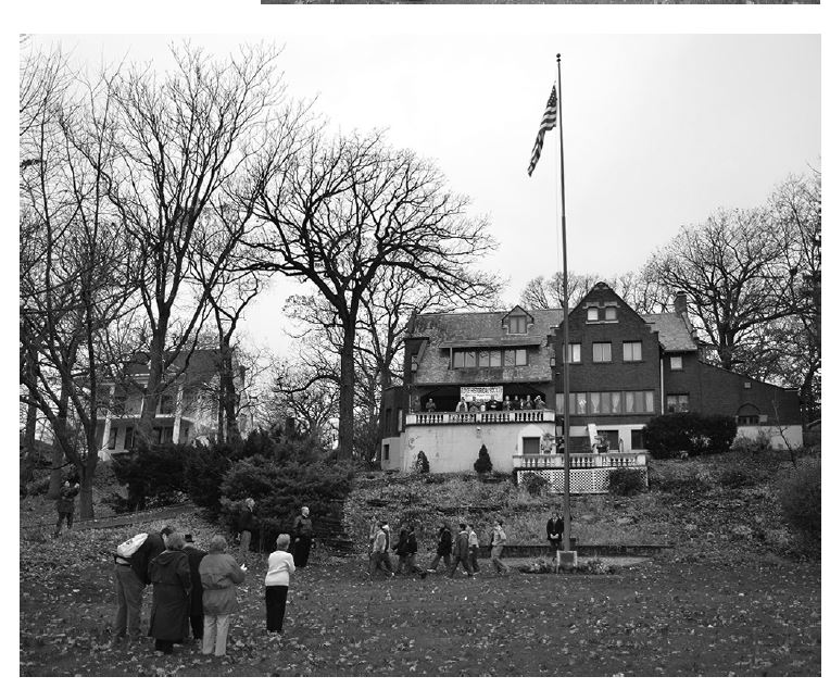
A: Yes, Longwood Drive runs along the base of the Ridge, the east side of the prehistoric Blue Island. The “ridge” was cut by waves lapping against that shore. The Longwood Drive lawn of the Ridge Historical Society (see picture), the Graver-Driscoll House at 10616 S. Longwood Drive (entrance at 10621 S. Seeley Ave.), gives a good example of the ridge. The lawn starts out with a gradual slope, then increases greatly in steepness until the top of the ridge. The architect who designed this house, John Todd Hetherington, built the terraces down the ridge, making great use of the natural terrain, nestling the house right into the ridge. Many of the early houses had entrances on both Longwood and the street to the west, Seeley, Lothair, etc. The driveways became too treacherous especially in winter for horse and buggy to use.
Q: [Are the natural wetlands] the reason I have so much clay in my soil?
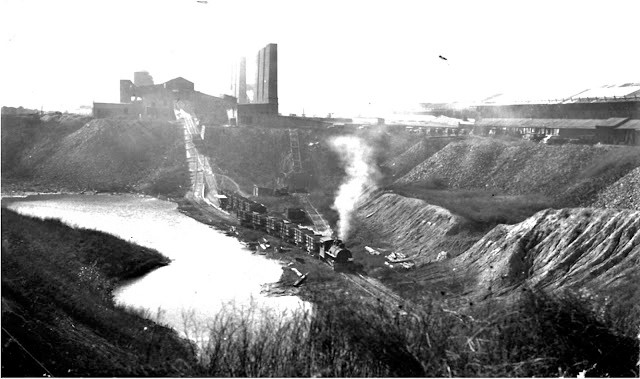
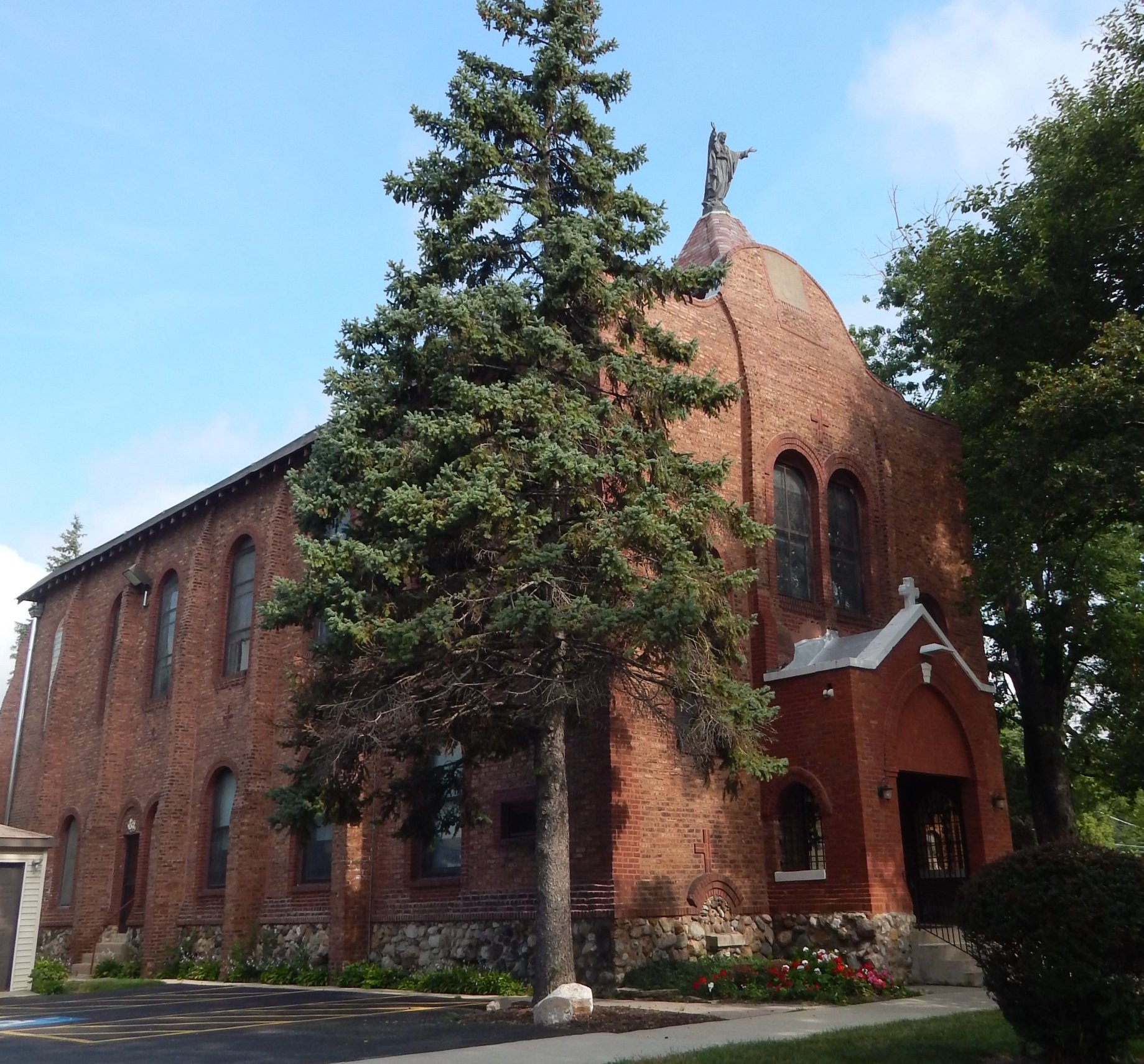
A: Yes, according to the Encyclopedia of Chicago, "The glacial lakebed soils have a clayey subsoil with a thick, rich, dark topsoil, the product of wet prairies." There were vast clay deposits just to the south of us, and brick making was a very big industry in early Blue Island. The Purington Brick yards were at 119th and Vincennes. The Meadows Golf Club, on 123rd Street, owned by the City of Blue Island, is built on top of old clay pits. Sacred Heart Church at 116th and Church Street in Morgan Park is covered with Purington bricks. The early French settlers who worked at the brickyards were allowed to take brick “seconds” to use for the church. Eventually they had enough to clad the frame building with bricks. Today, the original frame church is still under the bricks. See pictures.
Comment: I had a very old neighbor who said she saw Indians in the park, many wild goats and even cows.
A: This is completely believable. Native Americans had a very strong presence in this area. There were many Indian villages along the Calumet River and Stony Creek, and throughout the entire southwestern suburbs. The Treaty of Chicago in 1833 led to the Potowatomi Tribe leaving the area to move west of the Mississippi. Of course, it took a number of years for all of them to relocate, and not all of them left. Erastus Barnard, the uncle of W.W. Barnard, whose remembrances we are sharing, watched a wagon train of Indians leave in 1847. For decades afterwards, the settlers still saw and interacted with Indians in the area. One settler reported in his old age that as a youth he rode his pony with Indians across the prairie.
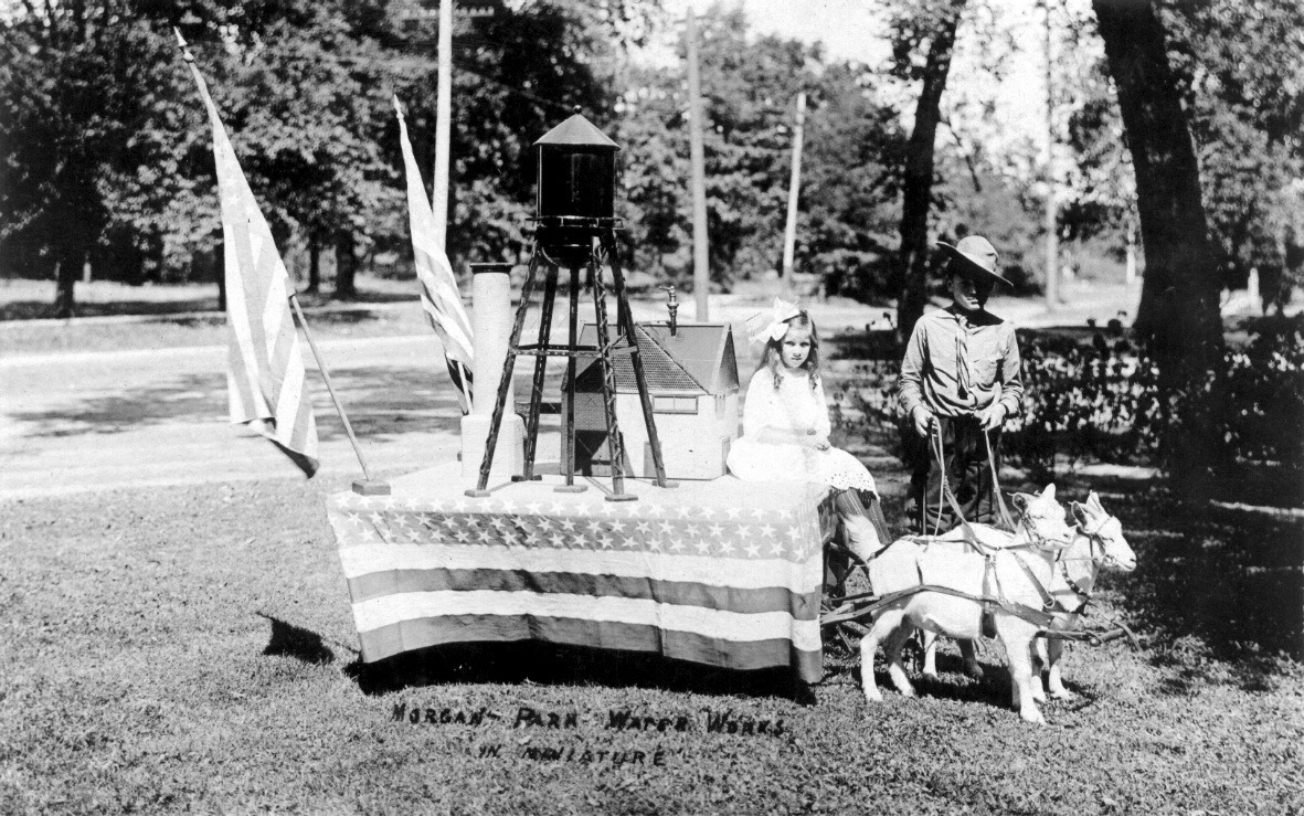
As far as sighting goats and cows, in the early years, cattle and other livestock grazed the prairie. The Morgans let their neighbors use their land on the top of the Ridge for grazing. Also, W. W. Barnard reported that cattle, hogs, sheep and even turkeys drifted across the prairie by the thousands, being driven to the stockyards in Chicago. There certainly were escapees. Even later, when the land was fenced and farms were well established, there were stories of escaped family cows having to be rounded up and brought home. Goats were popular for milk, meat, and as pets to pull carts. See picture.
Next up, for Memorial Day: Civil War soldiers and the Ridge.