
Explore the RHS Facebook Archives, a rich repository of local history written by Carol Flynn. For two decades, Carol brought a deeply dedicated voice to public education at RHS. Her role as Facebook administrator through mid-2025 naturally extended her prolific research into meticulously detailed articles, most notably her multi-part historical series posts. Today, Carol continues her local history writing for The Beverly Review and other outlets.
2021
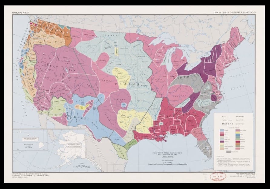
Native Americans and the Blue Island Ridge – Part 2Native Americans and the United States
The United States of America is built upon land that was a vast network of homelands to many different groups of Indigenous Peoples before the European explorers “discovered” this “New World” – new to them, that is. Although the origin and timing of the arrival of the first humans on this landmass continue to be studied and debated, the Native American presence dates back at least 15,000 years.
Native Americans are referred to by several different terms – American Indians, First Americans, Indigenous Americans. In a 1995 U.S. Census Bureau survey, a plurality of this group said they prefer American Indian. The term “Indian” is often used in their organizations, such as the American Indian Center of Chicago, located on the north side of the city. These RHS posts will use the terms interchangeably.
There is no single Native American culture, language, or lifestyle – there were many different groups here when the Europeans arrived. Today, the U.S. government recognizes 574 tribes living in the forty-eight contiguous states and Alaska. “Native Hawaiian and Other Pacific Islander” is a separate group. About half of the people who make up the 574 tribes are associated with reservations.
The 574 number is not historically determined or permanently fixed. Groups may petition to be acknowledged as an official tribe. Right now, eleven groups are going through the petitioning process. Closest to Chicago is the Grand River Bands of Ottawa Indians in Michigan.
Researching American Indian history presents certain challenges. For most Native American groups, the traditional means of transmitting and understanding history has been through the oral tradition. Stories and history were and are verbally passed down from generation to generation. The emphasis is on identity, relationships, and interactions, including with the spirit world. History was not recorded as a chronological sequence of dates and events.
Much of the history of Native Americans that is available has been amassed primarily by researchers and academicians of European descent, and filtered through their viewpoints. They present and interpret what they consider important about Native American history, not what Native Americans consider important about their own history. The Native American viewpoint is every bit as important as the viewpoint of the people who came later.
In developing these posts, RHS is looking for resources that cover history from the Native Americans’ perspective. This is a learning experience for all of us.
The arrival of the European explorers, missionaries, traders, and settlers obviously had a profound effect upon the Native Americans, forever altering their ways of life, cultures, and the relationships between tribes.
Most Native Americans died from diseases introduced by the Europeans, to which they had no natural immunities. Smallpox, measles, influenza, cholera, etc., resulted in the deaths of 90% of Native Americans.
Native Americans inevitably became involved in conflicts and wars, primarily over land. A major reason conflicts with the European settlers arose was because the settlers were clearing land for farms, destroying the lands the Native Americans depended upon for hunting and gathering food. Settlers also destroyed Indian burial sites and other locations sacred to the local Native Americans.
The European settlers often used religion as their justification for the subjugation of native peoples – it was ordained by God that they should dominate the natives, convert them to Christianity, take their land, and force them to assimilate – or perish. More on this will be covered in future posts.
Native Americans became involved in wars between European countries fought on Native American lands. Some major conflicts included the French and Indian War, 1763; the American Revolution, 1776; the War of 1812; and the Black Hawk War, 1832. After this last war, Native Americans left the Chicago area.
With each encounter, no matter what side they were on, the Native Americans were negatively impacted. They were left out of peace negotiations and driven from more and more of their ancestral lands. The winning side often retaliated against the Native Americans who sided with the enemy.
The Second Continental Congress of 1775, before the American Revolution and the establishment of the U.S., created a Committee on Indian Affairs, headed by Benjamin Franklin. The role was to establish treaties with tribes so the tribes would be neutral in the independence movement.
The U.S. Constitution includes as Article I, Section 8, a description of Congress's role with Indian affairs: "To regulate commerce with foreign nations, and among the several States, and with the Indian tribes."
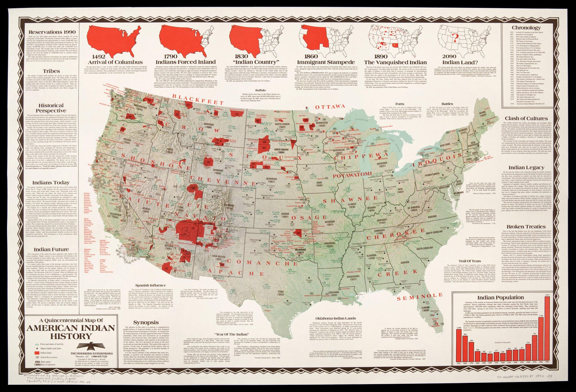
In 1789, Indian Affairs was moved to the newly formed U.S. War Department. The Bureau of Indian Affairs (BIA), a Federal agency, was established in 1824, under President James Monroe. The BIA became part of the Department of the Interior (DOI) when DOI was formed in 1849. During these earliest years, efforts were concentrated on overseeing the fur trade with the Indians, and removing them from their ancestral lands by treaty or force in order to aid settlement, and relocating them to land usually further west.
Next Post: Native Americans and the Chicago Area
Native Americans and the Blue Island Ridge – Part 3Native Americans and the Chicago area
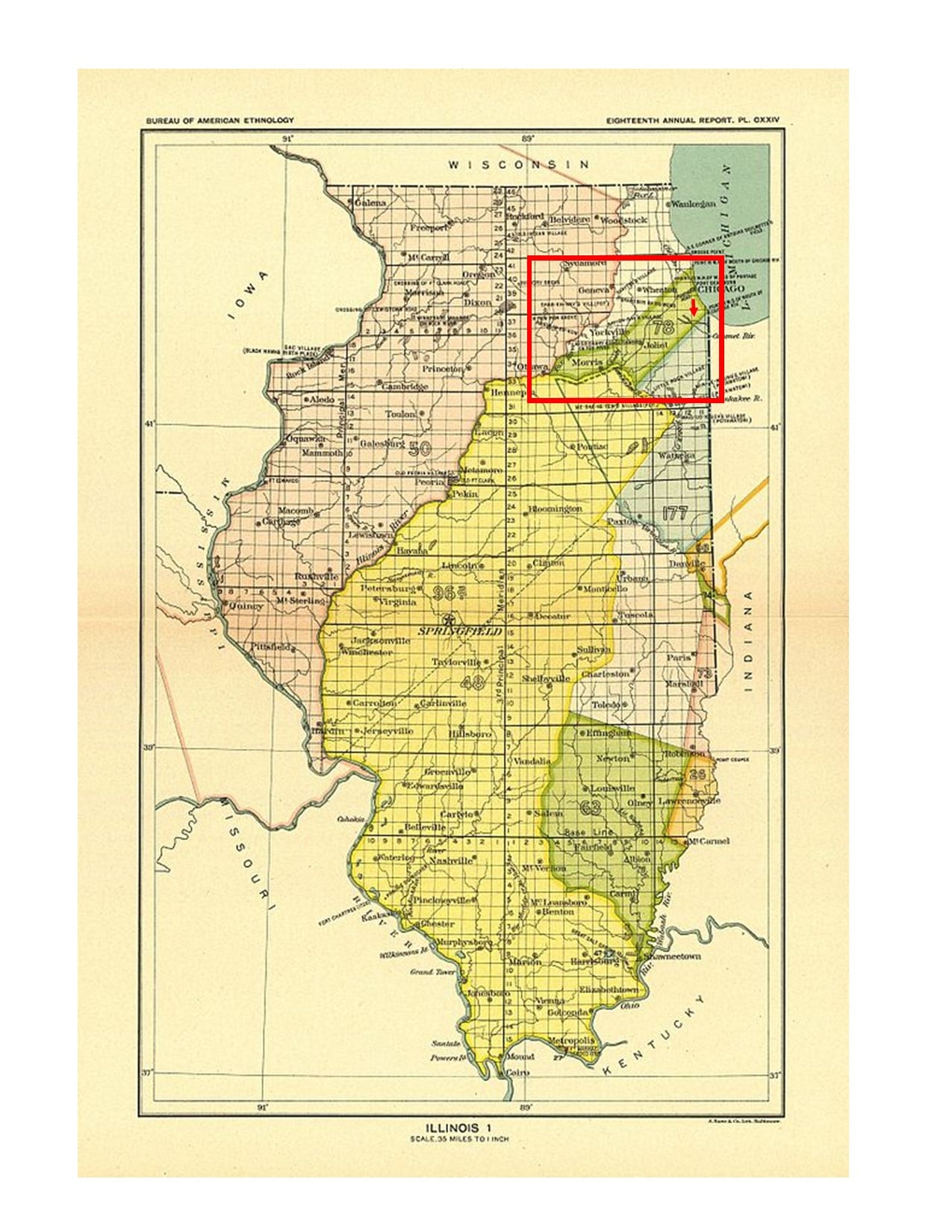
The greater Chicago area includes ancestral lands of 25 to 30 distinct Native American groups. By the time the Native Americans gave up the land via treaty with the U.S. Government and left the area in 1833-35, the predominant group living here were the Potawatomi people.
The Field Museum of Natural History has a vast collection on the Native peoples of North America and, since 2018, has been in the process of transforming the Native North American Hall.
The Field Museum issued a Land Acknowledgement Statement which reads:
We acknowledge that the Field Museum resides within the traditional homelands of many Indigenous nations:
• Hoocąk (Winnebago/Ho’Chunk), Jiwere (Otoe), Nutachi (Missouria), and Baxoje (Iowas)
• Kiash Matchitiwuk (Menominee)
• Meshkwahkîha (Meskwaki)
• Asâkîwaki (Sauk)
• Myaamiaki (Miami), Waayaahtanwaki (Wea), and Peeyankihšiaki (Piankashaw)
• Kiikaapoi (Kickapoo)
• Inoka (Illini Confederacy)
• Anishinaabeg (Ojibwe), Odawak (Odawa), and Bodéwadmik (Potawatomi)
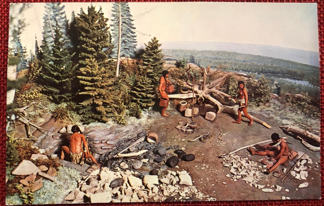
Archeologists divide Native American history into eras or “traditions” and these eras are further broken down into more exact time periods and cultures. Very little is known about the earliest Indigenous Peoples who lived on the land dating back 3,000 years ago and before. Information becomes more available with the Woodland Tradition from 3,000 to 1,100 years ago, and the Mississippian Tradition which began about 1,100 years ago. More on these eras and Native American life during these times will be in future posts.
The term “confederacy” appears for some Native American groups. A confederacy is a union of sovereign groups that come together for common action. The Illini or Illinois Confederacy listed above was made up of a dozen tribes ranging east and south from Lake Michigan. Most of the Illini groups were destroyed by diseases introduced by the Europeans, or through war with other tribes. Their descendants are found today as part of the Peoria Tribe of Miami, Oklahoma.
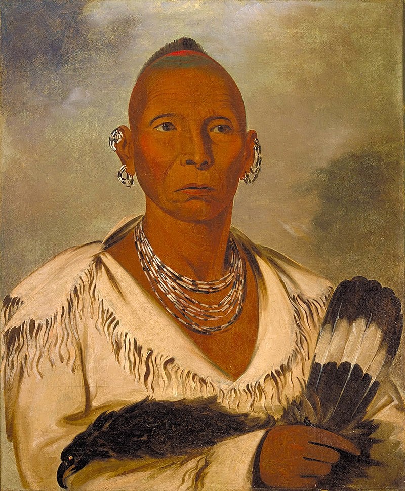
The last group listed above is the Ojibwe, Odawa, and Potawatomi. These groups make up the Three Fires Confederacy or the Council of Three Fires. This is a long-standing alliance dating back for over a thousand years, that has a complex structure and operating system. The three tribes in this alliance are listed in a specific order – the Ojibwa or Chippewa are the “Older Brother,” the Keepers of Medicine. The Odawa or Ottawa are the “Middle Brother,” the Keepers of Trade. The Potawatomi are the “Younger Brother,” the Keepers of the Fire.
Only the Potawatomi actually lived in the Chicago area in any number, but as an alliance they all signed the treaty that resulted in Native Americans leaving the area in the 1830s. In 1830, there were forty Potawatomi communities in northern Illinois and thirty-six in northeast Indiana, with a total population over 6,000.
Many Land Acknowledgement Statements (LAS) in the Chicago area make reference to the Council of Three Fires. For example, the LAS for the Forest Preserves of Cook County reads: “The Forest Preserves of Cook County acknowledges that we are on the ancestral homelands of the Council of Three Fires—the Ojibwa, Ottawa and Potawatomi tribes—and a place of trade with many other tribes, including the Ho-Chunk, Miami, Menominee, Sauk and Meskwaki.”
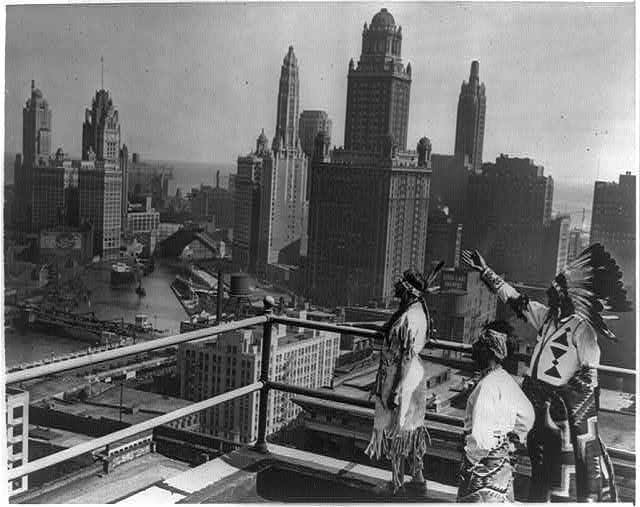
Photo: “Princess O-Me-Me, a Chippewa; Sun Road, A Pueblo; and Chief Whirling Thunder, a Winnebago, looking over Chicago's skyline from the roof of the Hotel Sherman.” October 3, 1929. From the Library of Congress.
The Chippewa and Winnebago tribes had ancestral land in the Chicago area. The Pueblo Indians were mostly in the southwest area, Arizona and New Mexico.
Next: More on Native Americans and the Chicago area – Fort Dearborn, treaties
Ridge Historical Society
June 2021
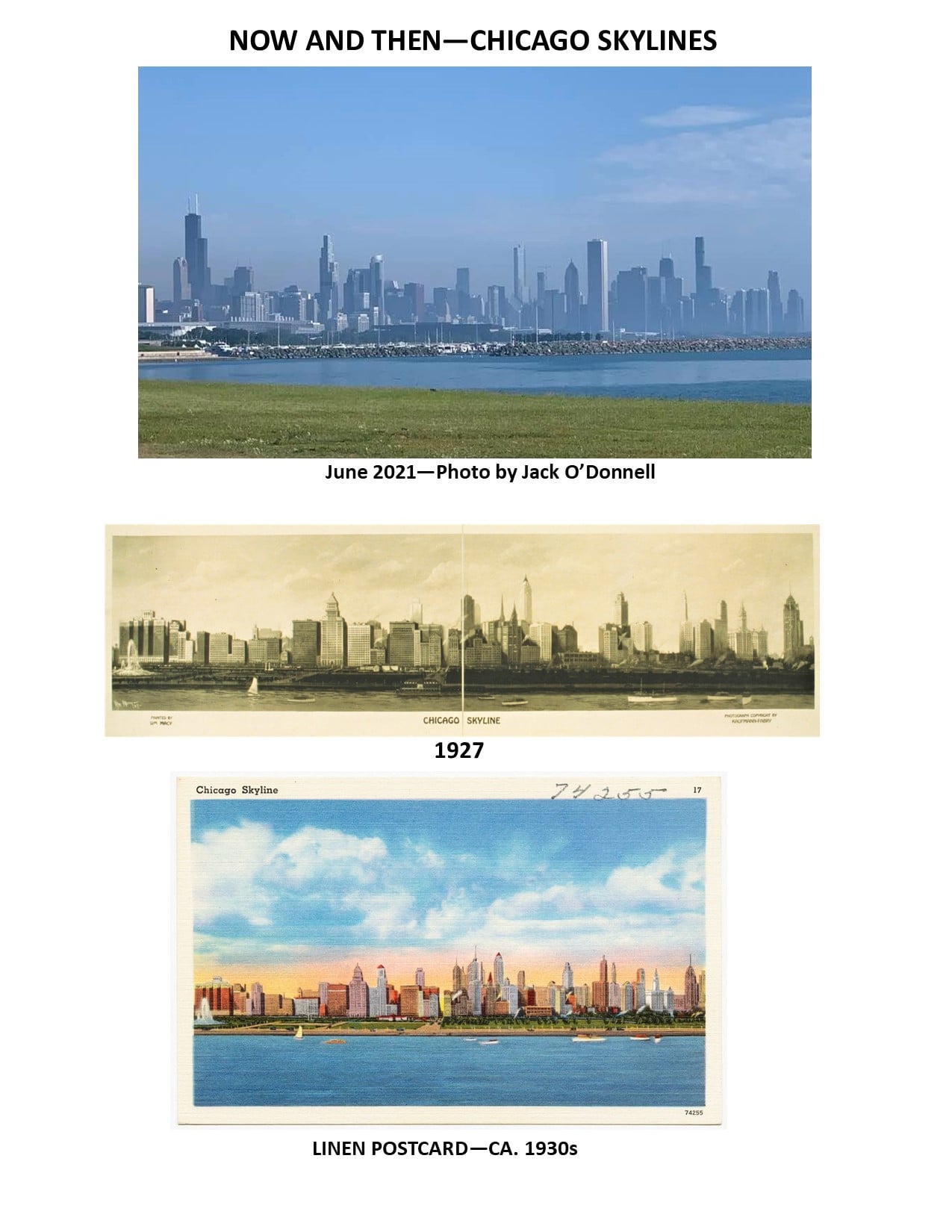
Thank you to Jack ODonnell for the wonderful picture of today's Chicago timeline.
Native Americans and the Blue Island Ridge – Part 4Fort Dearborn; Treaties
The first recordings of European explorers, missionaries and traders coming through the Chicago territory date to the 1670s. At the time, the Miami Confederacy, which included the Mascouten, Illini, and Kickapoo tribes as well as the Miami, were predominant in the area. The name “Chicago” was adopted for the region at this time from the French take of the Miami-Illinois word for the wild garlic that grew in the area.
Chicago’s location as a canoe portage connecting the Great Lakes with the Mississippi River made it strategically important. Conflicts between Native American tribes led to the Iroquois and Meskwaki (Fox) driving out the Miami from the Chicago area by the end of the 1720s. The Pottawatomi assumed control of the area.
Conflicts over control of the lands around the Great Lakes, called the Northwest Territory and including much of what today is Ohio, Indiana, Illinois, Michigan, Wisconsin, and the northeastern part of Minnesota, went on for over a century. The French, the English, the newly established United States, and Native American tribes organized as the Western Confederacy all vied for control. The Western Confederacy included the Three Fires Confederacy of the Ojibwa, Odawa, and Potawatomi, and other tribes.
In 1794, the Battle of Fallen Timbers in what is now Ohio was the final battle in the Northwest Indian War, which was a struggle between tribes affiliated with the Western Confederacy and their British allies, aligned against the new United States. The U.S. won a tenuous hold of the land in the Northwest Territory, and two treaties were signed.
The Treaty of Greenville defined boundaries for Native American lands and for United States land. The important part of this treaty as it pertains to the Ridge is that the treaty allocated strategic tracts of land within the Indian Country for establishing U.S. Army posts, the most important of which was “six square miles” that was the future site of Fort Dearborn. The second treaty, the Jay Treaty, negotiated the withdrawal of British Army units from the territory.
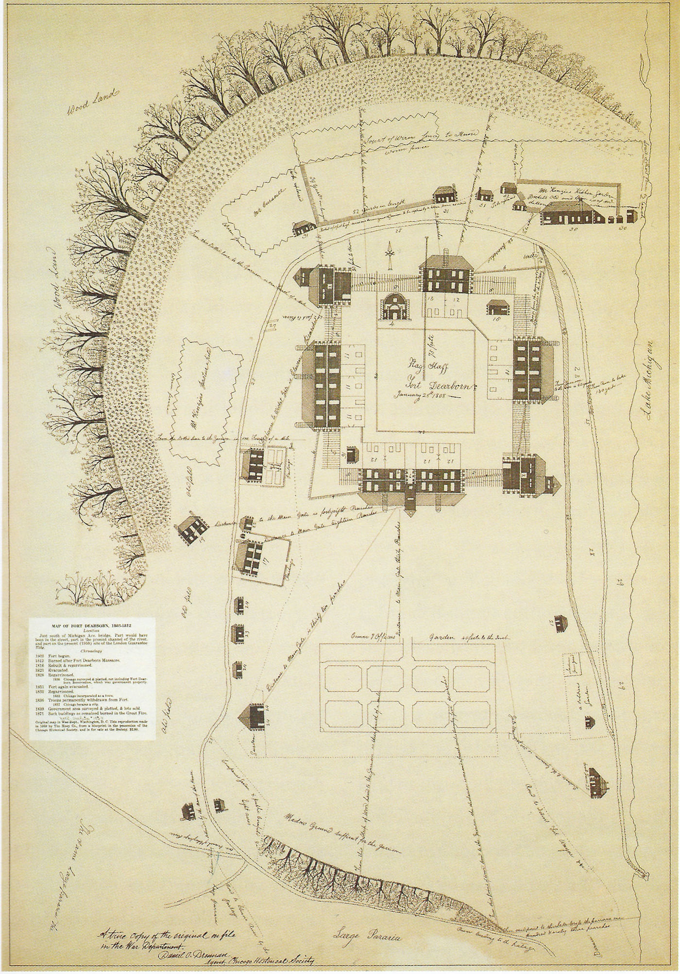
Fort Dearborn was constructed by U.S. troops under the command of Captain John Whistler in 1803. The fort was named for Henry Dearborn, the Secretary of War. It was located where the Chicago River joins Lake Michigan at what today is Wacker and Michigan Avenues.
Note that the Ridge community has a grammar school named for John Whistler at 115th and May Streets that was dedicated in 1959. A profile of John Whistler will be posted as part of the RHS series about the people for whom schools on the Ridge are named.
Fur trader John Kinzie came to Chicago in 1804, purchasing the property of the original settler in Chicago, Jean Baptiste Point du Sable. Kinzie became the civilian leader of the small settlement that grew around the fort. Whistler and Kinzie got into a dispute over Kinzie selling alcohol to the Native Americans.
Tensions in the Illinois Territory remained high. The U.S. settlers continued to expand westward, claiming land for farmland, mineral deposits, and the fur trade. Native Americans led by Tenskwatawa, a Shawnee prophet, and his brother Tecumseh wanted to block U.S. expansion into their lands. The U.S. was not adhering to the treaties it had signed with the Native Americans. Britain saw this as an opportunity to reclaim the land and provided guns to the Native Americans. Attacks on U.S. settlers by the Native Americans increased tensions between Britain and the U.S.
Next post: The War of 1812 and the Battle of Fort Dearborn.
Native Americans and the Blue Island Ridge – Part 5The Battle of Fort Dearborn
Fort Dearborn was built at the junction of the Chicago River and Lake Michigan in 1803 on land that Native Americans turned over to the new U.S. government by treaty after defeat in the Northwest Territory Indian Wars. The British, who had been allies of the Native Americans, also gave up their military presence in the Northwest Territory at that time.
However, even though the newly formed United States had won that war and claimed the Northwest Territory for its expanding borders, tensions between all the parties remained high.
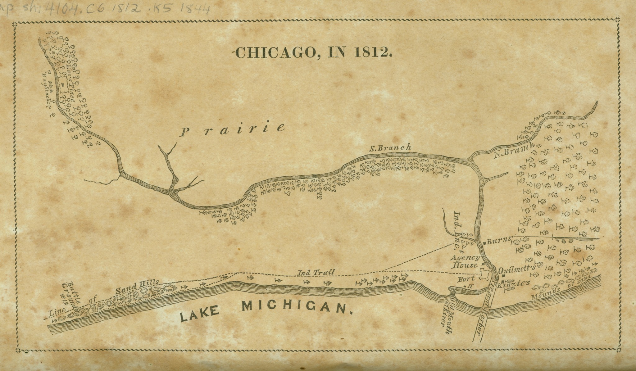
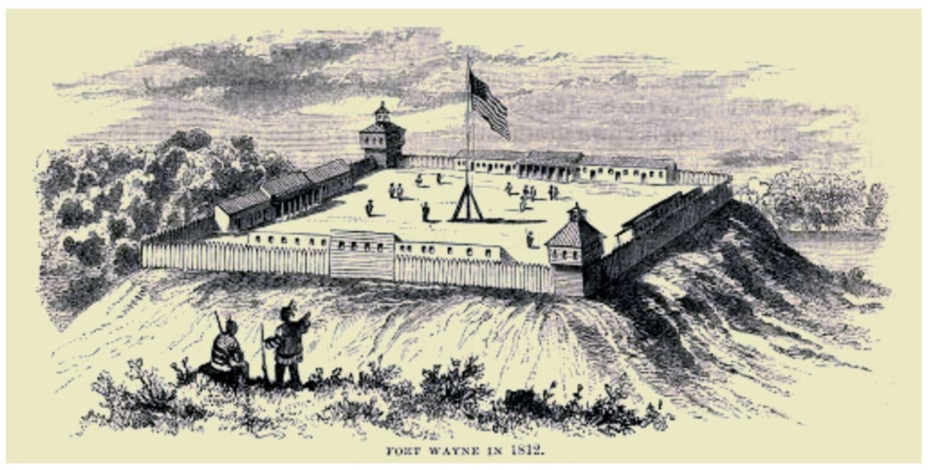
The “Chicago” area had over 40 Potawatomi villages in the early 1800s. Many Indian trails intersected just south of the Blue Island Ridge. It was a hub for the fur trade. As far as white settlement was concerned, it was remote wilderness at the time. Other U.S. forts were hundreds of miles away, such as Fort Wayne, located 200 miles to the east, where Fort Wayne, Indiana, is today.
U.S. settlers continued to expand into land designated by treaties for Native Americans, destroying the Indians’ ancestral lands and sacred sites in order to establish farmland and settlements. The U.S. government did not abide by the treaties it signed with the Native Americans. Great Britain saw the growing friction between the new U.S. government/settlers and the Indigenous People as an opportunity to further buffer their Canadian colonies from possible U.S. infringement, and possibly to try to win back some of the Great Lakes territories.
In 1811, British emissaries began enlisting Native Americans in the Fort Dearborn area against the U.S. settlers. The British told the Native Americans they would help protect their land from further encroachment. A U.S. citizen and a French-Canadian man were killed by a band of Winnebago Indians in what is now the Bridgeport section of Chicago. This inflamed tensions between the settlers and the Indians in the area, causing some settlers to move into Fort Dearborn and an armed militia from the fort to be formed.
In 1812, the U.S. declared war on the British empire and the War of 1812 began. In addition to conflicts over the land in North America, there were also continuing economic and trade disputes involving the U.S., Britain, and France. The British Royal Navy was seizing U.S. ships on the open sea and forcing people who claimed to be citizens of the new U.S. into service for Britain (called “impressment”).
The British, moving south from their Canadian colonies, captured Fort Mackinac in Michigan. Worried that Fort Dearborn in “Chicago” could not be sustained, evacuation of the fort was ordered. Captain Nathan Heald, in command of Fort Dearborn, was ordered to destroy arms and ammunition and give remaining goods to friendly Indians to attain an escort to Fort Wayne. A group of 30 Miami tribesmen came from Fort Wayne to Fort Dearborn with a U.S. agent to provide an escort.
Heald met with local Potawatomi leaders to let them know he was evacuating the fort. The Indians understood Heald to say he would distribute the firearms, ammunition, provisions, and whiskey among them, and that, if they would send a band of Potawatomi to escort them safely to Fort Wayne, he would pay them a large sum of money. However, Heald destroyed the firearms, ammunition, and liquor.
Potawatomi Chief Black Partridge warned Heald that the young men of the tribe planned to attack the evacuating party and he could not restrain them. Despite the warning, Heald went ahead with the evacuation as ordered.
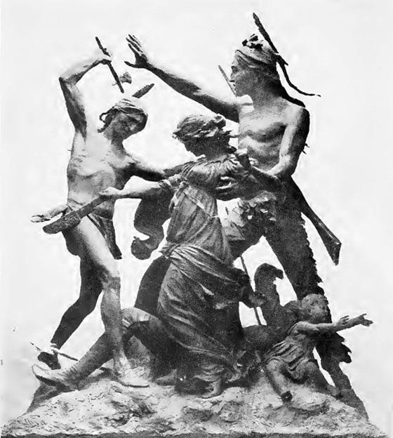
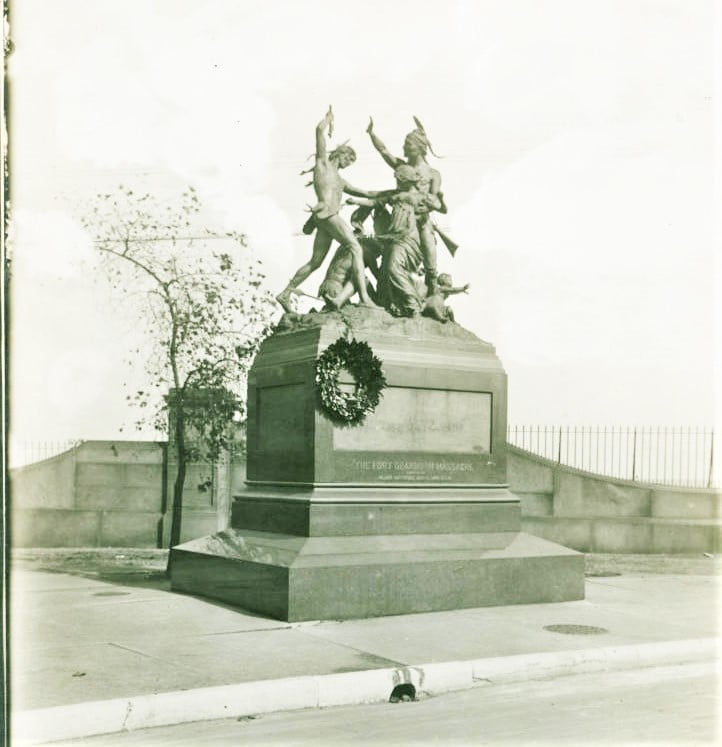
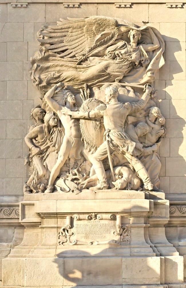
On August 15, 1812, the garrison left Fort Dearborn for Fort Wayne. There were 66 military men, nine women, 18 children, and the Miami escorts. They were attacked by 400 to 500 Potawatomi. Thirty-eight of the military, two women and twelve children were killed, and the rest were taken as prisoners. Fifteen Potawatomi were killed. Fort Dearborn was burned down.
Potawatomi Chief Black Partridge (sometimes translated as Black Pheasant) and his brother Waubonsie were not successful in stopping the attacks, but they and other Native American leaders in the area did what they could to aid the evacuees from Fort Dearborn. Black Partridge advocated for peaceful relations with the U.S. He was credited with saving the life of Mrs. Margaret Helm during the attack, and helping to free her husband, Lt. Lenai Helm. [However, when he returned to his village, he discovered that it had been burned by U.S. troops and among the massacre victims were his daughter and grandchild. He then joined in opposition to the U.S. A later battle included a young warrior named Black Hawk, a member of the Sauk, who will be discussed in a later post.]
The prisoners were sold to the British, who ransomed them back to the U.S. or set them free. Heald and his wife, both injured, escaped to Fort Detroit, controlled by the British, where they surrendered and were ransomed back to the U.S.
There were many discrepancies in the reports and stories of the battle. Even the exact location is disputed – Heald reported that it occurred at what is now Michigan Avenue and Roosevelt Road, but 18th Street and Prairie Avenue has become traditionally associated with the battle based on stories by the Kinzie family.
Some reports said the Miami fought on the side of the U.S. citizens, some said they sided with the Potawatomi, and some said they did not fight at all. The U.S. used this battle as an excuse to attack Miami villages, and kill all the inhabitants including women and children, causing the Miami to end its neutrality and to side with the British for the rest of the war.
This one skirmish in Chicago was not considered a major event in the War of 1812. However, locally, it had larger consequences. Fort Dearborn was rebuilt in 1816. The strategic importance of the Chicago location grew as settlers expanded farther and farther west, and the U.S. government decided that the Native Americans had to be forced from the area so that expansion, settlement, and development could go on unimpeded.
In a later post we will cover more on the Potawatomi viewpoint of the Fort Dearborn battle.
Next: More Wars and More Treaties
Native Americans and the Blue Island Ridge – Part 6More Wars and More Treaties
The War of 1812 saw the beginning of the end of the Native American presence in Chicago. After U.S. military and settlers were killed, and Fort Dearborn was burned down, by Potawatomi warriors in the Battle of Fort Dearborn, the U.S. government became determined to remove Indians from the area to allow further settlement to go on unimpeded. “Chicago” was strategically located for transportation and trade, and the land surrounding it was rich for farmland.
Fort Dearborn was rebuilt in 1816. In the Treaty of St. Louis signed in 1816, the Council of Three Fires (the Ojibwa, Odawa, and Potawatomi, although only the Potawatomi were living in the Chicago area) gave up all claims to a 20-mile strip of land that included the Chicago Portage connecting Lake Michigan to the Illinois River. The Chicago Sanitary and Ship Canal is on this land now.
“Indian boundary lines” which started at the lake and ran southwest were established on either side of this strip of land. The deal with the Indians was that white settlers were permitted to settle safely within the lines. The southern line ran just below the southern tip of the Blue Island Ridge, placing the lands of the Ridge communities, that is, today’s communities of Beverly Hills, Morgan Park, Washington Heights, and Mount Greenwood, and the City of Blue Island, within the settlers’ territory.
Although the “Illinois Territory” was first claimed for the developing U.S. during the Revolutionary War, this made it official that the Blue Island Ridge was under the control of the U.S. government, slated for settlement by U.S. citizens, and was no longer under the control of Native Americans.
In 1821, the first Treaty of Chicago was signed by the U.S. government and the Council of Three Fires. This affected the Chicago area because among the land turned over to the U.S. government was an easement between Detroit and Chicago around the southern coast of Lake Michigan.
The Black Hawk War occurred in 1832. Black Hawk, a leader of the Sauk people, led a group of Sauk, Fox and Kickapoo into the Illinois Territory from Iowa. Their motives were assumed to be hostile, and the U.S. military opened fire on a delegation of the group, inciting the “war.” Most of the Potawatomi people did their best to avoid the conflict. Some other tribes took sides for or against the U.S. The Native Americans were defeated.
One notable fact from the Black Hawk War was that Abraham Lincoln served in the U.S. military at this time, stationed in Wisconsin, but he never saw combat.
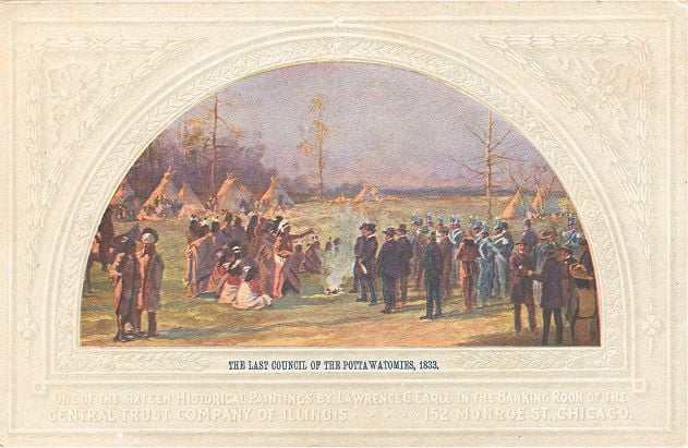
The Black Hawk War culminated in the 1833 Treaty of Chicago, in which the U.S. government took over total control of certain Native American lands west of Lake Michigan, including the Chicago area. The Potawatomi received promises of cash payments and tracts of land west of the Mississippi River.
In 1835, five-hundred Potawatomi warriors gathered in full dress and danced the last recorded war dance in the Chicago area. The majority of the Indians left the area after that. Chicago was incorporated as a city in 1837.
The purpose of these first six installments of this series was to give a very brief historical background as context for the history of Native Americans on the Ridge. We will now turn our attention to the Native Americans who lived on and around the Blue Island Ridge up to the 1830s.
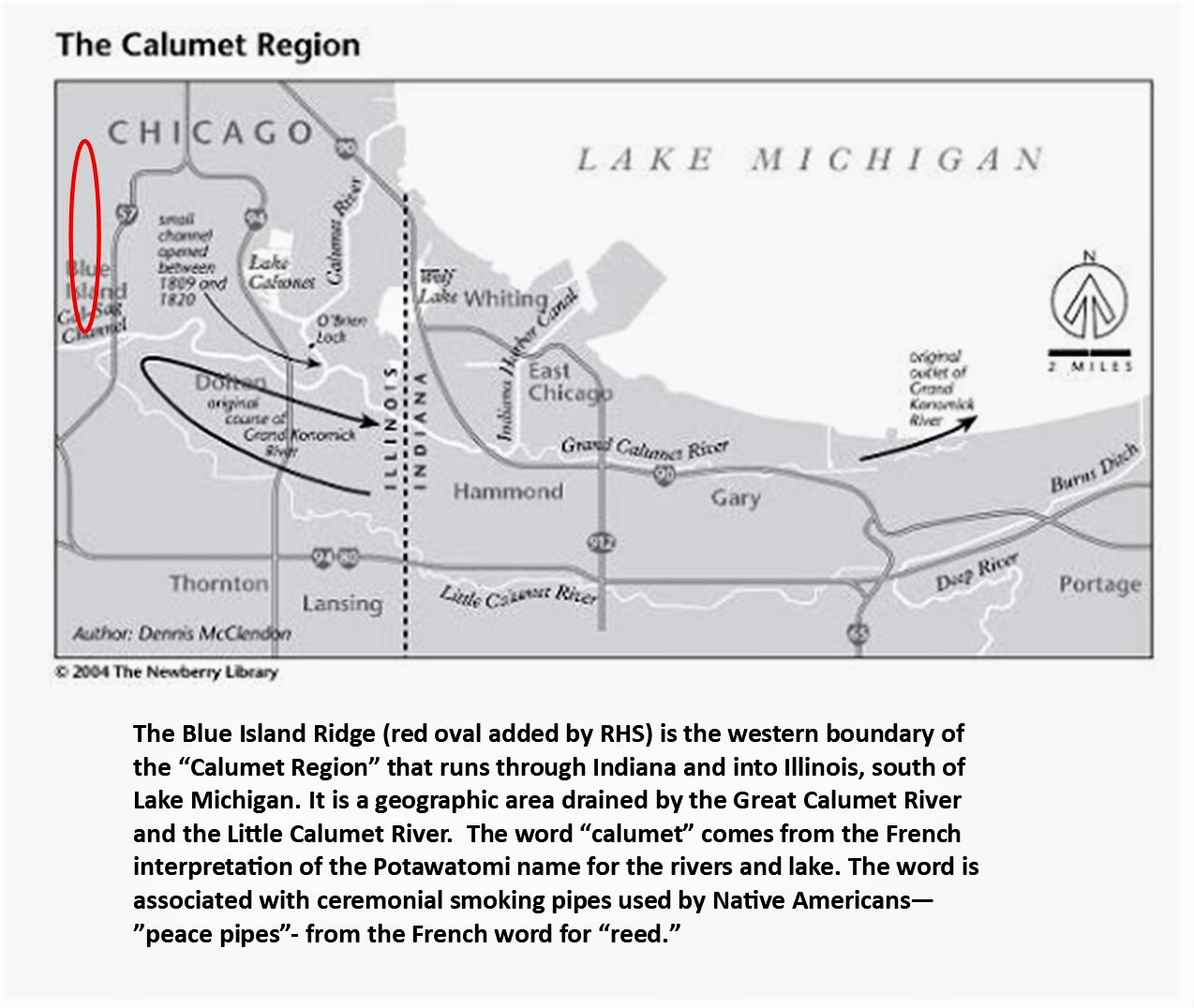
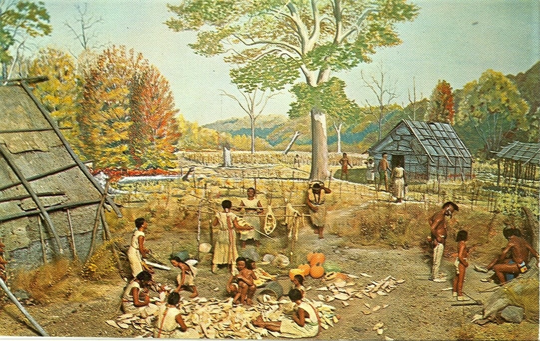
Native Americans and the Blue Island Ridge – Part 7The Calumet Region
The Blue Island Ridge, a prehistoric landmass formed by glacier activity thousands of years ago, and the surrounding land, is part of the Calumet Region at the southern tip of Lake Michigan. The geography of the area made it important for Native Americans and later European settlers for several reasons.
First, there was an abundant supply of fresh water, and the area abounded with a natural diversity of plants and wildlife, especially during seasonal migrations. Included were buffalo and deer and many small species of game animals, and birds and waterfowl. Fur-bearing animals such as beaver, muskrats, and mink were numerous. Bears were in the area, and predators such as wolves, lynx, bobcats, and the occasional mountain lion.
Wild fruit and nut trees and bushes were plentiful – plums, berries, walnuts, etc. Forests of trees, primarily oak, provided wood, and elm and birch bark made good shelters and canoes.
In addition to Lake Michigan, the system of small lakes (Calumet, Wolf) and rivers and streams (the Calumet rivers, Stony Creek) in the southern section of what is now the city of Chicago teemed with fish – trout, white fish, pike, etc.
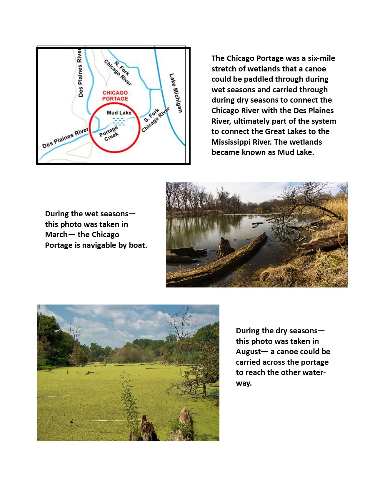
The second important purpose was its vital location for transportation and trade. The system of waterways and seasonal wetlands west of Lake Michigan offered portages between the Great Lakes and the Mississippi River to the west. This was vital in connecting the East Coast to the Midwest, and then the Mississippi ran south all the way to what we call the Gulf of Mexico.
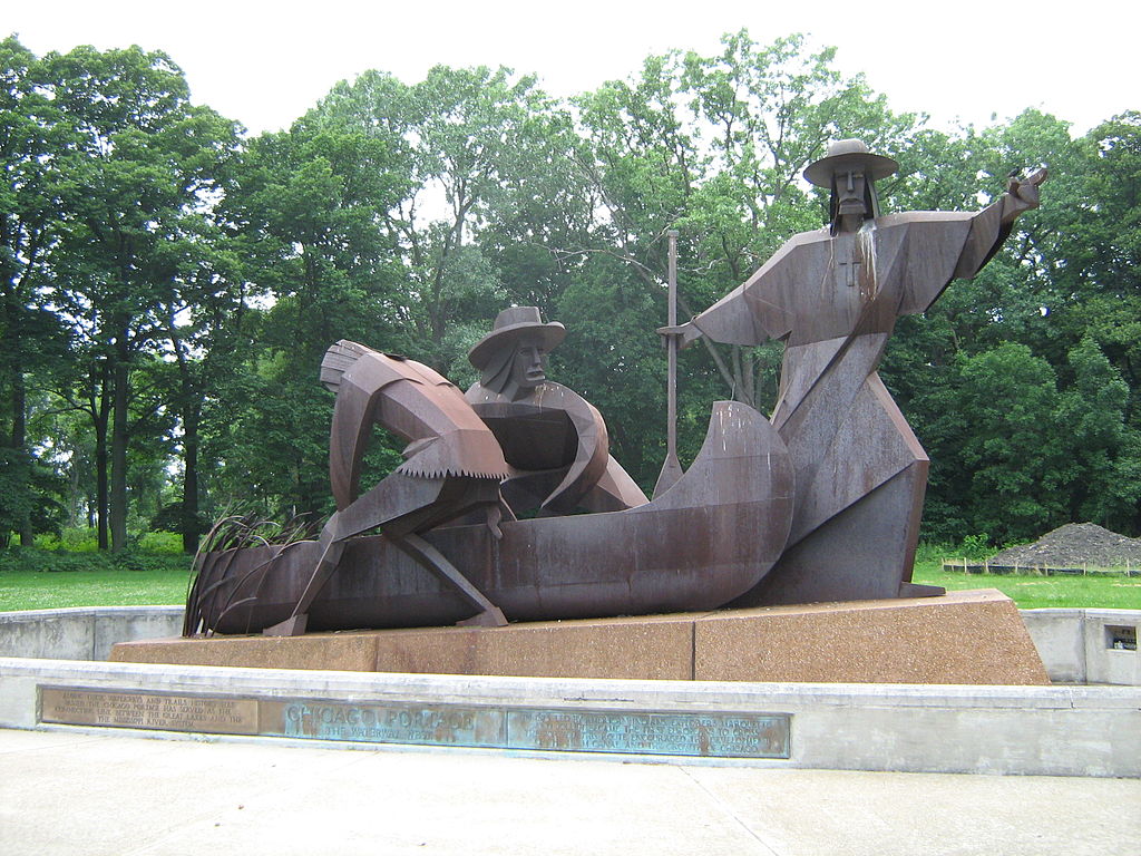
One of the most important early portages was the Chicago Portage.
Also, the Cal-Sag Channel was built to give a boost to other waterways in the system and that will be discussed further in a future post.
In today’s world of air travel, these systems may not seem so important. But in the past, when shipping ruled, long before there were even railroads, a route like the Chicago Portage or the Cal-Sag Channel was very critical.
Of course, the Native Americans knew about the Chicago Portage and used it for thousands of years, and were the ones who showed it to the European explorers. The idea that white settlers “discovered” the portage system is not accurate. They exploited the system shown to them by the Indigenous People to further settlement and development.
And it was a Native American who recommeded the building of the Cal-Sag Channel.
Many overland trails also passed through the area. Geographers have identified seven major trails that ran through the Calumet region, and many smaller trails have been lost to development. Some of the trails intersected right at the southern tip of the island, which is now where Western Avenue crosses the Cal-Sag Channel. Many of these trails developed into major roadways today.
The Calumet region was inhabited by multiple Native American groups, predominantly the Illinois and Miami, who were then replaced by the Sauk, Fox, and Kickapoo, and ultimately the Potawatomi established the dominant presence, and were the major inhabitants in the 1830s when the land was turned over to the U.S. government and the Indians left the area.
An important point to consider is the Native American concept of “land ownership” and we will discuss this in the next section, and begin to explore the life of the indigenous people of the Calumet region, which is incredibly complex and fascinating.
Chicago Landmarks
Everyone will have their favorite landmarks in Chicago to go on a list like this one. And while I agree these are all interesting sites, not all of them would be in my top five.
These would be my choices:
Pullman Historic area – included in the list, definitely one of the most historically fascinating and important areas in the city.
The Chicago Water Tower at 806 North Michigan Avenue.
The Robie House by Frank Lloyd Wright at 5757 S. Woodlawn Avenue.
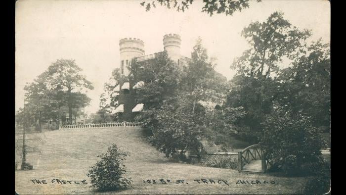
The Givins Beverly Castle at 103rd and Longwood Drive. This is the ONLY castle in the city!
The final one is up for grabs – there are so many interesting places to choose from. Cemeteries like Graceland or Oak Woods. Sculptures like Lorado Taft’s Fountain of Time. Lincoln Park or Grant Park or Jackson Park. The Cultural Center, the Tribune Tower, Sears (Willis) Tower. The old Stockyards Gate. The Haymarket monument. Buckingham Fountain. On and on.
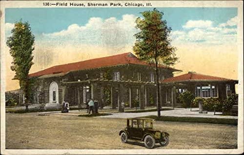
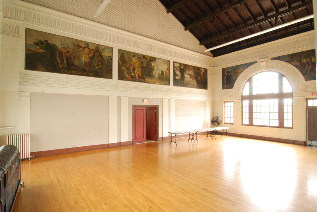
The original list includes a building in Garfield Park. A number of parks have very important old buildings. Sherman Park’s field house was designed by the famous Daniel Burnham. The park is named for Burnham’s father-in-law, John B. Sherman, the founder of the Chicago Union Stockyards. The landscaping was done by Frederick Law Olmsted. In addition, the Sherman Park field house also has priceless murals completed during the 1930s through the Works Progress Administration (WPA). (Sherman also owned much of the land that is now Dan Ryan Woods and used the land for an experimental stock farm. After his death, the land was eventually sold to Cook County for the forest preserves.)
I am not up on industrial design like the bridge they mention in this article, but there are numerous bridges and industrial design elements for people to choose from – I will let others comment on that.
https://kevsbest.com/landmarks-in-chicago/amp/?fbclid=IwAR2pDDA57BWfo9jsJ7QGZRZe1RODUcWADU3mynJNSi8pIcse-sMgKeEPRtU
Native Americans and the Blue Island Ridge – Part 8Relationship to the Land
This series is looking at the history of Native Americans on the Ridge in the context of developing Land Acknowledgement Statements, which are declarations recognizing that Indigenous Peoples lived on this land for thousands of years before the European settlers arrived.
As with every aspect of this topic, the relationship that Native Americans had with the land was complex. Indians were natural environmentalists, stemming from their spirituality. Customs and lifestyles varied from group to group, but in general, the Indigenous people considered the land and all things in nature as gifts from a sacred Creator being or force, and were grateful and humble for these gifts.
In this value system, humans were not masters of the natural world, but rather they were a part of the system like other animals and plants. There were mutual benefits for plants and animals to exist together in an environment. A human being did not exist separately from the air he breathed, or the water he drank, or the plants he ate, or the animals whose furs clothed him, or the bark of the tree that was used to make his canoe.
According to John Low, Ph.D., J.D., a professor at Ohio State University, who is an enrolled citizen of the Pokagon Band of Potawatomi Indians, and was interviewed by RHS:
“Our ancestors lived for thousands of years utilizing the resources around them and securing a balance in their use of the environment. Our traditional teachings emphasize that we are but one part of the Universe and that to live in balance with the other beings of the world we must live in a way that minimizes waste and honors the sacrifices that plants and animals make for our continued existence.
“Our songs, stories and spirituality all teach the ways for us to live in harmony with each other and the world around us.”
Comments from other Native Americans in the past support Dr. Low’s statements:
“Indians and non-Indians alike [must] see ourselves as part of the earth, not as an enemy from the outside who tries to impose its will on it. Because we … also know that, being a living part of the earth, we cannot harm any part of her without hurting ourselves.” – Lame Deer, Lakota medicine man
“The Great Spirit made the flowers, the streams, the pines, the cedars—takes care of them. . . . He takes care of me, waters me, feeds me, makes me live with plants and animals as one of them. . . . All of nature is in us, all of us is in nature.” – Black Elk, Lakota medicine man
Although their efforts were not perfect, the lifestyles of most Native American tribes were excellent examples of sustainability. Some tribes, like the Iroquois, were fierce hunters, but they respected their prey, such as deer and bison, and took care not to overhunt. Other tribes who relied on crops developed elaborate irrigation systems and other practices to keep the land fertile. They cut down trees sparingly.
There is a misperception that Native Americans did not understand the concept of land ownership or personal possessions. This is not true. Different tribes practiced different customs and some had very complex systems and rules concerning possessions.
They certainly established boundaries of tribal lands for hunting, fishing, and growing crops. Within tribes, while they considered the land to be a communal resource, they respected personal boundaries of homes and family plots and possessions. Possessions were something you could take with you – horses, clothing, food, tools, ceremonial items. You could not take the land and nature with you – therefore no one could really “own” it.
What European settlers considered an unsettled, nomadic lifestyle for some Indians was actually not aimless wandering at all. The Indians rotated their living arrangements among several preferred locations to take advantage of seasonal bounties for hunting and harvesting food plants. It was an environmentally efficient way to live. Rather than building permanent structures and fences, and trying to force the environment and land to conform to their needs and wants, they followed the seasons and the plentiful resources available at different places at different times.
Next: The life of the Native Americans in the Blue Island Ridge area.
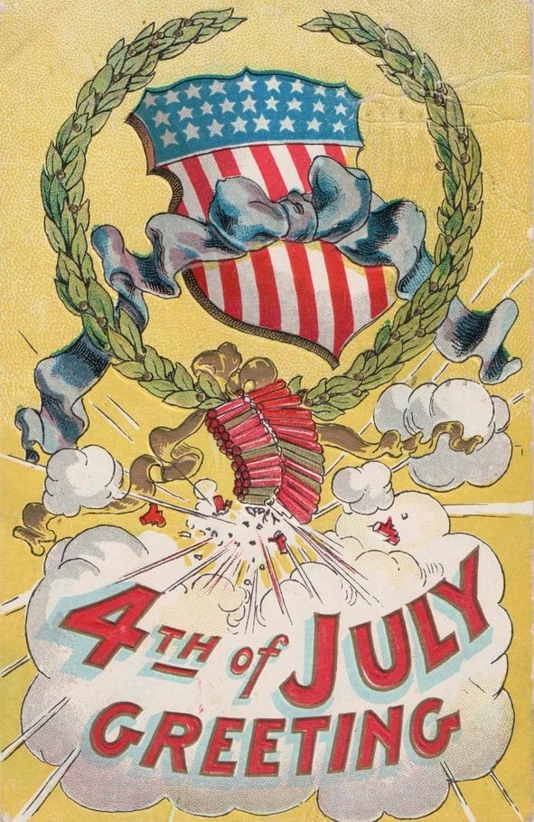
Happy Fourth of July from the Ridge Historical Society!
How did the residents of the Ridge celebrate one hundred years ago? According to the July 8, 1921 Englewood Times newspaper and our intrepid reporter Mrs. Pauline F. Palmer:
“The Ridge enjoyed a corking good Fourth and the field park and swimming pool at 97th Street and Longwood Drive was crowded all day. The baseball games and water sports attracted much attention. Many guests from adjoining suburbs were present and were pleased at the comfortable pleasures enjoyed by all.”
Mrs. Palmer is referring to the original Ridge Park, which was established in 1911 – 12. The architect John Todd Hetherington, who designed many fine homes in Beverly and Morgan Park, was a member of the Ridge Park commissioners. The board persuaded Hetherington to design the park. His creation included a small field house, outdoor swimming pool, running track and sports fields, surrounded by trees, shrubbery, flowers and walks.
In 1929, Hetherington, now in partnership with his son Murray D. Hetherington, designed the current field house, which enclosed the pool, and used the original fieldhouse as the auditorium.
And in case anyone thinks that porch and lawn concerts are anything new, because of the pandemic, that is not so.
Mrs. Palmer also reported that for the holiday one hundred years ago:
“About one hundred guests enjoyed the out-door street dance and sing at 94th Street and Pleasant Avenue, given by Miss Edna Wiggins of 9372 Longwood Drive on Tuesday evening. A four-piece orchestra furnished the music and the young people all enjoyed the novel way in which the party had been planned. Mr. and Mrs. A. B. Christian, 9300 Longwood Drive, and Mrs. Mitchell of Memphis, Tennessee, chaperoned the dance. Refreshments were served.”