
Explore the RHS Facebook Archives, a rich repository of local history written by Carol Flynn. For two decades, Carol brought a deeply dedicated voice to public education at RHS. Her role as Facebook administrator through mid-2025 naturally extended her prolific research into meticulously detailed articles, most notably her multi-part historical series posts. Today, Carol continues her local history writing for The Beverly Review and other outlets.
2021
The Ridge Historical Society
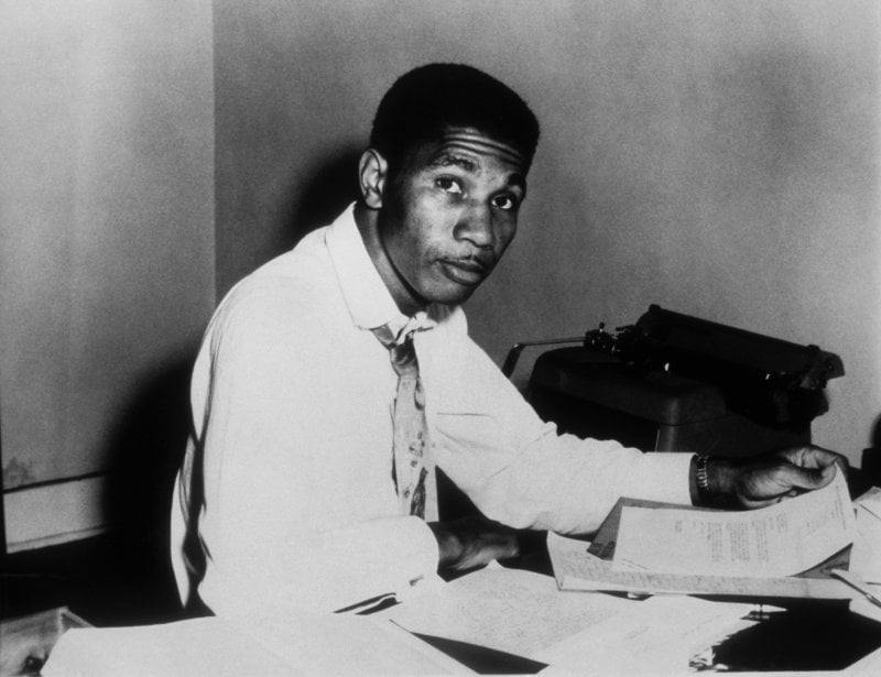
School Series – Profile 13: Medgar Evers
Carol Flynn
As the new school year begins, we will continue to run profiles of the people for whom schools in the Ridge communities are named.
Medgar Wiley Evers (1925-1963) was a civil rights activist in Mississippi who worked to end segregation and expand opportunities for African Americans, including the enforcement of voting rights.
Evers was a World War II veteran who served in the segregated U.S. Army, rising to the rank of sergeant. His unit participated in the D-Day invasion of Europe.
Returning home, he was forced away at gunpoint when he tried to exercise his right to register to vote in Mississippi.
He attended Alcorn College on the G.I. Bill, majoring in business administration. He was an honor student and president of the junior class. He competed on the debate team, sang in the school choir, and participated in football and track.
He worked as an insurance agent under a man who was a leader in the Regional Council of Negro Leadership (RCNL), a civil rights and pro-self-help organization. Involvement in the RCNL gave Evers crucial training in activism.
When his application to the University of Mississippi Law School was rejected due to a technicality, he approached the National Association for the Advancement of Colored People (NAACP) for help. Impressed with the young man, the NAACP offered him a position as the organization’s first field secretary in the state. Evers accepted, opening an office in Jackson, and nearly doubled NAACP membership to 15,000 within three years.
As a field worker for the NAACP, one of his first assignments was to investigate the murder of Chicagoan Emmet Till, the 14-year-old African American boy kidnapped and murdered for flirting with a white woman in 1955 in Mississippi. Evers helped locate and protect witnesses.
In 1961, Evers was sentenced to 30 days in jail and fined $100 for speaking out against the sentence handed down to a young Black man who stole several bags of chicken feed. Evers appealed his own conviction all the way to the Mississippi Supreme Court, which surprisingly found in Evers’ favor. The court was lauded for “courageously deciding the case in accordance with the law of the land,” something that was recognized would not have happened even a few years before. The Chicago Tribune declared, “The time is not yet here but it is approaching when Negroes in the deep south can look with growing confidence to the state courts as well as the federal courts to equality before the law and protection of their rights as citizens.”
Evers was part of the movement to integrate the University of Mississippi in 1962, which led to President John F. Kennedy sending in 30,000 National Guardsmen to stop the riots that started when Blacks tried to register for classes.
In 1963, Evers was elected to the board of the American Veterans Committee (AVC). He was scheduled to receive the group’s meritorious achievement award at its annual convention in Washington, D.C., but he was arrested in Jackson, Mississippi, and charged with a felony, restraint of trade, for picketing for desegregation of public places. The AVC attendees instead took up a collection of money to send to Jackson to “keep courageous children safe and well.”
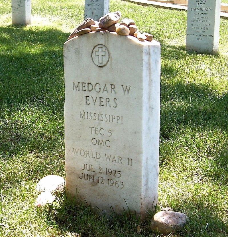
After nine years of civil rights and voting registration work, several attempts to kill him, and numerous death threats, Evers was assassinated outside his home by a white supremacist in June 1963. At first, the hospital refused him admittance because he was Black. His wife and young children pleaded while he bled to death in the car. The hospital admitted him, but he died within an hour. He was 37 years old.
Evers had spoken at an integration rally the night before. Over 700 African American citizens were arrested that month alone in his area for protesting for the end to Jim Crowe laws which enforced racial segregation in the military, public places, schools, transportation, federal workplaces, restaurants, drinking fountains, and restrooms, creating institutionalized economic, educational, and social disadvantages for many African Americans living in the United States. Hundreds more were arrested when they attempted to march after Evers was killed. African Americans were rounded up for trying to enter whites-only restaurants and picketing other places and taken via garbage trucks and other means to campgrounds put aside for their holding which were declared no better than concentration camps. African Americans were not allowed positions on police forces in Mississippi in the 1960s.
Rewards for information on Evers' killer/s were offered by the city of Jackson, the NAACP, the United Steel Workers Union, local newspapers, and other groups. U.S. Attorney General Robert Kennedy assigned FBI agents to track down the sniper. However, Evers’ murderer was tried and released twice by white juries in the 1960s.
It took until 1994 for a racially mixed jury to find the murderer guilty and sentence him to life in prison.
Evers stated in 1960: “Threats sometimes frighten me, but I’m going to continue the work even if it means making the ultimate sacrifice.” He made that sacrifice. Evers was buried in Arlington National Cemetery with full military honors. Over 3,000 people attended the ceremony. However, his legacy is not his death, it is the many positive contributions he made to advancing rights for all people.
The Medgar Evers School at 9811 S. Lowe Street opened in 1969.
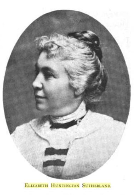
School Series – Profile 14Elizabeth “Bessie” Huntington Sutherland
The next person to be profiled in our series about people for whom Chicago Public Schools on the Ridge are named is Elizabeth “Bessie” Huntington Sutherland (1851 – 1924).
Bessie Sutherland was a very respected and forward-thinking leader in the education field.
She was born in 1851 on the Ridge. Her parents, Samuel and Maria Robinson Huntington, were part of the earliest Ridge pioneer families. Samuel was a farmer and kept stock and also became involved with the railroads, and served as sheriff of the City of Blue Island. Maria was reputed to have been an early teacher in Blue Island, making $1.00 per week for her efforts.
Around 1854, a two-room schoolhouse was built in Blue Island, and it is probable that Bessie attended this school as a child. She went on for training as a teacher at the Cook County Normal School, established in 1867. The name “normal school” was used for teacher preparation programs because they established teaching standards or “norms.” Bessie graduated from this school in 1869. This school eventually evolved into Chicago State University.
Bessie’s career as a teacher included the Blue Island school and the Hyde Park high school. She took graduate classes at the University of Chicago. She was a member of the National Education Association.
The Washington Heights public school started in 1874 and Bessie became principal there in 1883, the first woman to be named a principal in Cook County. In 1893, this school was renamed the Alice L. Barnard School, after another Ridge native who had become the first woman principal of a Chicago school.
A 1912 History of Education in Illinois reported that Bessie had three schools under her charge, nineteen teachers, and eight hundred students.
Bessie became a teacher during the “Progressive Era,” that time of significant reform. The field of education made great advances during this time, as the philosophy of learning changed from rote memorization to exploration and experimentation. Bessie surely knew two of the movement's leaders in Chicago, Francis W. Parker, who became head of the Cook County Normal School, and John Dewey, who established the University of Chicago Laboratory School.
An anecdote about Bessie illustrates the Progressive educator. While principal at the Barnard School, one day she heard that a camel had escaped from a traveling show and was freely roaming the local woods. She gathered the entire student body and led an impromptu field trip to the woods to observe the camel “in the wild” and share a lesson on animals of the world.
Bessie was a strong proponent of kindergarten, a unique program that developed in Europe separate from the traditional grade school model. This new model, which emphasized investigation and imagination, was just starting in U.S. schools in the late 1800s.
Bessie started a program at the Washington Heights School, and is quoted in a 1900 publication, Education in the United States, that when comparing siblings from families where the older children went through school before the kindergarten program was started, the younger siblings who had the advantage of kindergarten “were brighter in every way,” which she attributed to the “early wholesome awakening brought about by the training of the kindergarten.”
[RHS did an entire newsletter in the past on kindergarten and the pioneering educators in this area who lived on the Ridge, the Hofer family, and will run a series on this in the future.]
Bessie authored professional articles, including one on a county-wide spelling contest for the Journal on Rural Education. However, in a literature search, several articles about crime are attributed to her that were actually written by another E. H. Sutherland, Edwin H., a U.S. sociologist and criminologist.
During Bessie’s lifetime, women teachers were not allowed to marry if they wished to remain employed. It was believed that married women teachers would put their energies into their home and the classrooms would suffer.
Bessie put off marriage to David Sutherland until her 43rd birthday in 1894. Sutherland, seventeen years Bessie’s senior, was a real estate developer with considerable property on the south and west sides of Chicago. They made their home at 1638 West 103rd Street. The couple had no children, and David died in 1904. A favorite niece and her family made their home with Bessie.
Bessie kept her employment during her married years. She served as the “lady principal” of Barnard School for almost 40 years. She resigned in 1923, and died in 1924. She was buried in Mt. Greenwood Cemetery.
In 1925, the new school built at 101st and Leavitt Streets was named in her honor.
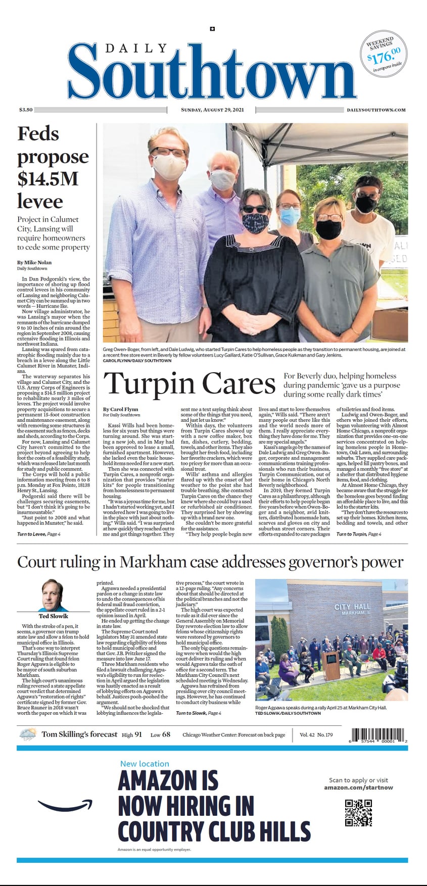
History is made every day. Some of the stories we will remember from the COVID days are of the people who went out of their way to help others. Today we recognize the folks of Turpin Cares.
Native Americans and the Blue Island Ridge – Part 14Native American Sites Around the Blue Island Ridge
This is a continuation of the series on the historical presence of Native Americans on and around the Blue Island ridge. The purpose of the series is not only to educate the community but also to help those organizations developing Land Acknowledgement Statements.
At the time white settlers arrived on the Ridge, the land was primarily being used by the Potawatomi people. The land had been used before that by other tribes – the Miami, the Illinois Confederation, the Sauk, the Fox, and the Kickapoo.
There were documented Native American sites around the Blue Island Ridge. There were also stories about Native Americans in the area in oral and written histories.
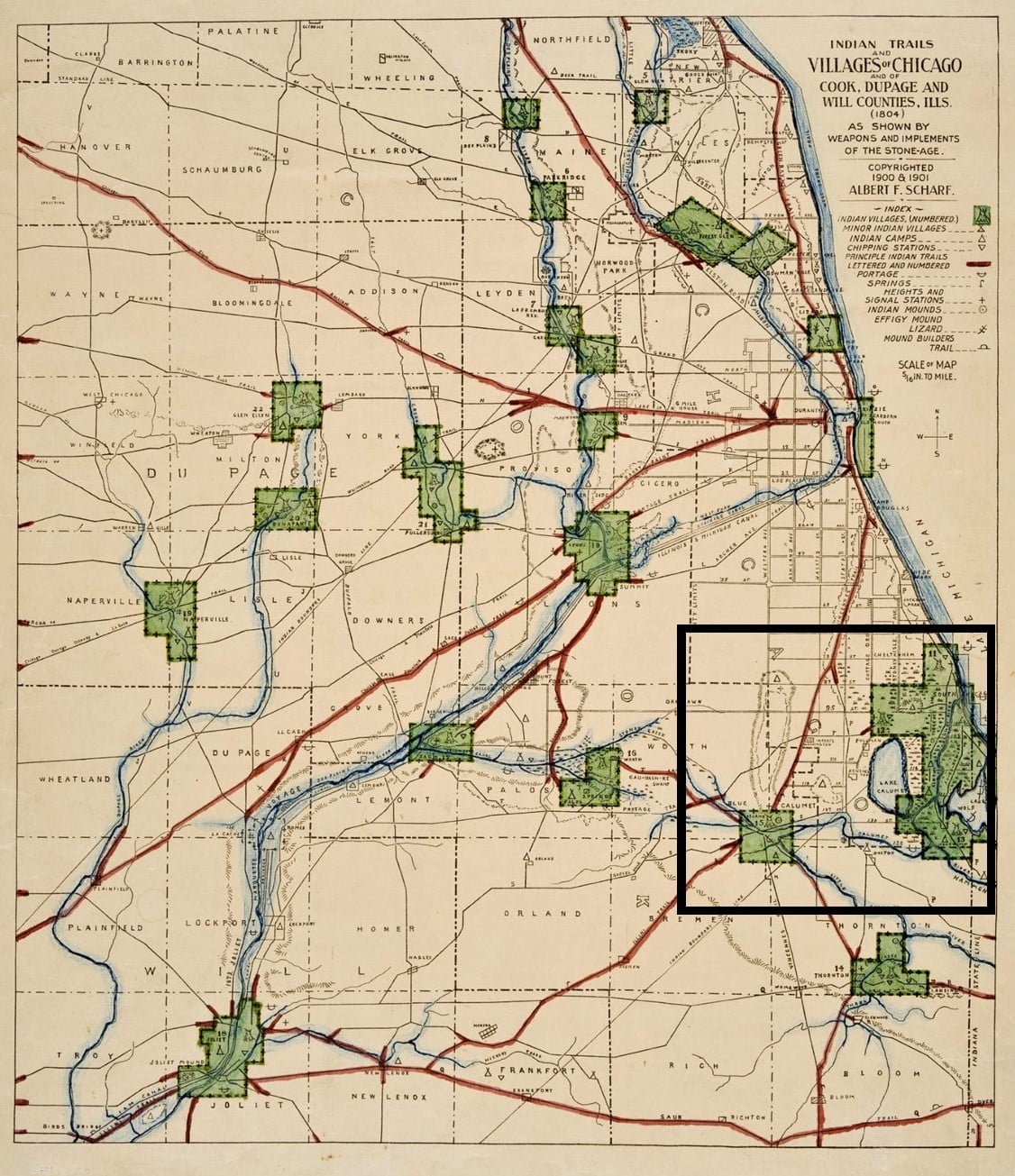
A map from 1804, reproduced and updated in 1900, shows the early Native American trails and villages of the Chicago area, and surrounding counties. Washington Heights and Blue Island are delineated, and the Blue Island is outlined.
On the full map, the Blue Island Ridge area is marked by the black square. The legend of the map shows the symbols. The vast wetlands between the Ridge area and Lake Michigan are evident on the map.
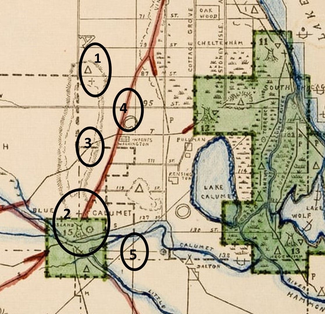
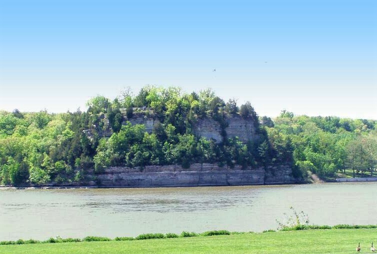
On the close-up of the map, the northern tip of the Ridge, roughly 87th Street and Western Avenue, is identified as number 1. This land is now included in the Dan Ryan Forest Preserve of the Forest Preserves District of Cook County (FPDCC). An Indian camp and signal station are shown there. The Ridge area is the highest elevation in Chicago, about 60 feet higher than downtown Chicago. From here, the surrounding territory could be observed for many miles around, all the way to “downtown” where Fort Dearborn stood, 12 miles to the northeast.
There are no other designations on this map for an Indian establishment on the top of the Ridge. There is some mention of an early map that includes the word “manitou” on the top of the Ridge. In general, because there are many Native American groups with varied beliefs, the Indigenous Peoples believed in a Great Creator, and they interacted with the Creator through spirits called manitous. Each individual had a personal manitou, and there were also manitous that resided in natural objects, such as the sun, trees, and rocks, that helped everyone. It would be consistent that a unique table of land like the Blue Island Ridge housed a manitou.
The southern end of the Blue Island is designated as number 2, where there was a major Indian village on the Stony Creek. The creek at that location is now part of the Cal-Sag Channel. There is also a circle that shows there was an Indian mound there, which likely was a burial site.
The mound builders were actually in the historic period before the Pottawatomi so this shows it was a Native American site for a long time. Another old document mentioned Native American “cemeteries” in Blue Island and to the east, but reported they “vanished” with time. Mounds in the Calumet region in Indiana were destroyed for farmland and this likely happened here also.
A portage trail is shown as number 3 on the map. This ran across the top of the Ridge, an overland route connecting the waterways to the east to the Stony Creek. It ran along what is now about 103rd Street. Portages were used to carry canoes overland where there were dry gaps between waterways.
The Vincennes Trail is marked by number 4. The Vincennes Trace or Trail, a major trail originally formed by migrating buffalo that was well known and used by Native Americans and later by European traders and settlers, ran through Kentucky and Indiana, and into Illinois. It was named the Vincennes Trail by white traders because a major location on the trail was Vincennes, Indiana, a city founded by French fur traders on land inhabited for thousands of years by Indigenous People.
In Illinois, the trail ran south of the Blue Island Ridge, and a branch split off, heading north/south to/from the area which became known as Chicago. Parts of the original trail became Chicago’s State Street and Vincennes Avenue.
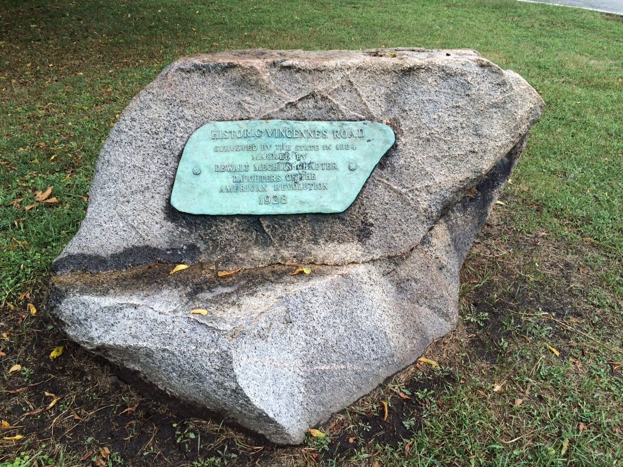
This branch that ran north/south to the Chicago area had two paths – one ran along the top of the Blue Island Ridge and a second path ran on the east side below the Ridge. A marker at 91st Street and South Pleasant Avenue indicates the original path, now lost, on top of the Ridge. The lower path eventually evolved into today’s Vincennes Avenue.
The southern Indian Boundary line mentioned previously, established in 1816, is number 5 on the map. There were two boundary lines – a north and a south one. The land in between the two lines defined the territory that could be used by settlers, and the land outside the boundary lines defined the territory that could be used by the Native Americans. The southern Indian Boundary Line was established running diagonally from the northeast to the southwest, passing just below the southern tip of the Ridge, thereby including the Ridge in the settlers’ territory. The land to the east and south of the line was for Native American use.
Next post: Other stories about the Native Americans on the Ridge.
Native Americans and the Blue Island Ridge – Part 15Native American Stories and Artifacts on the Ridge
The known sites connected with Native Americans on and around the Blue Island Ridge as indicated on an 1804 map were covered in the last post.
Most of the Native Americans left the Chicago area in the 1830s. Some stayed, of course, and there were even exceptions to the treaties that allowed some chiefs and their groups to remain in certain locations. Some returned annually for a while to their summer home grounds. But they were no longer a dominant presence in the area.
The white settlers who followed the Native Americans recorded various versions of “history” and found artifacts. These are a few of the more interesting stories.
John H. Volp shared a number of stories about the Native Americans in the Ridge area in his book “The First Hundred Years – 1835 to 1935 – Historical Review of Blue Island – Illinois.”
He reported that the Native American villages and sites at the southern tip of the Ridge (called Blue Island and Wildwood to the immediate east, now a part of the City of Blue Island) were the site of a battle in 1769 between the Ottawa and Potawatomi against the Illinois Confederation. The story goes that the Illinois people were ultimately driven to the landmass that became known as Starved Rock, where they were surrounded and isolated, and most of them perished from starvation. This removed the Illinois people from the Chicago area. However, as much as the story of Starved Rock has appeared in Illinois historical lore, researchers today doubt its accuracy. The story has passed down through oral means but there is no other documentation to support it.
Local histories in the Ridge Historical Society collection include reports that early settlers found many Native American artifacts in the area. Postholes were reported being found in the 1840s at what is now the east side of Hale Avenue, between 104th and 105th Streets, and stone tools were found in the area.
The History of Cook County published by A. T. Andreas in 1884 includes this entry: “The neighborhood of Washington Heights also claims some archaeological importance. Since 1859 the members of the Barnard family alone have collected 36 flint arrow-heads, two battle axes, a spearhead, several pieces of ancient pottery, and other evidences of the former savage residents. The remnants of pottery were found in a small mound surrounded by large cobble-stones, and embraced, as it were, within the roots of a small oak tree which sprang up from the mound.”
The location and significance of this mound are not known.
One clarification of local folklore needs to be addressed, concerning the Hopkinson-Platt House at 108th and Drew Streets. The house was built in the 1870s, and Dr. Robert and Mrs. Harriet Platt moved into the house in the 1920s. Dr. Platt (1891-1964) was a geography professor at the University of Chicago, and Mrs. Platt (1899-1979) traveled with him, and also tended to the many foreign students and refugees they invited to live with them.
Mrs. Platt claimed an oak tree in the yard of the house was 800 years old and was the site of Native American councils. She called it the “Council Oak” and there is a plaque installed in the yard. The tree blew down in a storm in 1988.
Whether or not the tree was a “council oak” cannot be verified. That species of oak tree has only about a 200-year lifespan, 300 years at best, not 800 years. That means it was old enough to be growing at that spot during the time of Native Americans prior to 1833, but it would have been a younger tree, and there would have been older and bigger trees for use for council meetings.
The land included with that property has never been developed and excavation would be very interesting.
Native American sites are being excavated in the forest preserves surrounding Chicago, the only land that has not been totally lost to development. In the area of the Ridge, excavation was reportedly going on at an undisclosed location in the Joe Louis Golf Course, which is located in the Whistler Woods Forest Preserve, along the Calumet River, just southeast of the Ridge.
Next post: Captain Billy Caldwell aka Chief Sauganash
Native Americans and the Blue Island Ridge – Part 16Captain Billy Caldwell aka Chief Sauganash
While there is documentation of Native American sites all around the Blue Island Ridge, no historical records have been located that identify individual Indians who lived in the area. However, there are references that the area was frequented by Captain Billy Caldwell, also known as Chief Sauganash, a notable figure from Chicago’s earliest days.
Caldwell was born in the early 1780s near Fort Niagara in New York, from a marriage between a high-ranking Native American woman, variously identified as Potawatomi or Mohawk, and a Scots-Irish officer in the British Army during the Revolutionary War. This type of union was not uncommon, but such marriages were rarely recognized as “legitimate” in the white community. Caldwell’s father later settled in Canada, married a white woman from settler stock, and raised a white family. Billy was taken to live with the white family and received formal education. He forged his own life and left Canada after his father’s death.
Caldwell was commissioned as a captain in the Indian Department of Canada during the War of 1812. He made his way to Chicago where he was accepted by the local Potawatomis and he befriended the earliest white settlers. The name Sauganash was given to him by the Indians, loosely translated as “one who speaks English.” He was known to the European traders and settlers as the “Irish Indian.” He was well respected, referred to as Captain Caldwell. Being well-educated and speaking English, French, and several Native American dialects well, his services as a guide and translator were often sought out.
Although his life story is rich, we will only concentrate on Caldwell’s known involvement with the Blue Island Ridge.
According to James Bucklin, chief engineer of the I & M Canal project, Caldwell originated the idea of the Cal-Sag Channel. A passageway between the Great Lakes and the Mississippi River had long been sought. The I & M Canal was built to connect the Chicago River to the Illinois River as one leg of the journey. Feeder canals were built to keep water flowing into the canal, and one came from the Calumet River in Blue Island. Bucklin wrote in a report referring to the 1830s: “From Billy Caldwell, a half-breed with some education and great intelligence, who had explored the country in every direction, I often procured valuable information during my exploration. It was he who first suggested making a feeder of the Calumet River.”
Caldwell helped survey the Vincennes road in 1832-33. This was the earliest road that ran through the Blue Island area and connected Chicago with trading posts to the east.
A recounting of a survey party by J. P. Hathaway, Jr., dated July 23, 1833, documents just one visit to the Blue Island by Captain Caldwell others. They found a log house on the Ridge, and the owners not being home, milked the cows and made dinner with ham and bread. They continued south to Stony Creek, at the southern tip of the Blue Island, “a delightful place, commanding a view of thousands of acres of prairie and patches of timber. At this point, there were Indian graves.”
They forded the creek in the area around what is now Western Avenue. Later, returning north, they decided to recross opposite their first encampment. However, the horse got away and their wagon was swamped, and they lost most of their provisions. Continuing north, they found the folks of the log cabin at home, and purchased a pan of milk for supper. They spent a wet night on the ground, keeping the fire going all night. They were back in Chicago by eight o’clock the next night “with keen appetites for regular living again.”
In 1870, John D. Caton, a lawyer and judge on the Illinois Supreme Court, read a paper before the Chicago Historical Society on “The Last of the Illinois, and a Sketch of the Pottawatomies.” In this first-person account, he related, “…[W]hen riding over the prairie south of Blue Island, in 1833, with Billy Caldwell, … the old chief as usual was answering my questions about the past and what portion of the country he had visited. …[H]e commenced giving an account of an expedition of the British from Canada across to Ohio, of which he and a number of his warriors formed a part ….”
Caldwell was instrumental in negotiating the 1833 Treaty of Chicago that led the Potawatomi to peacefully leave the area. He moved with them to Council Bluffs, Iowa, where he reportedly died in the early 1840s, although his gravesite is not known.
Both his white and Indian names grace locations around the Chicago area, including Caldwell Woods, Billy Caldwell Golf Course, Caldwell Avenue, the Sauganash neighborhood on the North side, and Sauganash Park.
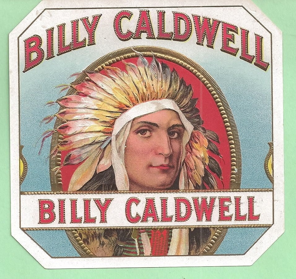
There are no photographs to be found of Billy Caldwell. There were some sketches and paintings done after his death. This likeness was invented for a cigar brand made by a Chicago company. From the collection of C. Flynn.
The tobacco and cigar industry was very important in the past. By the 1860s, there were more than 200 cigar makers in Chicago. By 1900, there were over 40,000 cigar makers in the country. Many of these were small operations out of homes. But the numbers started to decline in the 1930s for several reasons – the Great Depression, increased use of machinery replacing hand-rolling, rationing of tobacco during World War II, the release of cancer studies, and the embargo on doing business with Cuba which led many cigar makers to leave the country.
Next: Native Americans after the 1830s
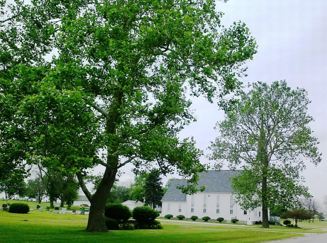
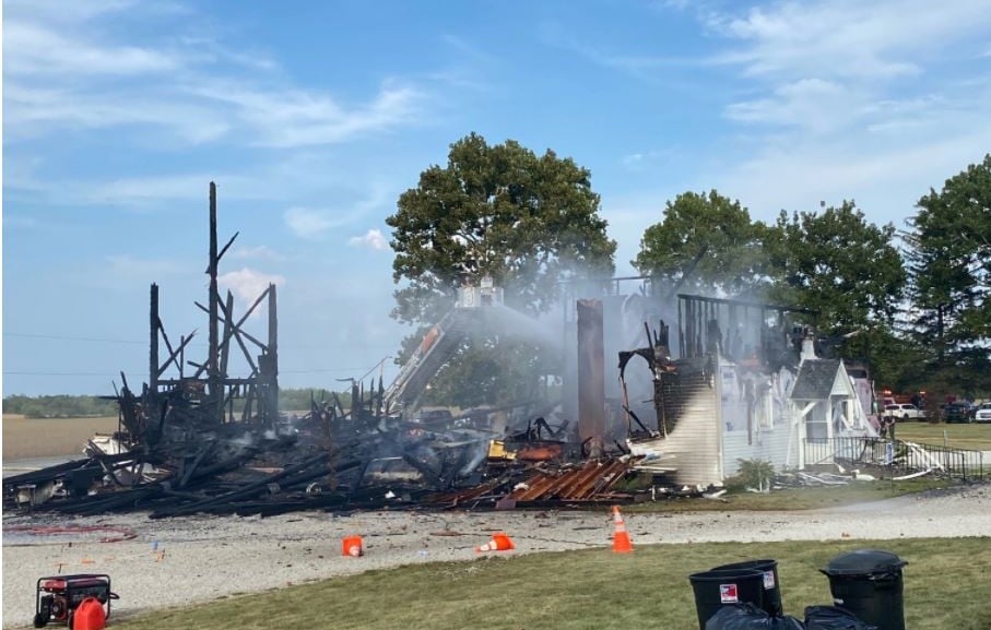
The Ridge Historical Society mourns the loss of a historic church to the south of us, St. Paul's Lutheran Church in Beecher, Illinois, along the old Dixie Highway. The church was destroyed by fire yesterday.
This church was featured in the movie "Road to Perdition" with Tom Hanks and Paul Newman, and was a site on the annual Drivin' the Dixie tour.
Native Americans and the Blue Island Ridge – Part 17Native Americans after the 1830s
According to John H. Volp in his book “The First Hundred Years – 1835 to 1935 – Historical Review of Blue Island, Illinois,” many young Native Americans started moving west before the 1830s, and most of the Native Americans left the Chicago area in 1835. However, some of those living around the Blue Island Ridge clung to their ancestral grounds until 1847, when a caravan of thirty-five to forty wagons departed the area.
Up until the 1860s, some returned to visit their seasonal homes. In 1835, the Potawatomi who left Chicago moved to Council Bluffs, Iowa. From there, some migrated to Wisconsin and Michigan.
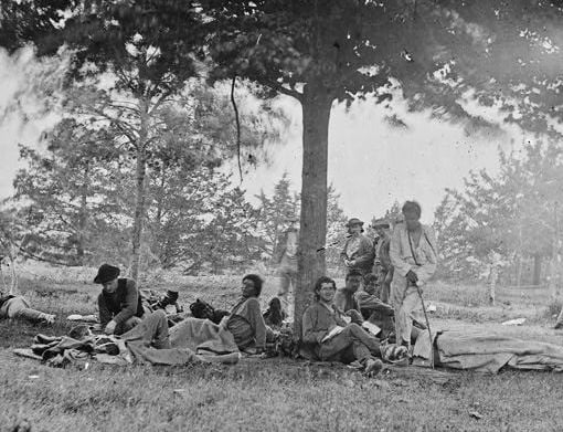
Native Americans fought on both sides of the U.S. Civil War. The most famous Native American unit in the Union army in the east was Company K of the 1st Michigan Sharpshooters. Most of this unit were Ojibwa, Ottawa, and Potawatomi – the Council of Three Fires. There is a likelihood they included Indians who had lived in or were descended from those who had lived in Chicago.
Company K was known for its marksmanship and strategic fighting capabilities. The Indians taught the white soldiers how to camouflage themselves and infiltrate the enemy. They were highly esteemed for their service.
Native Americans had a presence at the 1893 Chicago World’s Fair, also known as the Columbian Expedition. Many of the exhibits that involved Native Americans that were staged by whites, including the independent Buffalo Bill Cody’s Wild West Show, portrayed negative stereotypes of American Indians as primitive, savage aggressors.
However, several Native American groups used the Fair to represent themselves, their cultures, and their handiwork. The Inuit people set up their own village outside of the fairgrounds, and the Navajo weavers made decent money selling their rugs. Other tribes also sold work to collectors.
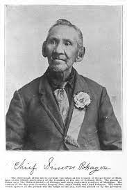
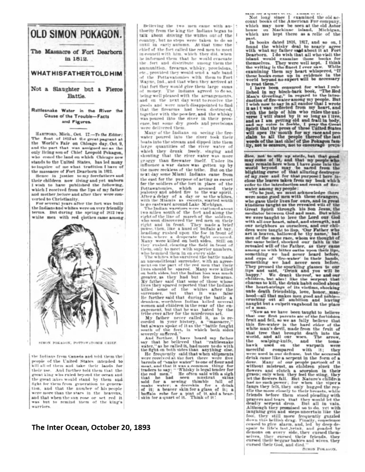
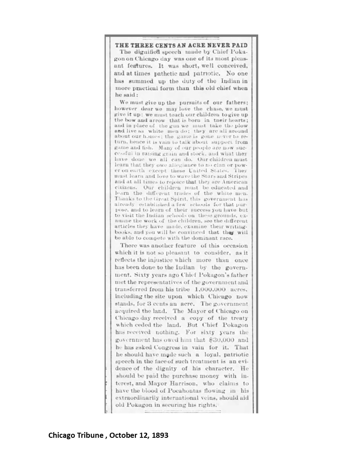
Simon Pokagon, the chief of the Pokagon Band of Potawatomi Indians in Michigan, was a celebrity at the Fair, popular with the high society of Chicago. He was an author and activist trying to get the U.S. government to honor the treaties that had been signed with Native Americans. He gave a speech to 75,000 people that was published in the Chicago Tribune.
Pokagon began pressing land claims to the lakefront on behalf of the Potawatomi people. The area in question was the section known as Streeterville, built on landfill. The land claims were carried on after Pokagon’s death in 1899, but the U.S. never recognized any ownership of that land by Native Americans.
While there were always Native Americans in Chicago, the Indian Relocation Act of 1956 brought Native Americans back to Chicago in significant numbers. The intent of this law was to encourage Native Americans to leave reservations and their traditional lands and assimilate into the general population in urban areas. The tribal status of numerous groups was terminated at this time.
Chicago was an obvious relocation city, supposedly offering employment, education, and housing opportunities. However, Native Americans across the country quickly learned that not only were the opportunities not there, they faced discrimination in employment and housing. The American Indian Center was founded in Chicago to provide both social services and a gathering place for people faced with drastic life changes.
Today, it is reported that 65,000 Native Americans representing 175 tribes live in the greater metropolitan area of Chicago. The majority lives on the North Side.
As for Native Americans in the Ridge communities, depending on the source, the population of Native Americans or “Other” which includes Native Americans is less than 1%. One source lists 0% for Mount Greenwood and Washington Heights, 0.4% for Beverly, 0.9% for Morgan Park, and 0.8% for Blue Island.
Many Native Americans intermarried with other nationalities and may identify with other groups on census forms. The people of Native American heritage in Ridge communities who have introduced themselves to the Ridge Historical Society are of mixed-race background and assimilated into mainstream business and society, and also celebrate their Native American roots.
Next post: Conclusion, Land Acknowledgement Statement for the Ridge
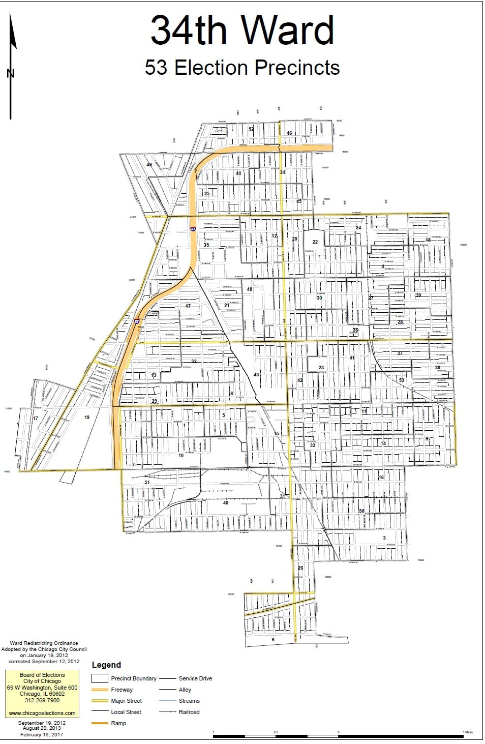
The History of The City Wards in The Ridge Communities – Part IThe Current Picture
As we wrap up one series, the Native Americans on the Ridge, we will also start a new one on the history of the city wards on the Ridge. This series will not be posted on other pages – readers who are interested in this topic are encouraged to follow the Ridge Historical Society page.
“Redistricting” is one of the hot topics in Chicago politics right now, so it’s the perfect time to look at the history of the city ward system in relationship to the neighborhoods that RHS covers. We will start with a review of the situation as it stands today.
The City of Chicago is divided into 50 legislative units called wards. The voters in each ward elect an alderman every four years to represent them on the Chicago City Council, the legislative branch of the city government. The presiding officer of the Chicago City Council is the Mayor, currently Lori E. Lightfoot, and the City Clerk of Chicago, currently Anna M. Valencia, is the secretary. The aldermen elect a President Pro Tempore from within their ranks to serve in the absence of the Mayor. This position is currently held by Brendan Reilly, the alderman of the 42nd ward.
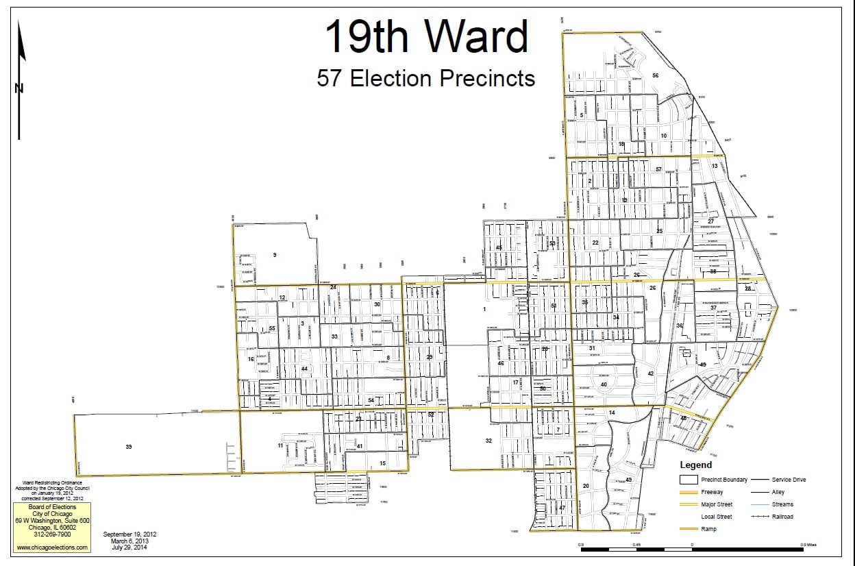
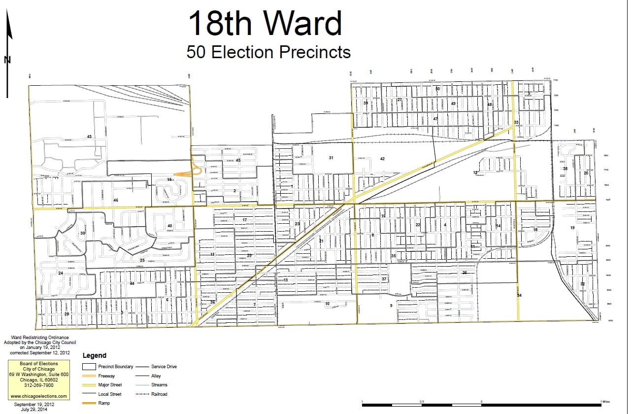
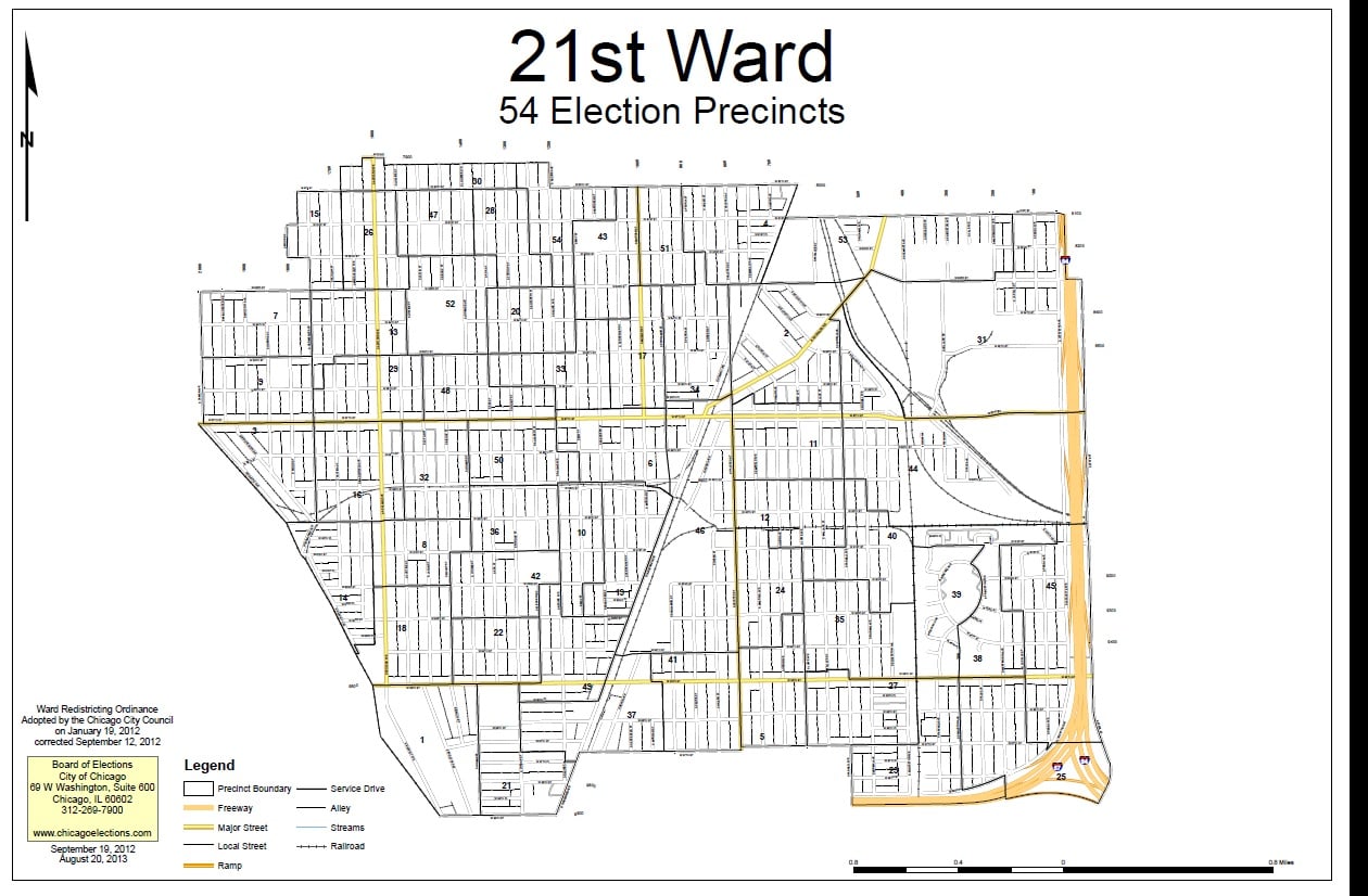
The historical communities represented by the Ridge Historical Society, that is, Washington Heights, Beverly Hills, Morgan Park, and Mount Greenwood, currently fall into four wards – 18 (Derrick G. Curtis, alderman), 19 (Matthew O’Shea, alderman), 21 (Howard Bookins, Jr., alderman), and 34 (Carrie M. Austin, alderman). All of these aldermen are up for re-election in 2023.
Establishing wards and deciding their boundaries have always been intense political exercises in Chicago. The City redraws the ward map every ten years based on population changes reported in the U.S. Census. The goal is to have fifty wards of roughly the same number of residents. Ward boundaries are different from “neighborhood” boundaries, police districts, school districts, etc. All of these geographical – really, geopolitical – divisions are arrived at separately.
If 41 of the 50 aldermen approve a new ward map by an official vote of the City Council, then there is no public referendum on the issue. If no map gets this required support, then voters decide between competing proposals.
Next post: The Origins of The Ward System
National Gold Star Mother’s and Family’s Day
Sunday, September 26, the last Sunday in September, is National Gold Star Mother’s and Family’s Day. On this day, we recognize the women whose sons and daughters died during or because of active service in the U.S. military.
The Gold Star designation started during World War I. Families with members in the service displayed a service flag in their windows. A blue star meant that the person was in active service. The entire community mourned if the star was changed to gold, signifying that person had died. By the time the war ended in November 1918, over 110,000 Americans had lost their lives.
Gold Star Mothers joined together to raise funds to help other Gold Star Mothers, some of whom, dependent upon their sons for their living, were left destitute with their loss. Gold Star Mothers also helped servicemen returning from Europe. The Chicago Council of Gold Star Mothers started in 1918. The grassroots movement led to the formation of the American Gold Star Mothers, a national membership organization, in 1928.
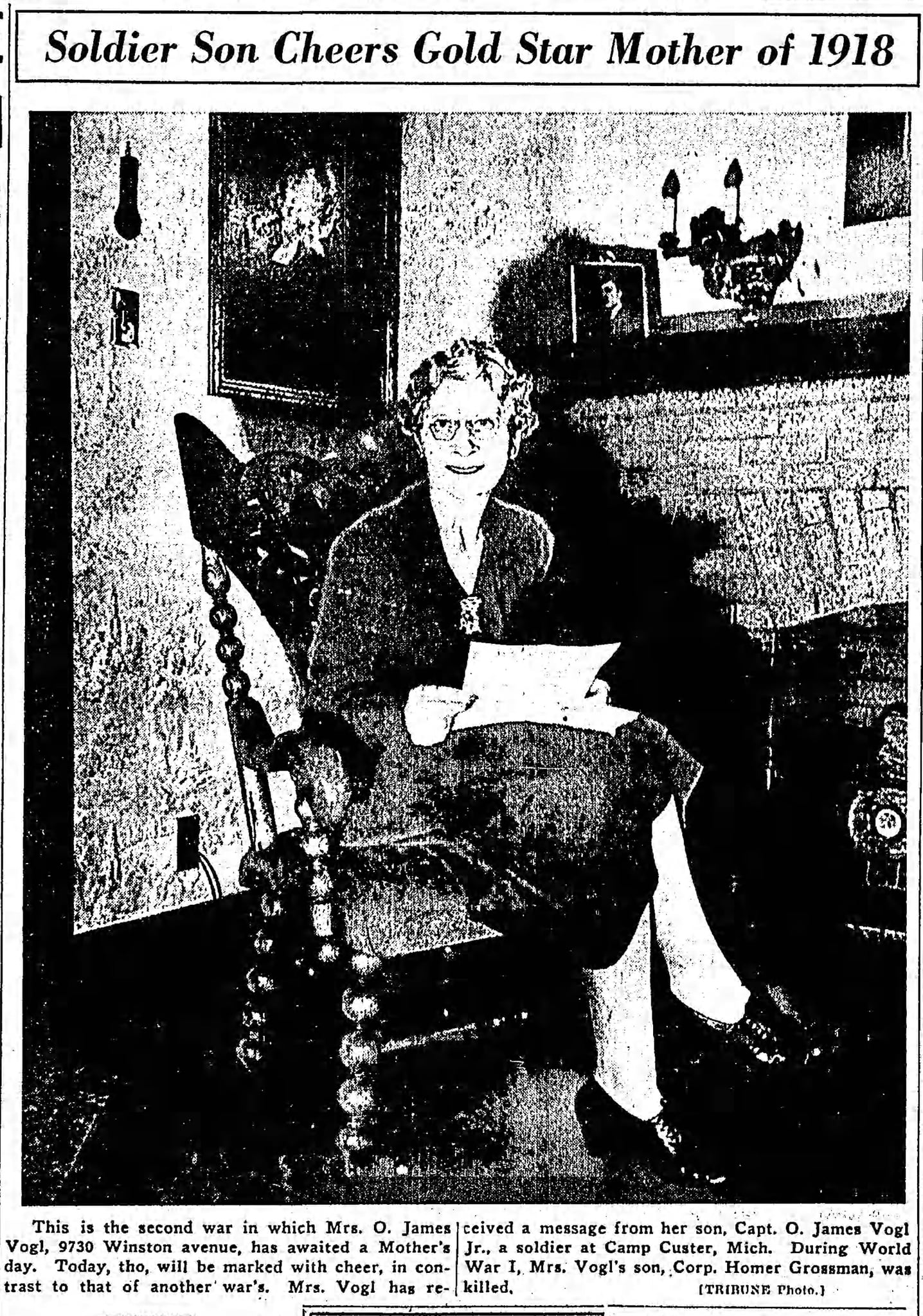
The Ridge has a long affiliation with the Gold Star Mothers movement. The Chicago Council was founded by a woman named Jeannette (Mrs. Oscar J.) Sachs Grossman Vogl, who served as the first president. Her son from her first marriage, Corp. Homer Grossman, 19, was killed and buried in France.
Mrs. Vogl and her family moved from Chicago for her husband’s business career around 1920 and returned in the late 1930s, settling in Beverly, first on 105th Street by Hale Avenue, then on 97th Street and Winston Ave. Their son, Oscar J. Vogl, Jr., graduated from Morgan Park Military Academy and served in and survived World War II. She was written about in the newspapers for having sons who served in both wars. Mrs. Vogl was active in local organizations, and eventually moved to California where her son lived. She died in 1960.
In 1920, the planting of “memorial trees” to honor the WWI dead began, and many were planted in the Forest Preserves of Cook County. Several monuments were also installed in the preserves.
Dan Ryan served as President of the Cook County Board in 1921-22. He had four sons who served in the war. During his tenure, it was proposed to place captured German tanks in the preserves, but Ryan opposed this, stating the preserves should remain “peaceful.” However, he allowed the Gold Star groups to continue to place markers.
Ryan stated in a letter that appeared in the Tribune:
“We have paid tribute to the glorious memory of our men who fell in battle by our actions in authorizing the erection by Gold Star mothers and fathers of bronze tablets and the planting of memorial trees in several of the tracts within the boundaries of the district.”
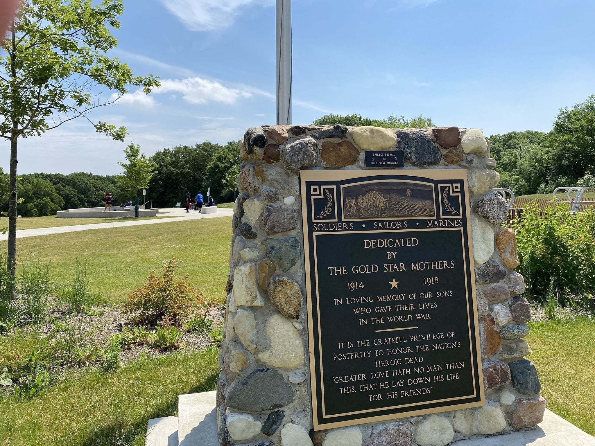
A monument was installed in the woods that would be renamed for Dan Ryan, at 87th Street and Western Ave. We have not been able to find the exact date that the monument was installed although it was there before August 1932 when it was the site of a picnic mentioned in the Chicago Tribune.
By the mid-2010s, the monument in Dan Ryan Woods had deteriorated into a public eyesore. Beverly resident Tim Noonan, now a member of the RHS Board, led the efforts to restore the monument. The Dan Ryan Woods monument was rededicated in 2018, with the participation of local Gold Star Mothers.
In recent weeks, thanks to introductions by Tim Noonan, four American Gold Star Mothers were interviewed for a feature story in the Daily Southtown newspaper of the Chicago Tribune.
https://www.chicagotribune.com/suburbs/daily-southtown/ct-sta-gold-star-mothers-st-0923-20210924-cdkzfvwbuzh5zlezr3go6g2zd4-story.html