
Explore the RHS Facebook Archives, a rich repository of local history written by Carol Flynn. For two decades, Carol brought a deeply dedicated voice to public education at RHS. Her role as Facebook administrator through mid-2025 naturally extended her prolific research into meticulously detailed articles, most notably her multi-part historical series posts. Today, Carol continues her local history writing for The Beverly Review and other outlets.
All Posts
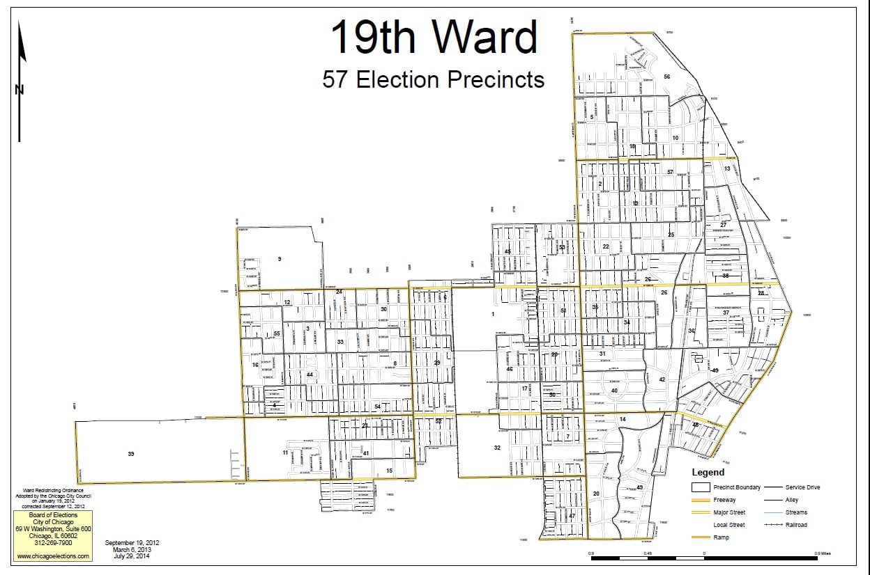
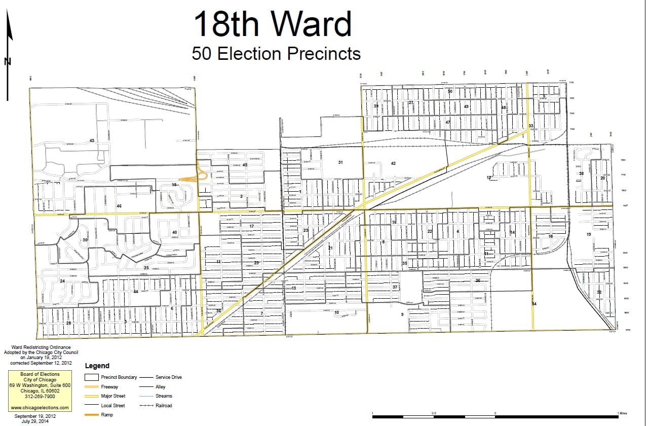
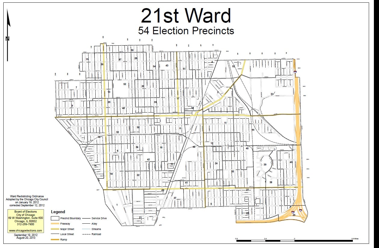
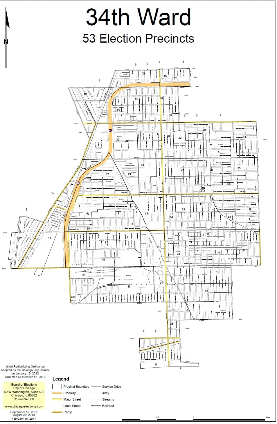
The History of The City Wards in The Ridge Communities – Part IThe Current Picture
As we wrap up one series, the Native Americans on the Ridge, we will also start a new one on the history of the city wards on the Ridge. This series will not be posted on other pages – readers who are interested in this topic are encouraged to follow the Ridge Historical Society page.
“Redistricting” is one of the hot topics in Chicago politics right now, so it’s the perfect time to look at the history of the city ward system in relationship to the neighborhoods that RHS covers. We will start with a review of the situation as it stands today.
The City of Chicago is divided into 50 legislative units called wards. The voters in each ward elect an alderman every four years to represent them on the Chicago City Council, the legislative branch of the city government. The presiding officer of the Chicago City Council is the Mayor, currently Lori E. Lightfoot, and the City Clerk of Chicago, currently Anna M. Valencia, is the secretary. The aldermen elect a President Pro Tempore from within their ranks to serve in the absence of the Mayor. This position is currently held by Brendan Reilly, the alderman of the 42nd ward.
The historical communities represented by the Ridge Historical Society, that is, Washington Heights, Beverly Hills, Morgan Park, and Mount Greenwood, currently fall into four wards – 18 (Derrick G. Curtis, alderman), 19 (Matthew O’Shea, alderman), 21 (Howard Bookins, Jr., alderman), and 34 (Carrie M. Austin, alderman). All of these aldermen are up for re-election in 2023.
Establishing wards and deciding their boundaries have always been intense political exercises in Chicago. The City redraws the ward map every ten years based on population changes reported in the U.S. Census. The goal is to have fifty wards of roughly the same number of residents. Ward boundaries are different from “neighborhood” boundaries, police districts, school districts, etc. All of these geographical – really, geopolitical – divisions are arrived at separately.
If 41 of the 50 aldermen approve a new ward map by an official vote of the City Council, then there is no public referendum on the issue. If no map gets this required support, then voters decide between competing proposals.
Next post: The Origins of The Ward System
National Gold Star Mother’s and Family’s Day
Sunday, September 26, the last Sunday in September, is National Gold Star Mother’s and Family’s Day. On this day, we recognize the women whose sons and daughters died during or because of active service in the U.S. military.
The Gold Star designation started during World War I. Families with members in the service displayed a service flag in their windows. A blue star meant that the person was in active service. The entire community mourned if the star was changed to gold, signifying that person had died. By the time the war ended in November 1918, over 110,000 Americans had lost their lives.
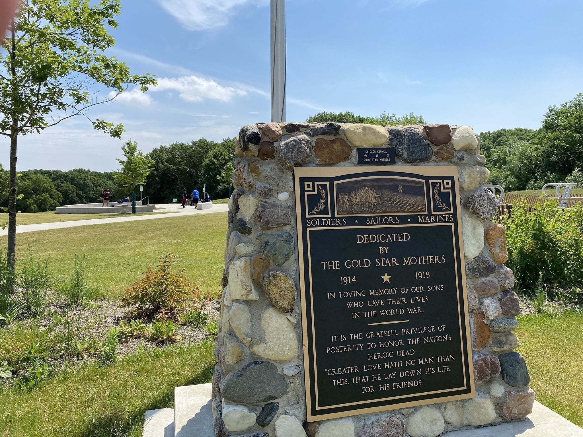
Gold Star Mothers joined together to raise funds to help other Gold Star Mothers, some of whom, dependent upon their sons for their living, were left destitute with their loss. Gold Star Mothers also helped servicemen returning from Europe. The Chicago Council of Gold Star Mothers started in 1918. The grassroots movement led to the formation of the American Gold Star Mothers, a national membership organization, in 1928.
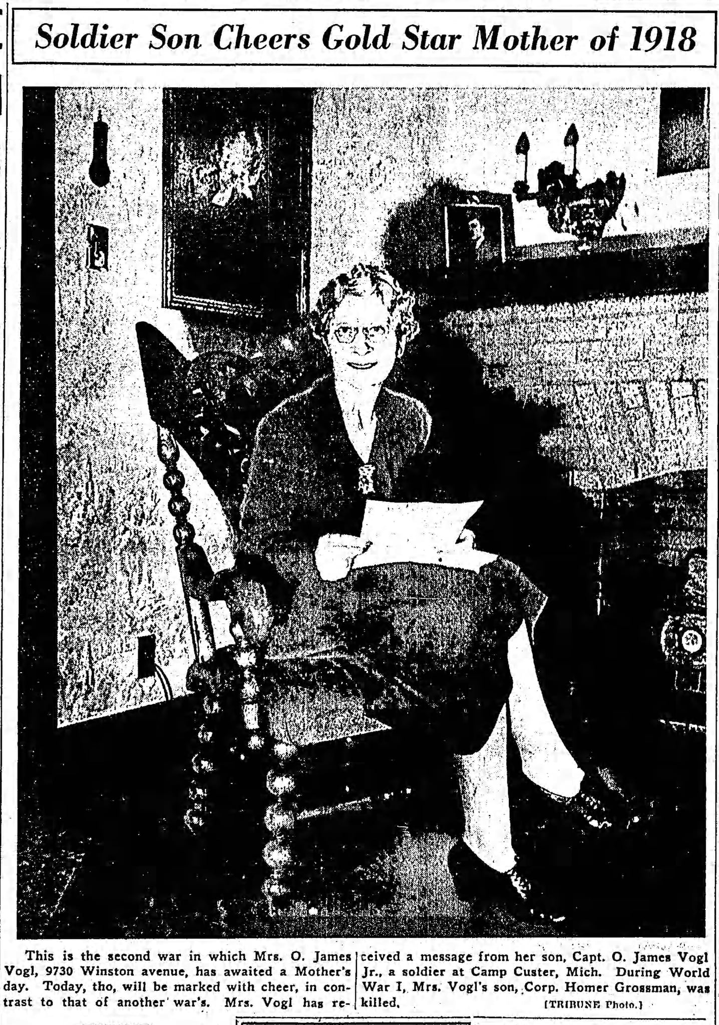
The Ridge has a long affiliation with the Gold Star Mothers movement. The Chicago Council was founded by a woman named Jeannette (Mrs. Oscar J.) Sachs Grossman Vogl, who served as the first president. Her son from her first marriage, Corp. Homer Grossman, 19, was killed and buried in France.
Mrs. Vogl and her family moved from Chicago for her husband’s business career around 1920 and returned in the late 1930s, settling in Beverly, first on 105th Street by Hale Avenue, then on 97th Street and Winston Ave. Their son, Oscar J. Vogl, Jr., graduated from Morgan Park Military Academy and served in and survived World War II. She was written about in the newspapers for having sons who served in both wars. Mrs. Vogl was active in local organizations, and eventually moved to California where her son lived. She died in 1960.
In 1920, the planting of “memorial trees” to honor the WWI dead began, and many were planted in the Forest Preserves of Cook County. Several monuments were also installed in the preserves.
Dan Ryan served as President of the Cook County Board in 1921-22. He had four sons who served in the war. During his tenure, it was proposed to place captured German tanks in the preserves, but Ryan opposed this, stating the preserves should remain “peaceful.” However, he allowed the Gold Star groups to continue to place markers.
Ryan stated in a letter that appeared in the Tribune:
“We have paid tribute to the glorious memory of our men who fell in battle by our actions in authorizing the erection by Gold Star mothers and fathers of bronze tablets and the planting of memorial trees in several of the tracts within the boundaries of the district.”
A monument was installed in the woods that would be renamed for Dan Ryan, at 87th Street and Western Ave. We have not been able to find the exact date that the monument was installed although it was there before August 1932 when it was the site of a picnic mentioned in the Chicago Tribune.
By the mid-2010s, the monument in Dan Ryan Woods had deteriorated into a public eyesore. Beverly resident Tim Noonan, now a member of the RHS Board, led the efforts to restore the monument. The Dan Ryan Woods monument was rededicated in 2018, with the participation of local Gold Star Mothers.
In recent weeks, thanks to introductions by Tim Noonan, four American Gold Star Mothers were interviewed for a feature story in the Daily Southtown newspaper of the Chicago Tribune.
https://www.chicagotribune.com/suburbs/daily-southtown/ct-sta-gold-star-mothers-st-0923-20210924-cdkzfvwbuzh5zlezr3go6g2zd4-story.html
Native Americans and the Blue Island Ridge – Part 18Conclusion – Land Acknowledgement Statement
A suggested Land Acknowledgement Statement for an organization, business, or individual on the Ridge (like the Ridge Historical Society) would be:
“We acknowledge that we are located on the ancestral homelands of the Potawatomi tribe, a member of the Council of Three Fires with the Ojibwe and Odawa Peoples. Other tribes that lived in the Blue Island area include the Miami and the Illinois Confederation. Many additional tribes including the Fox, Sauk, Winnebago, Menominee, Meskwaki, and Kickapoo lived nearby and accessed the area for trading and portage routes.”
The rationale for this statement is that the Potawatomi were the dominant Native Americans living around the Blue Island area in 1833 at the time of the signing of the Treaty of Chicago. The Council of Three Fires, a confederation of the Ojibwe, Odawa, and Potawatomi tribes, ceded the land to the U.S. Government at that time. The Miami tribe also had a presence here, concurrent with the Potawatomi, and before that, until the late 1700s, tribes from the Illinois Confederation lived in the area until driven out by the Miami and Potawatomi.
Many other tribes lived nearby. This land is located on the Vincennes Trace and Calumet waterways, and the land and water routes were used for trading and transportation/migration. These tribes included the Fox, Sauk, Winnebago, Menominee, Meskwaki, and Kickapoo.
Just this month, a research article in the journal Science reported that fossilized footprints found at White Sands National Park, New Mexico, date back 21,000 to 23,000 years. This puts humans in North America thousands of years earlier than thought.
However, Native Americans are not relics of the past. The 2020 U.S. Census reported 9.7 million American Indians and Alaska Natives in the U.S. population.
Understanding the history of Native Americans is critical, and sharing information like this series to educate the community is the role of an organization like RHS. Other organizations, businesses, schools, churches, and individuals share the responsibility to evaluate their commitment to the present and future issues of this group of American citizens.
Image:
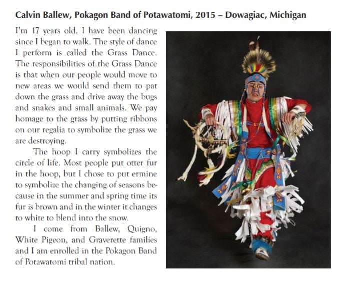
Sharon Hoogstraten, a professional photographer who now lives in Chicago, is a tribal member of the Citizen Potawatomi Nation. Through her exhibit “Dancing for My Tribe” she documented and preserved Potawatomi culture.
The exhibit, made up of individual portraits of contemporary Potawatomi in their regalia, conveys the story of a modern people preserving the traditional dress of their ancestors. Regalia is traditional tribal dress that identifies a person and tells his or her individual story, not a costume for pretense. No two examples of regalia are alike.
The exhibit premiered in 2014 at Rockefeller Memorial Chapel at the University of Chicago.
This is one entry from the exhibit, from the Artist’s Statement. The Pokagon Band of Potawatomi in Michigan is the group living closest to Chicago.
History of the Chicago Wards – Post 2The Beginning
In 1830, Chicago was not yet a city, and Cook County did not exist. For voting in State of Illinois elections, the Chicago area was considered a precinct of Peoria County. Cook County was formed in 1831, and the unincorporated Fort Dearborn settlement at the juncture of the Chicago River and Lake Michigan became the county seat. The area continued to grow, and Chicago incorporated as a city in 1837 and became the county seat.
There are a variety of models for U.S. city governments. Chicago uses a variation of a system brought over from England where wards were administrative units centered around castles. Many American municipalities used the early model of a city council made up of aldermen elected by local citizens to represent geographic units of the city called wards. The council is led by a full-time, paid mayor elected separately, that is, not chosen from or by the aldermen.
Other cities now use other models such as paid city managers or small governing boards with commissioners. The ward system is considered democratic, but can also be cumbersome and result in gridlock. Other systems are considered more efficient, but some are less representative of the will of the people.
The Act of Incorporation for the City of Chicago, 1837, established the city’s form of government, which is the only form the city has ever known. The charter specified as officers an elected mayor heading a “common council” made up of the aldermen from the city wards. Other city officers included a Clerk, a Treasurer, Collectors (for taxes and assessments), and others to be established.
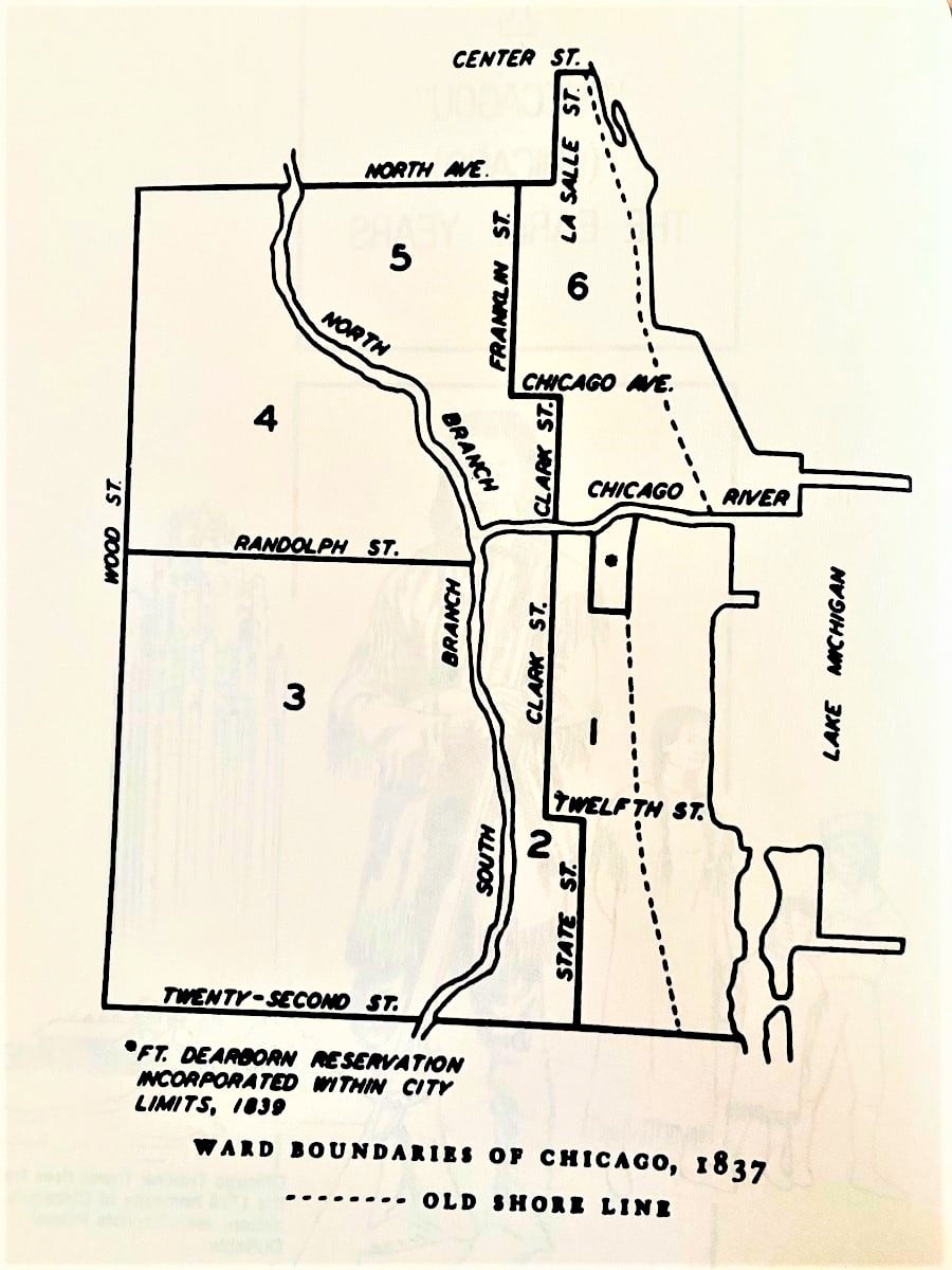
Initially, there were six wards. Two aldermen and one assessor from each ward were elected. Annual elections on the first Tuesday in March for all the offices were mandated.
The “common council” was empowered to handle all aspects of city management, ranging from the control of city finances and property to “preventing the rolling of hoops, playing at ball or flying of kites or any other amusement … having a tendency to annoy persons … or to frighten horses.”
The first six wards were clustered around the site of Fort Dearborn. However, the city didn’t stay small for long. As the city expanded due to population growth and annexation of neighboring communities, the number of wards increased. Also, by 1860, the city had begun to further divide the wards into election precincts. Major acquisition and annexation of land to Chicago occurred during the 1800s, and by 1890, when the Blue Island Ridge territories began to annex, the city was up to 34 wards and 68 aldermen.
Wards were theoretically established based on population size, and determining the boundaries of wards was always a political ordeal.
For example, in 1859, a group proposed that the number of wards be increased from ten to twenty-one because, it was alleged, the wards were too large both population- and geography-wise for efficient voting, resulting in some people having to travel miles to a voting place, and others being denied the opportunity to vote because the lines were so long. The Chicago Tribune called this “brazen lies” and reported the redistribution carved the city into “parallelograms, rhomboids, polygons, diamonds, triangles, and trapezoids, wholly regardless of population, property or propriety.” The paper stated that the “Graveyard on the North Side” (now Lincoln Park) was laid out as a ward in the new system. The proposal went nowhere.
Next post: Washington Heights, including Beverly, is annexed to the City of Chicago and joins the ward system.
October is Squirrel Awareness Month. Love 'em or hate 'em, they are part of the fabric of the community. I'm looking for anyone who has spotted, and preferably managed to photograph or videotape, the white squirrel(s) that live in Beverly Park (103rd Street, Chicago) for an article I am working on. Any pictures or stories to share about these little guys?
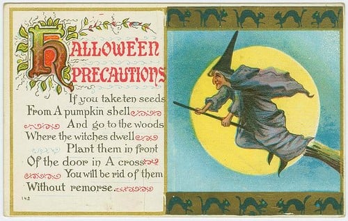
Happy Halloween from the Ridge Historical Society. Here is a vintage postcard with some sage old folklore advice. Of course, it depends if it is a good witch or a bad witch ….
Ridge Historical Society
Halloween – October 31, 3021: The “Tombstone House”
By Carol Flynn
It’s Halloween, so it is a good day to look at the macabre in the neighborhood. This isn’t a ghost story – in fact, it’s pretty much the opposite, a “debunking” story. But it also illustrates that true history can be as interesting – and strange – as legends.
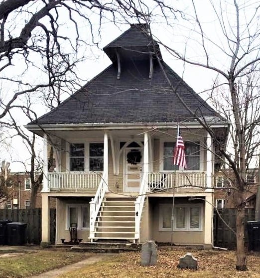
The Ridge Historical Society (RHS) is regularly asked about the tombstones that are on the front lawn of a house in the 1700 block of West 96th Street. Are they real? Yes. Are people buried there? Not very likely. Was that a cemetery? No. How did the tombstones get there? That’s a good question and the answer remains elusive.
Here is the information RHS has gathered to date. Let’s start with the house. The house was actually originally a church.
St. Paul’s Bible Church at 94th and Winchester started as a Sunday school in the Longwood train station at 95th Street, then the congregation used a tent. One of the founders of the church was William Merchant Richardson French, the first executive director of the Art Institute of Chicago, whose historic house still stands in north Beverly.
In 1893, the congregation built a small wooden church. This wooden church was replaced by a stone church in 1902-3. The wooden church was moved and became a private home on 96th Street.
Moving houses was not uncommon in the past. They were placed on rollers and dragged to the new location by horses. It could take days to move a house but it was easier than building a new one.
Now, the tombstones. The names on them are Johan Sandtner, d. 1914; and Barbara Sandtner, b. 1859 d. 1915. RHS researchers located death and burial records for these people. These markers belonged to a couple that is buried in St. Mary’s Cemetery at 87th Street and Pulaski Road. Their names are recorded as John and Barbara Santner. John died at 4313 Lake Park on March 9, 1914, and Barbara died at 5836 Princeton on May 11, 1915.
It was not unusual to have multiple spellings of names in the past. Sometimes people changed their names to be more Anglicized. One conjecture is that the tombstones were replaced to correct or change the names from Sandtner to Santner, and from Johan to John. Then the old gravestones were discarded.
What is still the question is exactly how the tombstones wound up in front of the relocated church-turned-house on 96th Street. They’ve been there for decades. In the 1980s, the owner or resident of the house told the RHS Historian that he placed the markers there, but he would not say where he got them originally.
A few years ago, another person reported to RHS that he was told by the man there that the tombstones were found in the basement of the house when he moved in, and he put them out in front. The man at the house said that perhaps there had been a graveyard there with the church.
That seems very unlikely because there is no documentation that that building was ever a church at that address, only a private residence. If St. Paul’s had a graveyard, it would have been at the church site a few blocks to the north.
So are people buried on 96th Street? Well, the Santners are not, and there is no record of any kind of cemetery ever being there. THAT much can be confirmed.
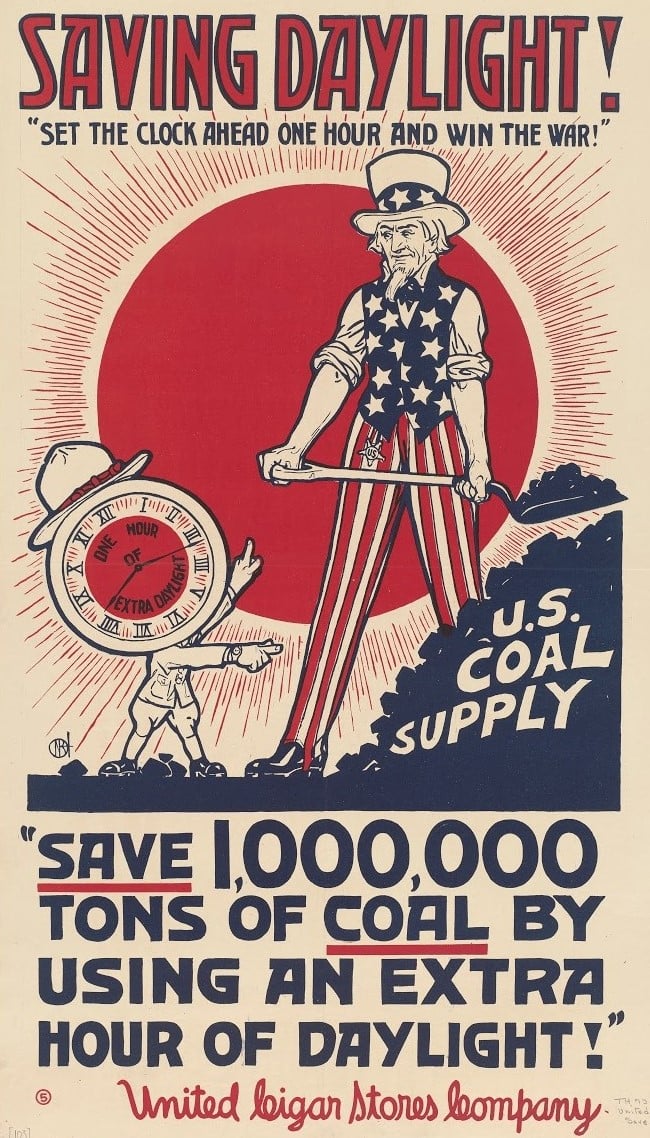
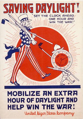
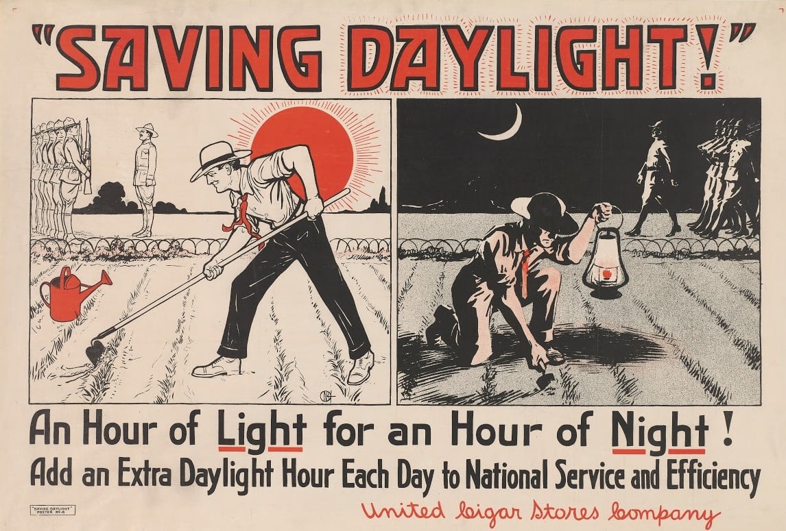
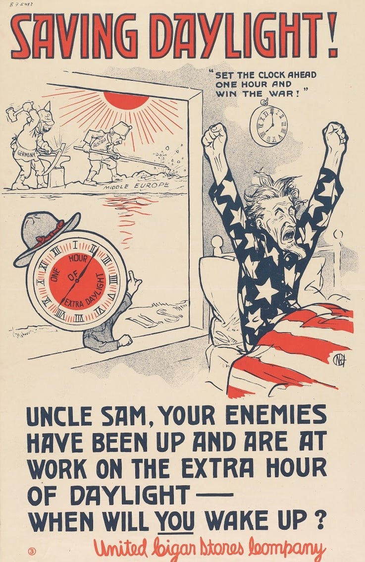
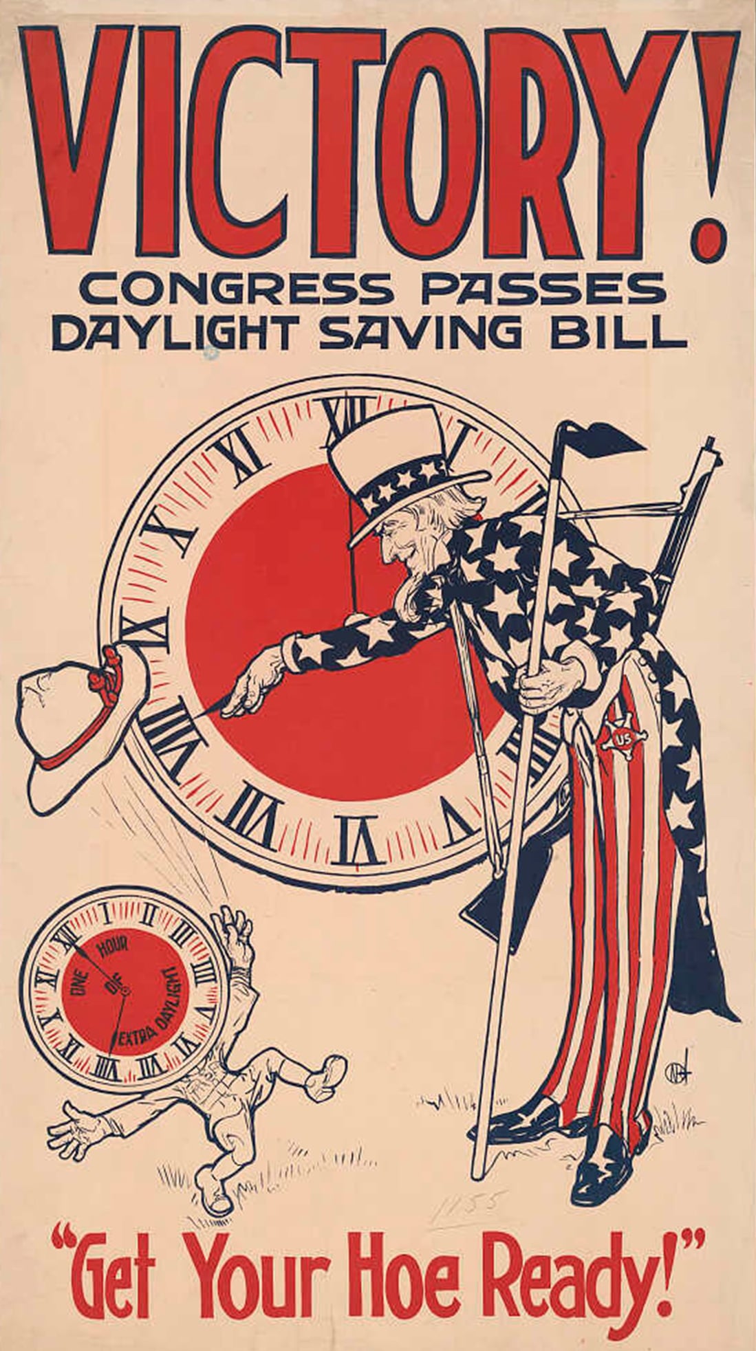
Daylight Savings Time
Daylight savings time (DST) ends tonight – technically, at 2:00 a.m. on Sunday, November 7, 2021. Clocks should be turned back to 1:00 a.m. to gain an hour (“Spring forward, Fall back”).
DST is not part of nature’s plan – it is a manmade contrivance, and the artificiality starts in the Spring when an extra hour of daylight is added. Winter time is actually “standard time.”
The idea of adjusting time to coincide with the changing amount of available sunlight due to the rotation of the Earth goes back to ancient times. The Romans used water clocks that had different scales for different months. Daylight was always divided into 12 hours, but the hours varied in length from 75 minutes in the summer to 44 minutes in the winter.
Benjamin Franklin wrote a satirical letter to a Parisian newspaper in 1784 when he was Ambassador to France that indirectly touched on DST. He reported how surprised he was to discover the sun shining at 6:00 a.m. one day when he was accidentally awakened. He, like most people, did not rise until noon and go to bed until 3 or 4:00 a.m. He commented on how much candle wax and lamp oil could be saved if people adjusted their schedules to the sun’s schedule.
Instead, people adjusted the sun’s schedule to their own.
Although there was some experimentation with DST in other countries, it was the German Empire and Austria-Hungary that began the first national DST system in 1916 during World War I to conserve coal. Britain and its allies soon followed. The United States began DST in 1918.
In the years after the war, DST was discontinued in many countries, then restarted again. It was popular again during World War II, and came strongly into use in the 1970s with the renewed emphasis on conserving energy.
In the U.S., DST has been in use since 1918, with changes during the years to arrive at the schedule we use now. There is no uniform system throughout the world; there are even variations within the U.S.
Although the initial emphasis was on saving fuel, there are other outcomes of DST. The “plus column” includes increased economic activity like shopping during the extra daylight time, more outdoor recreation and leisure activities, and even some reduction in crime. Retail stores and the golfing and gardening industries are examples of pro-DST supporters.
The “minus column” includes the disruption in human circadian rhythms affecting sleep and other patterns, an increase in car accidents with the return to standard time, and a loss for indoor entertainment activities. More gas is used for cars during the additional daylight. Movie theaters and the T.V. and cable industry, and indoor dining and recreation places prefer standard time. Farmers don’t care for DST because cows don’t watch the clock to adjust their milking patterns. And of course, there is always confusion when the clocks are changed.
Public health officials recommend the best option would be to return to year-round standard time. However, many supporters want to change to permanent daylight savings time.
It takes an act of Congress to make any changes to the schedule. States cannot implement permanent DST. They can opt out of DST, but they cannot opt out of standard time.
History of the Chicago Wards – Post 3Annexation of Washington Heights to Chicago
The villages and towns around the City of Chicago, the “suburbs,” generally annexed to improve services, especially water and sewers. In addition, police and fire departments, schools, libraries, and other public services were expensive for small communities to maintain on their own.
The suburbs began to see real growth in the 1870s. The Great Chicago Fire of 1871 displaced a lot of city residents and broke up old neighborhood associations. Businesses encroached on the remaining residential neighborhoods to reestablish themselves. Moving outside of the city offered homeowners the advantages of cheaper homes and less congestion. For those who lost everything in the fire, it was a chance to start over, away from the conditions and constant reminders of the trauma they had experienced.
According to the Chicago Tribune in 1873, one of the hottest suburban areas for speculation and growth was Washington Heights and Morgan Park on the Blue Island Ridge. Land prices in the area had doubled in the past year.
Even before the Fire, the Washington Heights area was being lauded in the Tribune. In 1869, the paper wrote that “among the many suburban places …, there is none more attractive than the new one … called Washington Heights.” The article mentioned the “high and beautiful wooded land, which commands a fine view of the city and Lake Michigan.” It also mentioned the work that was in progress by the Blue Island Land and Building Company, the construction of “beautiful, wide avenues” and the laying out of five- and ten-acre lots, that would be marketed in the coming year as Morgan Park.
In 1870, the “dummy line” bringing the Rock Island Railroad west to Washington Heights was established. This played a major role in increasing accessibility to the area, allowing for the rapid growth that began in the 1870s. Not just homes for the wealthy and middle-class were being built; laborers bought up small lots along the railroad lines and built cottages.
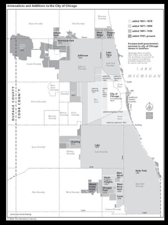
The largest annexation to the City of Chicago occurred in 1889 when 125 square miles of territory was added to the city. This included all of Hyde Park Township and Lake Township on the south side, and Jefferson Township and Lake View Township on the north side. New wards were formed, bringing the total for the city to thirty-four wards.
This annexation almost brought the city to the boundaries of the Village of Washington Heights, which included today’s Beverly area, and Morgan Park.
The residents of Washington Heights were mostly in favor of annexation to the city. The major issue for the village was dealing with sewage, and the sewer system of the city, which then ended at Halsted Street, could be extended west.
Prominent people such as Robert Givins, real estate developer and builder of the Castle at 103rd Street and Longwood Drive, and William Barnard, owner of the largest tract of land in the community, petitioned in favor of annexation. There were reports of some initial resistance, although minor, from some of the older farmers in the area.
There was one snag in annexing Washington Heights, however. A three-square-mile stretch of land from 87th Street to 95th Street west of State Street, which included today’s North Beverly and Dan Ryan Woods, was not incorporated as part of any municipality, including the City of Chicago or the Village of Washington Heights. This land lay between the city and the village, and due to the way the annexation laws were written, prevented annexation because the land would not be continuous. The City of Chicago took legislative action under an old law to annex this parcel to the city in April of 1890, opening the way for a vote to annex the Village of Washington Heights.
In November of 1890, the voters of both the city and the village approved the annexation of Washington Heights to Chicago.
The annexation of the small town of Fernwood to the east of Washington Heights was also on the ballot, and although the city voters approved it, the Fernwood voters did not. However, the following year, Fernwood voters did approve annexation.
It was assumed by just about everyone that the annexation of Washington Heights meant that Morgan Park would follow within a year or two. However, annexation to the city became a real political issue for Morgan Park, and the decision to annex was not agreed upon for another twenty-four years.
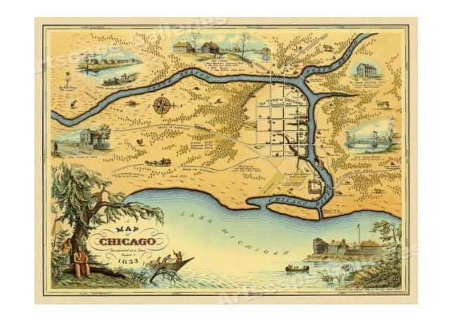
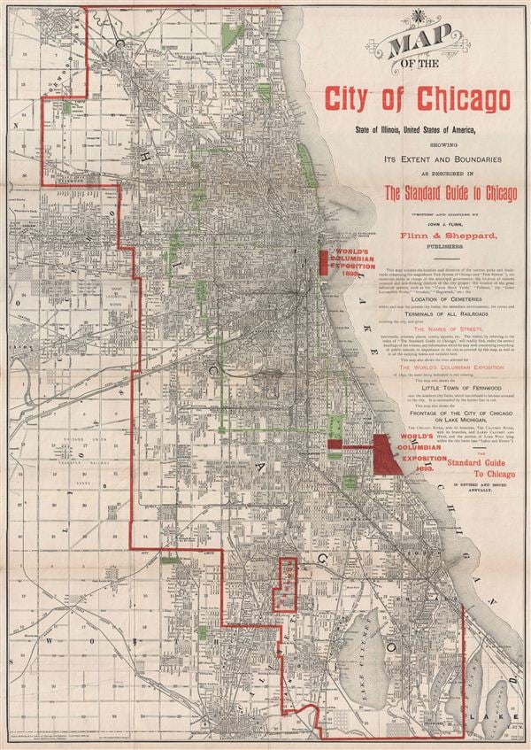
This 1890 map of Chicago includes the new territory of Washington Heights. A bigger version of it can be accessed through Google.
Next post: Assigning Washington Heights to the Ward System
Happy Thanksgiving
Hoping to help reunite a country torn by war, Thanksgiving became a fixed holiday under President Abraham Lincoln in 1863.
There is a lot of information out there about early harvest and thanksgiving celebrations on American soil by the European colonists, but generally, when we think about the event that influenced today’s celebration, we’re looking at the celebration that occurred in 1621 in Plymouth, Massachusetts, as a harvest feast. The celebrants were the English Protestants called Puritans, known in American history as the “Pilgrims,” who had split from the Church of England and come to the New World on the ship called the Mayflower; other Englishmen such as the crew who also came on the ship; and the Wampanoag people, the Native American tribe that had lived in the area for over 12,000 years.
Note that there was already a colony of settlers in Jamestown, Virginia, dating to 1607. Most likely they also held harvest feasts, but the Plymouth celebration is the one for which detailed records exist.
The Pilgrims intended to go farther south than Massachusetts. Delays caused them to not leave England until September, and they arrived in America in November. Bad weather forced them to land where they did and remain there for the winter. They were not at all prepared for the freezing cold and snow they encountered in the New World, which had a much harsher climate than that of England. The one hundred settlers and fifty crew members stayed on the ship in Plymouth harbor that first winter. Many of them, weakened by the trip and suffering from scurvy from lack of Vitamin C, and some already suffering from tuberculosis, came down with pneumonia. About half of them died on the ship, most without ever setting foot in their new country.
They were finally able to come ashore and build huts in March 1621. They were greeted by the Wampanoag people. Early relations between the Native Americans and the European settlers were cordial. The Wampanoag showed the Pilgrims how to fish and hunt in the area, and how to cultivate the native food plants and gather fruit. Without the generosity and hospitality of the Native Americans, the settlers had a much poorer chance of surviving.
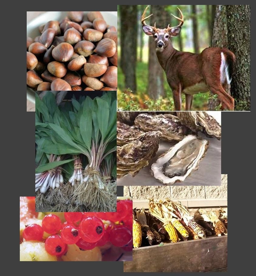
As far as what was available for a harvest feast that fall, many items we take for granted now were not available then. There were no sweet or white potatoes. It would be another hundred years before potatoes came up to North America from South America. The Pilgrims had not yet planted wheat fields so there were no pies and no bread. The sugar rations they brought with them had quickly been depleted on the journey over, so there were no jellies or sweet desserts. They brought no large livestock with them on the Mayflower, only chickens, and a few pigs and goats, so there were no dairy products except maybe goats’ milk. No ovens had been constructed yet for baking, so all cooking was done over open fires.
A journal kept by Puritan William Bradford reported the colonists went fowl hunting for this harvest feast. Duck, geese, swans, and turkeys were all plentiful. The Wampanoag guests brought a gift of five deer to the celebration, so venison, probably some roasted and some served in a hearty stew, was without doubt on the menu. Historians also believe that seafood was a major component of the feast, this being New England by the coast. Mussels, lobster, bass, clams, and oysters were readily available. The first Thanksgiving was very heavy on animal protein.
The vegetables the Wampanoag cultivated at the time included corn, pumpkins, squash, turnips, garlic, onions, beans, carrots, lettuce, spinach, and cabbage. The pumpkins were roasted. Fruits available for gathering included blueberries, plums, grapes, and gooseberries. Cranberries were there but it was another fifty years before there were reports of boiling them with sugar to make a jelly.
Flint corn, the multi-colored “Indian corn,” was plentiful at the first harvest. Most likely, the corn was ground into cornmeal, which was boiled and pounded into a thick corn mush or porridge. This was called Indian pudding, a take on the English fondness for “hasty pudding.” Later this dish was sweetened with molasses, made from sugar cane brought up from the Caribbean islands.
Herbs, and nuts like chestnuts, walnuts, and beechnuts, were plentiful from the forests. Along with onion, these would have been used for stuffing the fowl and flavoring dishes.
The celebration itself was a three-day event, with feasting, ball games, singing, and dancing. “Grace” was likely said before meals, but it was several years later that an official prayer service was added to the annual harvest celebration to give thanks for rain after a two-month drought.
Within a few years, the Pilgrims planted wheat and other crops. Other settlers came, bringing dairy cows and honeybees. But it is the native foods that make the day what it is – pumpkins, white and sweet potatoes, corn, cranberries. At least 60% of the food crops grown throughout the world today originated with the Indigenous People of the Americas. And of course, turkeys are native only to the Americas.