
Explore the RHS Facebook Archives, a rich repository of local history written by Carol Flynn. For two decades, Carol brought a deeply dedicated voice to public education at RHS. Her role as Facebook administrator through mid-2025 naturally extended her prolific research into meticulously detailed articles, most notably her multi-part historical series posts. Today, Carol continues her local history writing for The Beverly Review and other outlets.
2021
Native Americans and the Blue Island Ridge – Part 5The Battle of Fort Dearborn
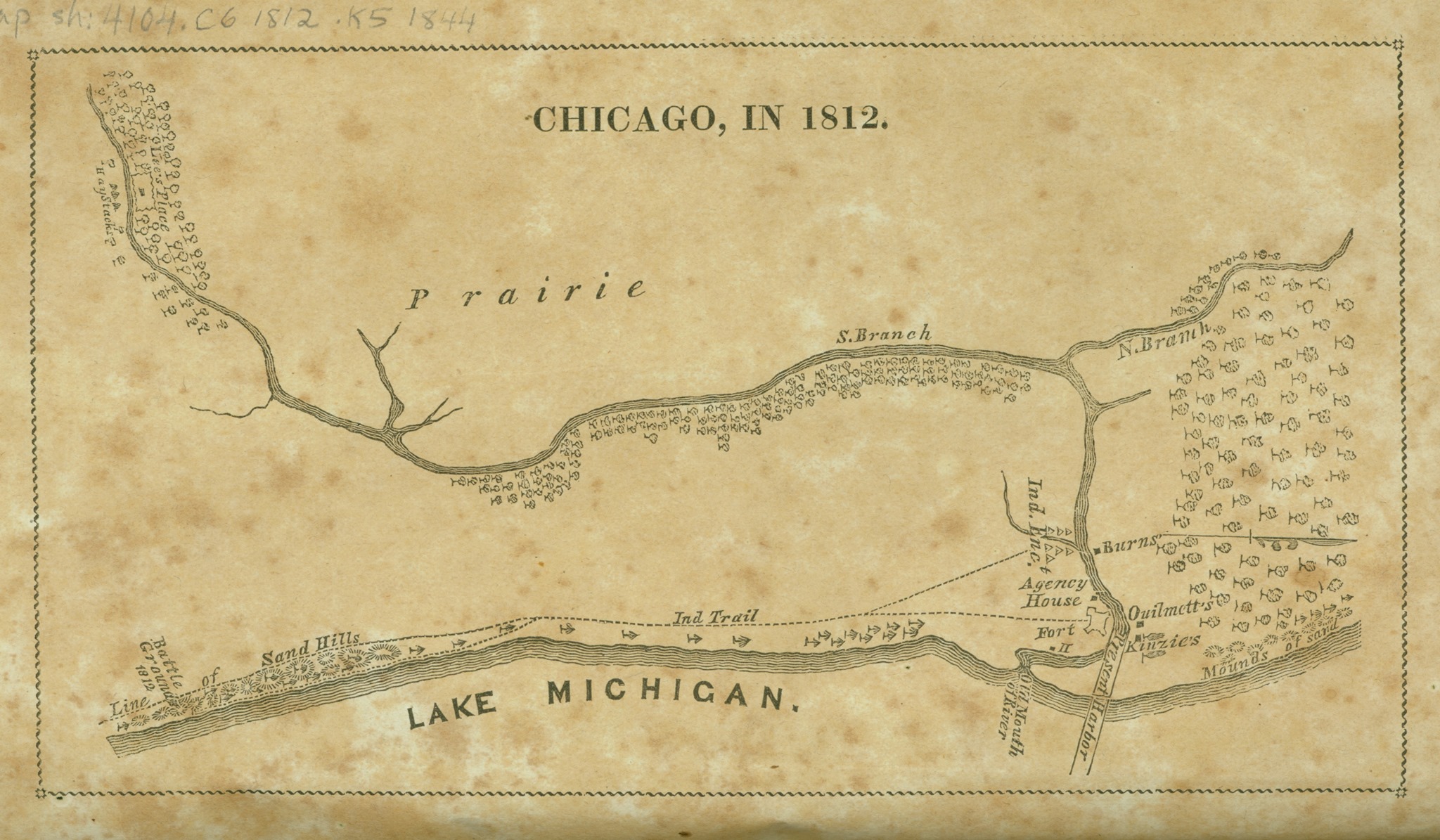
Fort Dearborn was built at the junction of the Chicago River and Lake Michigan in 1803 on land that Native Americans turned over to the new U.S. government by treaty after defeat in the Northwest Territory Indian Wars. The British, who had been allies of the Native Americans, also gave up their military presence in the Northwest Territory at that time.
However, even though the newly formed United States had won that war and claimed the Northwest Territory for its expanding borders, tensions between all the parties remained high.
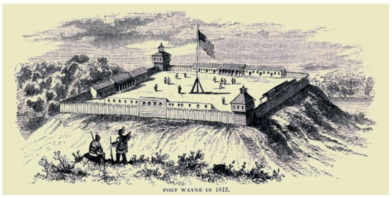
The “Chicago” area had over 40 Potawatomi villages in the early 1800s. Many Indian trails intersected just south of the Blue Island Ridge. It was a hub for the fur trade. As far as white settlement was concerned, it was remote wilderness at the time. Other U.S. forts were hundreds of miles away, such as Fort Wayne, located 200 miles to the east, where Fort Wayne, Indiana, is today.
U.S. settlers continued to expand into land designated by treaties for Native Americans, destroying the Indians’ ancestral lands and sacred sites in order to establish farmland and settlements. The U.S. government did not abide by the treaties it signed with the Native Americans. Great Britain saw the growing friction between the new U.S. government/settlers and the Indigenous People as an opportunity to further buffer their Canadian colonies from possible U.S. infringement, and possibly to try to win back some of the Great Lakes territories.
In 1811, British emissaries began enlisting Native Americans in the Fort Dearborn area against the U.S. settlers. The British told the Native Americans they would help protect their land from further encroachment. A U.S. citizen and a French-Canadian man were killed by a band of Winnebago Indians in what is now the Bridgeport section of Chicago. This inflamed tensions between the settlers and the Indians in the area, causing some settlers to move into Fort Dearborn and an armed militia from the fort to be formed.
In 1812, the U.S. declared war on the British empire and the War of 1812 began. In addition to conflicts over the land in North America, there were also continuing economic and trade disputes involving the U.S., Britain, and France. The British Royal Navy was seizing U.S. ships on the open sea and forcing people who claimed to be citizens of the new U.S. into service for Britain (called “impressment”).
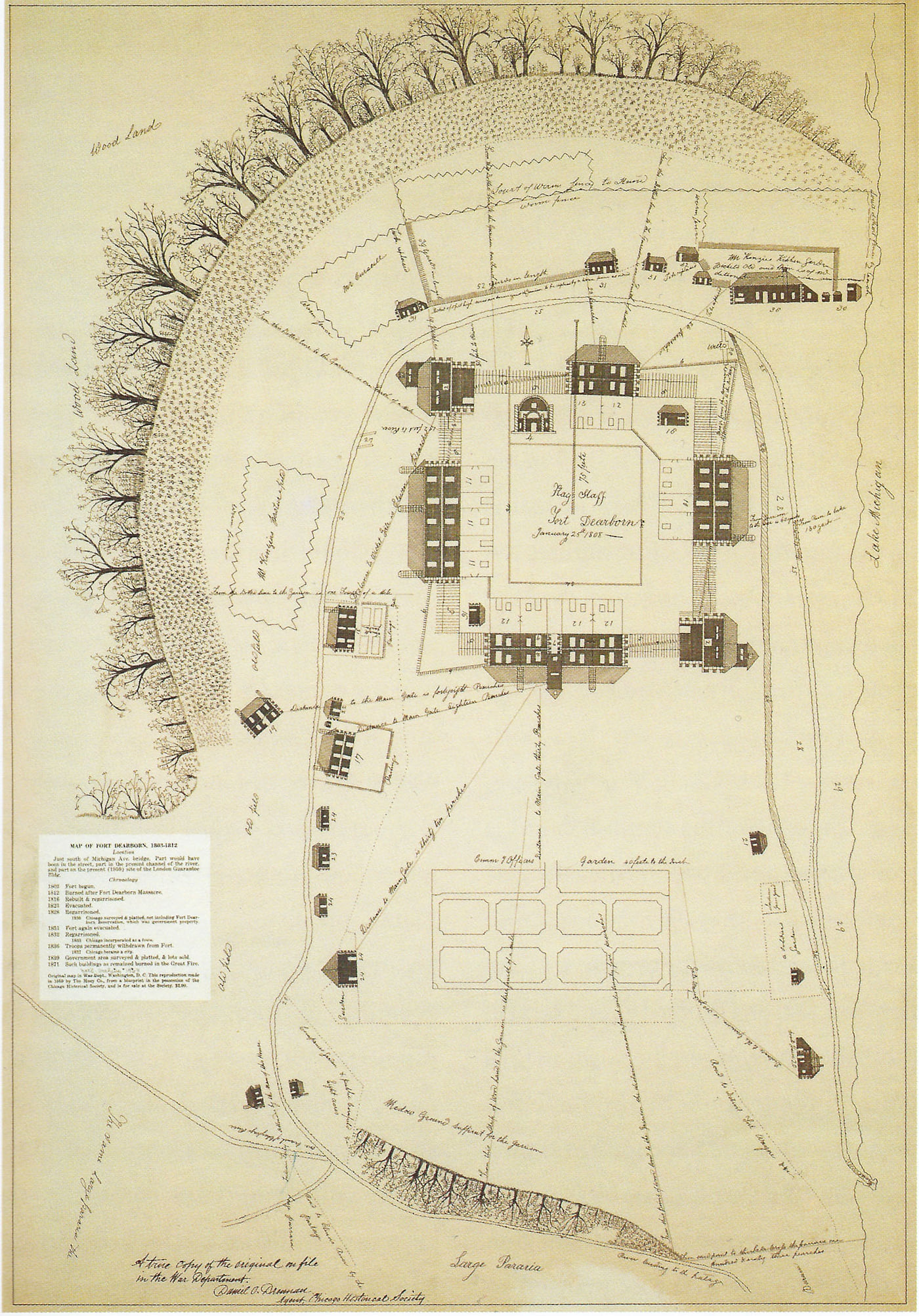
The British, moving south from their Canadian colonies, captured Fort Mackinac in Michigan. Worried that Fort Dearborn in “Chicago” could not be sustained, evacuation of the fort was ordered. Captain Nathan Heald, in command of Fort Dearborn, was ordered to destroy arms and ammunition and give remaining goods to friendly Indians to attain an escort to Fort Wayne. A group of 30 Miami tribesmen came from Fort Wayne to Fort Dearborn with a U.S. agent to provide an escort.
Heald met with local Potawatomi leaders to let them know he was evacuating the fort. The Indians understood Heald to say he would distribute the firearms, ammunition, provisions, and whiskey among them, and that, if they would send a band of Potawatomi to escort them safely to Fort Wayne, he would pay them a large sum of money. However, Heald destroyed the firearms, ammunition, and liquor.
Potawatomi Chief Black Partridge warned Heald that the young men of the tribe planned to attack the evacuating party and he could not restrain them. Despite the warning, Heald went ahead with the evacuation as ordered.
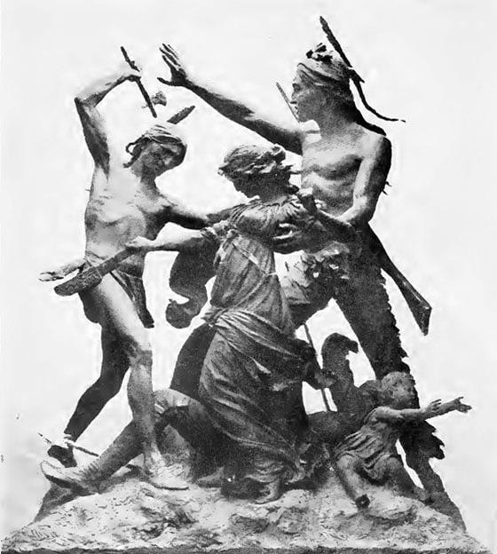
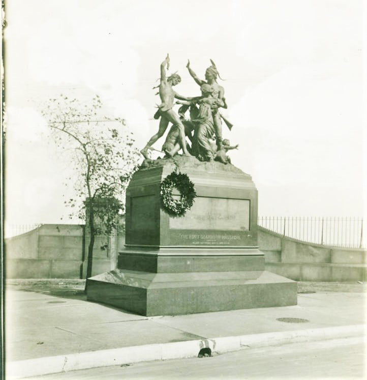
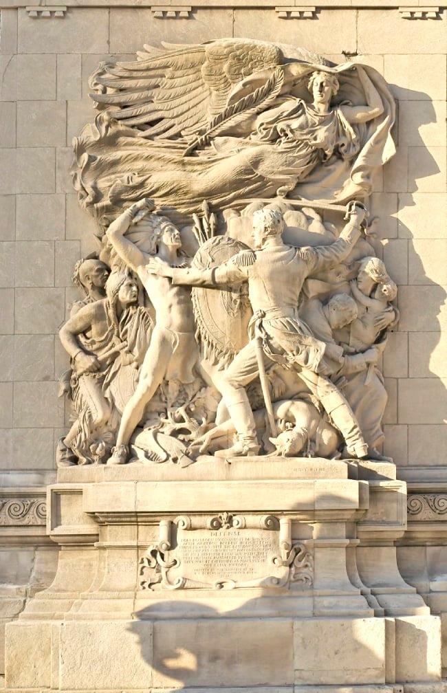
On August 15, 1812, the garrison left Fort Dearborn for Fort Wayne. There were 66 military men, nine women, 18 children, and the Miami escorts. They were attacked by 400 to 500 Potawatomi. Thirty-eight of the military, two women and twelve children were killed, and the rest were taken as prisoners. Fifteen Potawatomi were killed. Fort Dearborn was burned down.
Potawatomi Chief Black Partridge (sometimes translated as Black Pheasant) and his brother Waubonsie were not successful in stopping the attacks, but they and other Native American leaders in the area did what they could to aid the evacuees from Fort Dearborn. Black Partridge advocated for peaceful relations with the U.S. He was credited with saving the life of Mrs. Margaret Helm during the attack, and helping to free her husband, Lt. Lenai Helm. [However, when he returned to his village, he discovered that it had been burned by U.S. troops and among the massacre victims were his daughter and grandchild. He then joined in opposition to the U.S. A later battle included a young warrior named Black Hawk, a member of the Sauk, who will be discussed in a later post.]
The prisoners were sold to the British, who ransomed them back to the U.S. or set them free. Heald and his wife, both injured, escaped to Fort Detroit, controlled by the British, where they surrendered and were ransomed back to the U.S.
There were many discrepancies in the reports and stories of the battle. Even the exact location is disputed – Heald reported that it occurred at what is now Michigan Avenue and Roosevelt Road, but 18th Street and Prairie Avenue has become traditionally associated with the battle based on stories by the Kinzie family.
Some reports said the Miami fought on the side of the U.S. citizens, some said they sided with the Potawatomi, and some said they did not fight at all. The U.S. used this battle as an excuse to attack Miami villages, and kill all the inhabitants including women and children, causing the Miami to end its neutrality and to side with the British for the rest of the war.
This one skirmish in Chicago was not considered a major event in the War of 1812. However, locally, it had larger consequences. Fort Dearborn was rebuilt in 1816. The strategic importance of the Chicago location grew as settlers expanded farther and farther west, and the U.S. government decided that the Native Americans had to be forced from the area so that expansion, settlement, and development could go on unimpeded.
In a later post we will cover more on the Potawatomi viewpoint of the Fort Dearborn battle.
Next: More Wars and More Treaties
Native Americans and the Blue Island Ridge – Part 4Fort Dearborn; Treaties
The first recordings of European explorers, missionaries and traders coming through the Chicago territory date to the 1670s. At the time, the Miami Confederacy, which included the Mascouten, Illini, and Kickapoo tribes as well as the Miami, were predominant in the area. The name “Chicago” was adopted for the region at this time from the French take of the Miami-Illinois word for the wild garlic that grew in the area.
Chicago’s location as a canoe portage connecting the Great Lakes with the Mississippi River made it strategically important. Conflicts between Native American tribes led to the Iroquois and Meskwaki (Fox) driving out the Miami from the Chicago area by the end of the 1720s. The Pottawatomi assumed control of the area.
Conflicts over control of the lands around the Great Lakes, called the Northwest Territory and including much of what today is Ohio, Indiana, Illinois, Michigan, Wisconsin, and the northeastern part of Minnesota, went on for over a century. The French, the English, the newly established United States, and Native American tribes organized as the Western Confederacy all vied for control. The Western Confederacy included the Three Fires Confederacy of the Ojibwa, Odawa, and Potawatomi, and other tribes.
In 1794, the Battle of Fallen Timbers in what is now Ohio was the final battle in the Northwest Indian War, which was a struggle between tribes affiliated with the Western Confederacy and their British allies, aligned against the new United States. The U.S. won a tenuous hold of the land in the Northwest Territory, and two treaties were signed.
The Treaty of Greenville defined boundaries for Native American lands and for United States land. The important part of this treaty as it pertains to the Ridge is that the treaty allocated strategic tracts of land within the Indian Country for establishing U.S. Army posts, the most important of which was “six square miles” that was the future site of Fort Dearborn. The second treaty, the Jay Treaty, negotiated the withdrawal of British Army units from the territory.
Fort Dearborn was constructed by U.S. troops under the command of Captain John Whistler in 1803. The fort was named for Henry Dearborn, the Secretary of War. It was located where the Chicago River joins Lake Michigan at what today is Wacker and Michigan Avenues.
Note that the Ridge community has a grammar school named for John Whistler at 115th and May Streets that was dedicated in 1959. A profile of John Whistler will be posted as part of the RHS series about the people for whom schools on the Ridge are named.
Fur trader John Kinzie came to Chicago in 1804, purchasing the property of the original settler in Chicago, Jean Baptiste Point du Sable. Kinzie became the civilian leader of the small settlement that grew around the fort. Whistler and Kinzie got into a dispute over Kinzie selling alcohol to the Native Americans.
Tensions in the Illinois Territory remained high. The U.S. settlers continued to expand westward, claiming land for farmland, mineral deposits, and the fur trade. Native Americans led by Tenskwatawa, a Shawnee prophet, and his brother Tecumseh wanted to block U.S. expansion into their lands. The U.S. was not adhering to the treaties it had signed with the Native Americans. Britain saw this as an opportunity to reclaim the land and provided guns to the Native Americans. Attacks on U.S. settlers by the Native Americans increased tensions between Britain and the U.S.
Next post: The War of 1812 and the Battle of Fort Dearborn.
Ridge Historical Society
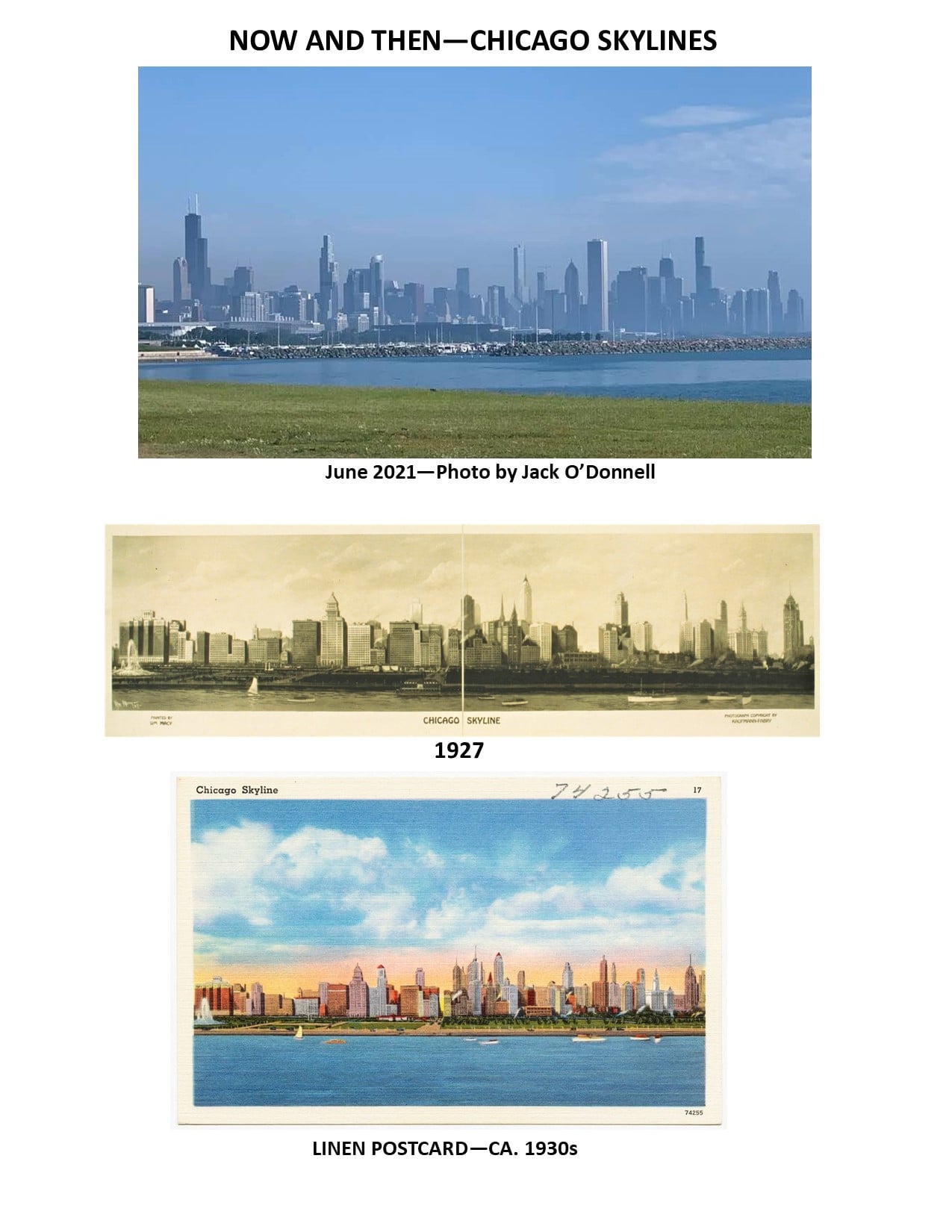
June 2021
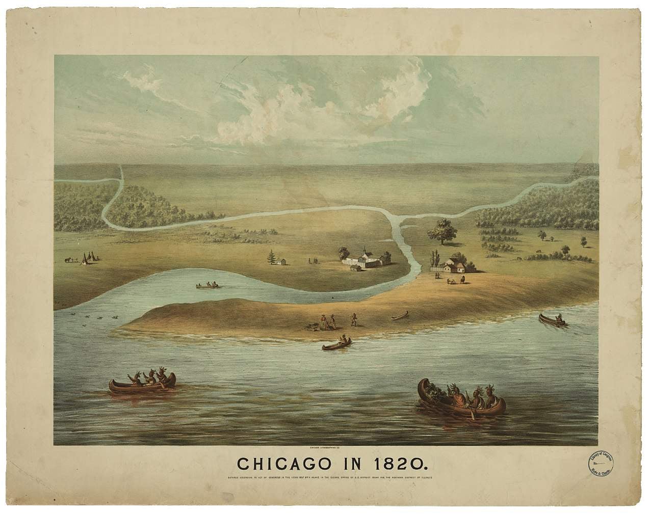
Thank you to Jack ODonnell for the wonderful picture of today's Chicago timeline.
Native Americans and the Blue Island Ridge – Part 3Native Americans and the Chicago area
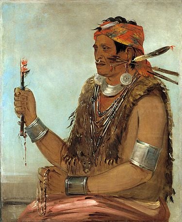
The greater Chicago area includes ancestral lands of 25 to 30 distinct Native American groups. By the time the Native Americans gave up the land via treaty with the U.S. Government and left the area in 1833-35, the predominant group living here were the Potawatomi people.
The Field Museum of Natural History has a vast collection on the Native peoples of North America and, since 2018, has been in the process of transforming the Native North American Hall.
The Field Museum issued a Land Acknowledgement Statement which reads:
We acknowledge that the Field Museum resides within the traditional homelands of many Indigenous nations:
• Hoocąk (Winnebago/Ho’Chunk), Jiwere (Otoe), Nutachi (Missouria), and Baxoje (Iowas)
• Kiash Matchitiwuk (Menominee)
• Meshkwahkîha (Meskwaki)
• Asâkîwaki (Sauk)
• Myaamiaki (Miami), Waayaahtanwaki (Wea), and Peeyankihšiaki (Piankashaw)
• Kiikaapoi (Kickapoo)
• Inoka (Illini Confederacy)
• Anishinaabeg (Ojibwe), Odawak (Odawa), and Bodéwadmik (Potawatomi)
Archeologists divide Native American history into eras or “traditions” and these eras are further broken down into more exact time periods and cultures. Very little is known about the earliest Indigenous Peoples who lived on the land dating back 3,000 years ago and before. Information becomes more available with the Woodland Tradition from 3,000 to 1,100 years ago, and the Mississippian Tradition which began about 1,100 years ago. More on these eras and Native American life during these times will be in future posts.
The term “confederacy” appears for some Native American groups. A confederacy is a union of sovereign groups that come together for common action. The Illini or Illinois Confederacy listed above was made up of a dozen tribes ranging east and south from Lake Michigan. Most of the Illini groups were destroyed by diseases introduced by the Europeans, or through war with other tribes. Their descendants are found today as part of the Peoria Tribe of Miami, Oklahoma.
The last group listed above is the Ojibwe, Odawa, and Potawatomi. These groups make up the Three Fires Confederacy or the Council of Three Fires. This is a long-standing alliance dating back for over a thousand years, that has a complex structure and operating system. The three tribes in this alliance are listed in a specific order – the Ojibwa or Chippewa are the “Older Brother,” the Keepers of Medicine. The Odawa or Ottawa are the “Middle Brother,” the Keepers of Trade. The Potawatomi are the “Younger Brother,” the Keepers of the Fire.
Only the Potawatomi actually lived in the Chicago area in any number, but as an alliance they all signed the treaty that resulted in Native Americans leaving the area in the 1830s. In 1830, there were forty Potawatomi communities in northern Illinois and thirty-six in northeast Indiana, with a total population over 6,000.
Many Land Acknowledgement Statements (LAS) in the Chicago area make reference to the Council of Three Fires. For example, the LAS for the Forest Preserves of Cook County reads: “The Forest Preserves of Cook County acknowledges that we are on the ancestral homelands of the Council of Three Fires—the Ojibwa, Ottawa and Potawatomi tribes—and a place of trade with many other tribes, including the Ho-Chunk, Miami, Menominee, Sauk and Meskwaki.”
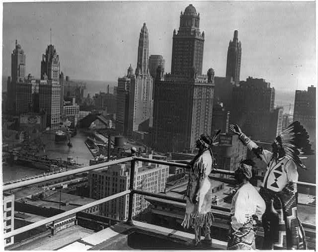
Photo: “Princess O-Me-Me, a Chippewa; Sun Road, A Pueblo; and Chief Whirling Thunder, a Winnebago, looking over Chicago's skyline from the roof of the Hotel Sherman.” October 3, 1929. From the Library of Congress.
The Chippewa and Winnebago tribes had ancestral land in the Chicago area. The Pueblo Indians were mostly in the southwest area, Arizona and New Mexico.
Next: More on Native Americans and the Chicago area – Fort Dearborn, treaties
Native Americans and the Blue Island Ridge – Part 2Native Americans and the United States
The United States of America is built upon land that was a vast network of homelands to many different groups of Indigenous Peoples before the European explorers “discovered” this “New World” – new to them, that is. Although the origin and timing of the arrival of the first humans on this landmass continue to be studied and debated, the Native American presence dates back at least 15,000 years.
Native Americans are referred to by several different terms – American Indians, First Americans, Indigenous Americans. In a 1995 U.S. Census Bureau survey, a plurality of this group said they prefer American Indian. The term “Indian” is often used in their organizations, such as the American Indian Center of Chicago, located on the north side of the city. These RHS posts will use the terms interchangeably.
There is no single Native American culture, language, or lifestyle – there were many different groups here when the Europeans arrived. Today, the U.S. government recognizes 574 tribes living in the forty-eight contiguous states and Alaska. “Native Hawaiian and Other Pacific Islander” is a separate group. About half of the people who make up the 574 tribes are associated with reservations.
The 574 number is not historically determined or permanently fixed. Groups may petition to be acknowledged as an official tribe. Right now, eleven groups are going through the petitioning process. Closest to Chicago is the Grand River Bands of Ottawa Indians in Michigan.
Researching American Indian history presents certain challenges. For most Native American groups, the traditional means of transmitting and understanding history has been through the oral tradition. Stories and history were and are verbally passed down from generation to generation. The emphasis is on identity, relationships, and interactions, including with the spirit world. History was not recorded as a chronological sequence of dates and events.
Much of the history of Native Americans that is available has been amassed primarily by researchers and academicians of European descent, and filtered through their viewpoints. They present and interpret what they consider important about Native American history, not what Native Americans consider important about their own history. The Native American viewpoint is every bit as important as the viewpoint of the people who came later.
In developing these posts, RHS is looking for resources that cover history from the Native Americans’ perspective. This is a learning experience for all of us.
The arrival of the European explorers, missionaries, traders, and settlers obviously had a profound effect upon the Native Americans, forever altering their ways of life, cultures, and the relationships between tribes.
Most Native Americans died from diseases introduced by the Europeans, to which they had no natural immunities. Smallpox, measles, influenza, cholera, etc., resulted in the deaths of 90% of Native Americans.
Native Americans inevitably became involved in conflicts and wars, primarily over land. A major reason conflicts with the European settlers arose was because the settlers were clearing land for farms, destroying the lands the Native Americans depended upon for hunting and gathering food. Settlers also destroyed Indian burial sites and other locations sacred to the local Native Americans.
The European settlers often used religion as their justification for the subjugation of native peoples – it was ordained by God that they should dominate the natives, convert them to Christianity, take their land, and force them to assimilate – or perish. More on this will be covered in future posts.
Native Americans became involved in wars between European countries fought on Native American lands. Some major conflicts included the French and Indian War, 1763; the American Revolution, 1776; the War of 1812; and the Black Hawk War, 1832. After this last war, Native Americans left the Chicago area.
With each encounter, no matter what side they were on, the Native Americans were negatively impacted. They were left out of peace negotiations and driven from more and more of their ancestral lands. The winning side often retaliated against the Native Americans who sided with the enemy.
The Second Continental Congress of 1775, before the American Revolution and the establishment of the U.S., created a Committee on Indian Affairs, headed by Benjamin Franklin. The role was to establish treaties with tribes so the tribes would be neutral in the independence movement.
The U.S. Constitution includes as Article I, Section 8, a description of Congress's role with Indian affairs: "To regulate commerce with foreign nations, and among the several States, and with the Indian tribes."
In 1789, Indian Affairs was moved to the newly formed U.S. War Department. The Bureau of Indian Affairs (BIA), a Federal agency, was established in 1824, under President James Monroe. The BIA became part of the Department of the Interior (DOI) when DOI was formed in 1849. During these earliest years, efforts were concentrated on overseeing the fur trade with the Indians, and removing them from their ancestral lands by treaty or force in order to aid settlement, and relocating them to land usually further west.
Next Post: Native Americans and the Chicago Area
Native Americans and the Blue Island Ridge – Part 1Introduction
This series on Native Americans and the Ridge evolved from research for a background paper being prepared to assist local organizations in developing “land acknowledgment statements.”
It became evident that what started as a “history paper” could not be quickly or easily addressed. The history of Native Americans is very complex and, like all history, not static – viewpoints and “facts” are always changing as new information is found and old information is reinterpreted.
More importantly, Native Americans are not just part of the past – they are very much part of the present and future of this country.
This series will begin the exploration of some topics related to Native Americans in this area and readers are encouraged to seek out additional information and resources.
In recent years, governments, universities, cultural organizations, churches, and other institutions have begun recognizing the Native American heritage of the land through land acknowledgment statements (LAS). These are formal declarations put out in writing that note the organization is located on land that was once the ancestral grounds of Native Americans.
These statements first started being used in Canada in 2015. They are often read aloud at the beginning of an event. In Canada, they are regularly included at events ranging from parliament sessions to ballet performances to National Hockey League games.
Last year, Chicago-area groups began issuing land acknowledgment statements.
The Field Museum of Natural History, not surprisingly, has a website page devoted to the topic. We will make references to that in our posts.
The Forest Preserves of Cook County also has issued a LAS, which includes the northern tip of the Ridge, located in the Dan Ryan Forest Preserve.
A typical LAS begins, “We acknowledge that the [name of organization] resides within the traditional homelands of [name of Indigenous Peoples].” This is usually followed by additional comments supportive of Native Americans.
Land acknowledgment statements have their issues, of course. One logical question after hearing or reading such a statement is what is the relevance to today? How do we make this statement something useful and meaningful to today’s Native Americans?
In April, RHS was contacted by a representative of the Beverly Unitarian Church who was working on a LAS for that organization. Discussions and research led to a Zoom meeting with John Low, Ph.D., J.D., a professor at Ohio State University, who is an enrolled citizen of the Pokagon Band of Potawatomi Indians.
In discussing how to make a LAS meaningful, Dr. Low commented that each organization has to look at its situation and determine how best to do that. We agreed that for a small, local organization like RHS, the obvious role is one of education through written materials, programming, etc., to help the community understand the heritage of Native Americans in this area. We will attempt to do that.
Next post: Part 2: Native Americans and the United States
RHS is using Memorial Day to announce our next feature series, which will be on the Native American heritage of the Ridge.
Right now, organizations, universities, churches, businesses, etc., are developing “Land Acknowledgement Statements.” These are declarations that recognize that the land we are using today was the ancestral homelands of Indigenous Peoples who lived here for at least 13,000 years before the European settlers came.
To help with land acknowledgment statements for the Blue Island Ridge, a background paper on the Native American presence on the Ridge has been evolving through research efforts at RHS. This is a fascinating and complex topic. Information will be shared through the Facebook page and other RHS communications and programs as time goes on.
Why start with Memorial Day? For two reasons. First, Native Americans have a long and unrecognized history of service in the U.S. Armed Forces. For many people, the only glimpse they have had into this part of history was through the 2002 movie “Windtalkers” which was based on the real story of Navajo code talkers during World War II. The Navajo language was used to direct artillery operations in the field, and the “code” was never broken by the enemy.
Native Americans serve in the U.S. Armed Forces at a higher rate than any other group. Since the 9/11 terrorist bombing, 19% of Native American men and women have served, compared to an average of 14% for all other groups. This is consistent among the 573 federally recognized Native American tribes.
In interviews, they cite their reasons for enlisting. Of course, the economic factor cannot be ignored – pay, benefits, opportunities. But for many, there is a family heritage, and the time-honored warrior culture of protecting their land, their home, their family, their ideals. Native Americans are not just part of the United States’ past, they are very much the present and future, also.
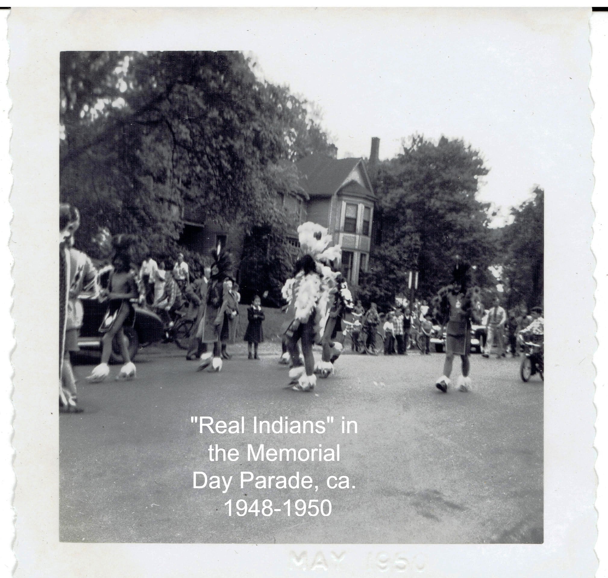
Second, in exploring the history of the Memorial Day Parade, which has gone on in this community for over 100 years even though canceled for 2020-21 because of the COVID pandemic, we came across an intriguing picture, from the scrapbook of the RHS President Elaine Spencer.
Elaine was a student at Morgan Park High School in the late 1940s. She participated in the Memorial Day Parade and a family member took photos. In her scrapbook is a picture from 1948-50 which is labeled “Real Indians” in the parade (shown here).
From all appearances, these do look like Native Americans in ceremonial dress and we continue to investigate their background, through the American Indian Center of Chicago, which opened in 1953, and other means.
At the time, there were only about a thousand Native Americans reported living in Chicago. Right after this, in the 1950s-1960s, there was a government relocation program to move Native Americans to urban areas, and thousands more came here, but that had not happened yet.
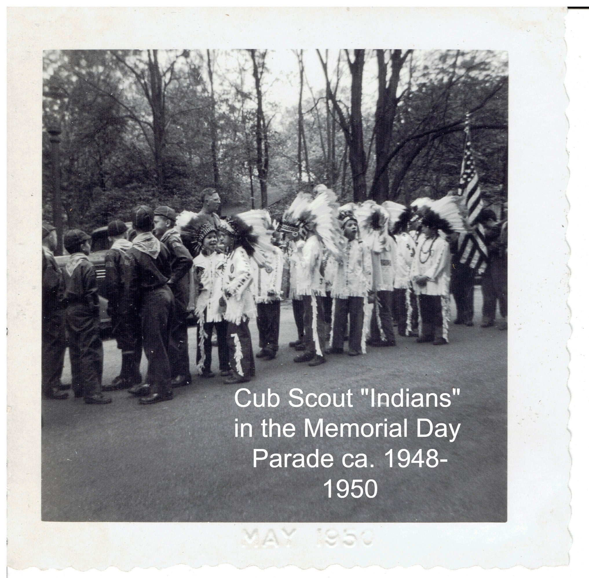
It was not unusual for Scouts and other groups, including adults, to take “Indian” names and dress in costumes, and there were marchers reflecting that also. Their look is very different from the “Real Indians.” A picture of a Cub Scout group dressed in their version of "Indian" attire is also shown here.
Stay tuned for the series on Native Americans and the Blue Island Ridge.
National Jewish American Heritage Month
May 2021
May is a busy month for recognitions – nurses, teachers, and police are all honored during this month.
May is also National Jewish American Heritage Month.
The Ridge was home to a thriving Jewish American community and there was once a Jewish synagogue in North Beverly.
The following is from the RHS newsletter, adapted from “Beth Torah: The Congregation That Held Services in a Castle,” by Errol Magidson, published in Chicago Jewish History, Vol. 38, No. 4, Fall 2014, a publication of the Chicago Jewish Historical Society.
“In 1953, Jews living on the far southwest side of Chicago and nearby suburbs established a Reform congregation which they named Beth Torah, or Temple of Instruction. All but one of the officers lived in the Beverly/Morgan Park community. In their early years, they held services at the [Beverly Unitarian Church in] Givins Beverly Castle, Trinity Methodist Church, and Bethany Union Church, and in members’ homes. Although small, the congregation was active with classes, a youth group, membership and fund drives, and social events like hay rides and fashion shows.
“A major goal of the congregation was to have its own synagogue. Funds were raised, land was purchased at 93rd Street and Vanderpoel Avenue, and a building was constructed.
"Beth Torah Synagogue opened in October 1961. But by 1974, due to an aging membership and a decline in the number of Jewish families in the Beverly area, a number of the Beth Torah congregants opted to affiliate with another congregation in Olympia Fields.
“The Beth Torah Synagogue was purchased by the Chicago Board of Education in 1974 and used for classrooms for a few years. Eventually, the building was torn down but the foundation still remains.”
The weed-choked vacant lot at 93rd Street and Vanderpoel Avenue is all that is left of the synagogue – even vacant lots have interesting histories! There are, of course, Jewish residents on the Ridge, active participants in neighborhood affairs, members of the ever-diverse population that calls this community home.
With thanks to Errol Magidson.
Ridge Historical Society
National Police Week: The History of the Morgan Park Police Station – Part 3
By Carol Flynn
This is the timeline for the Morgan Park police station:
1914 – The Village of Morgan Park annexes to Chicago; a Morgan Park police station is established as part of the Chicago Police Department, incorporating the four officers previously employed by the Village.
1918 – Morgan Park station is discontinued; a small substation continues in a barn.
1928 – A new station is planned but never built.
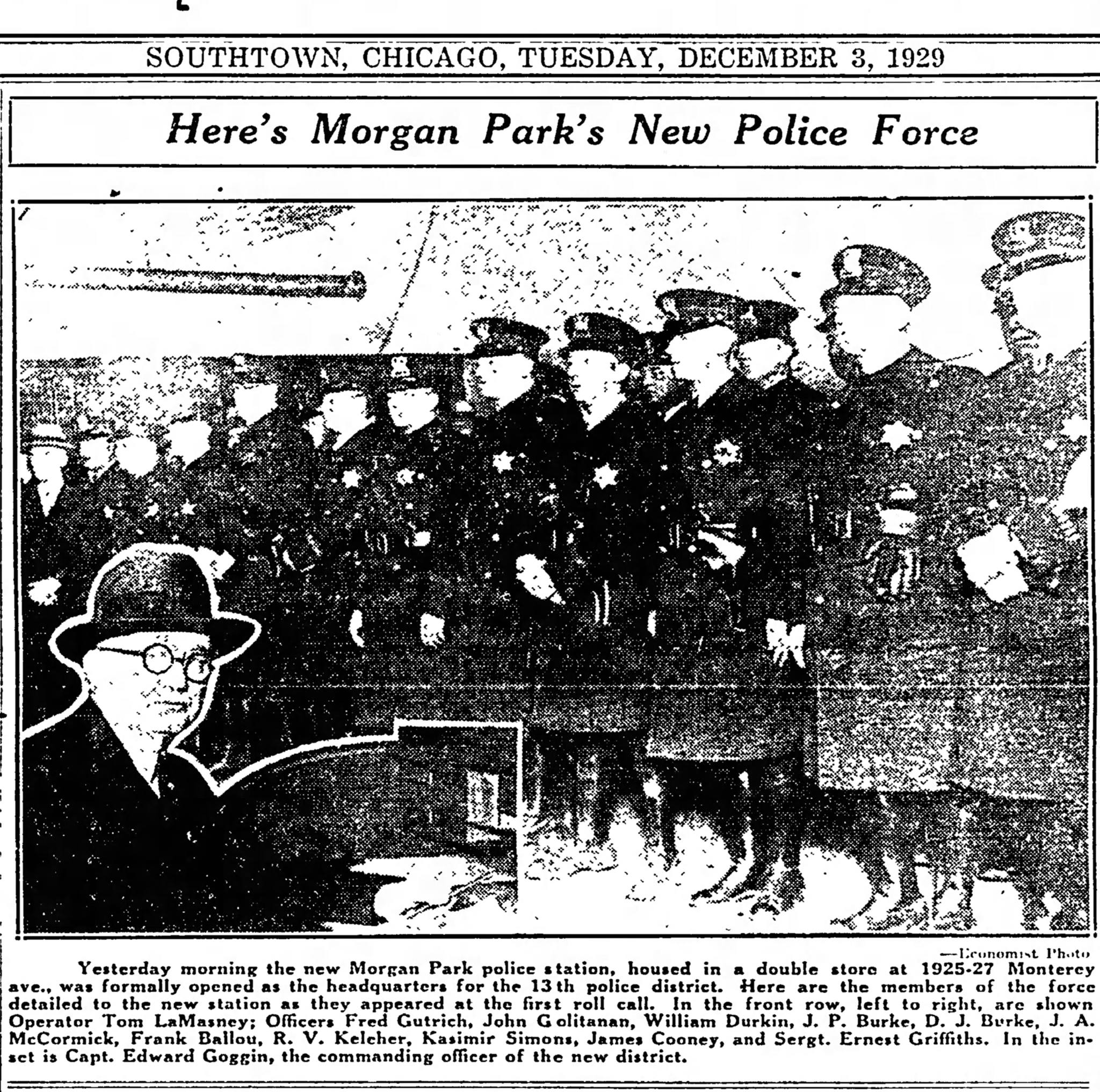
1929 – A new Morgan Park station opens in a storefront at 1925-27 Monterey Avenue.
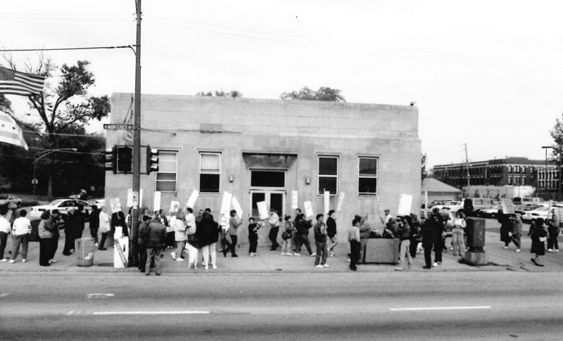
1936 – A new station is built at 1830 W. Monterrey Ave.
1961 – The Morgan Park police station is closed once again.
1975 – The Morgan Park police station is reopened at 1830 Monterey Ave.
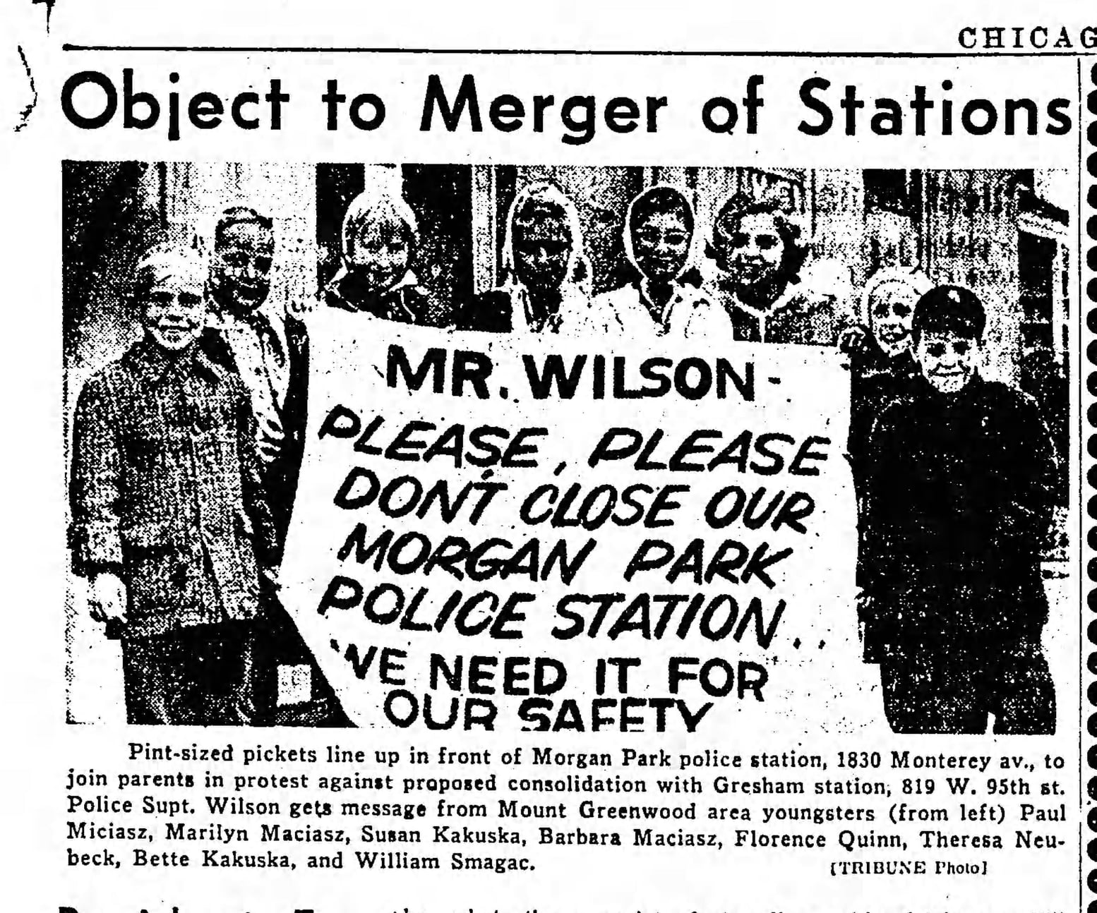
1983 – The City of Chicago announces plans to close the Morgan Park police station again but the community prevails in keeping the station open.
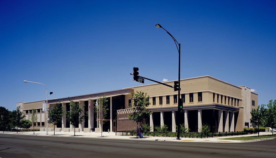
2004 – The current 22nd District Police Station at 1930 W. Monterey opens.
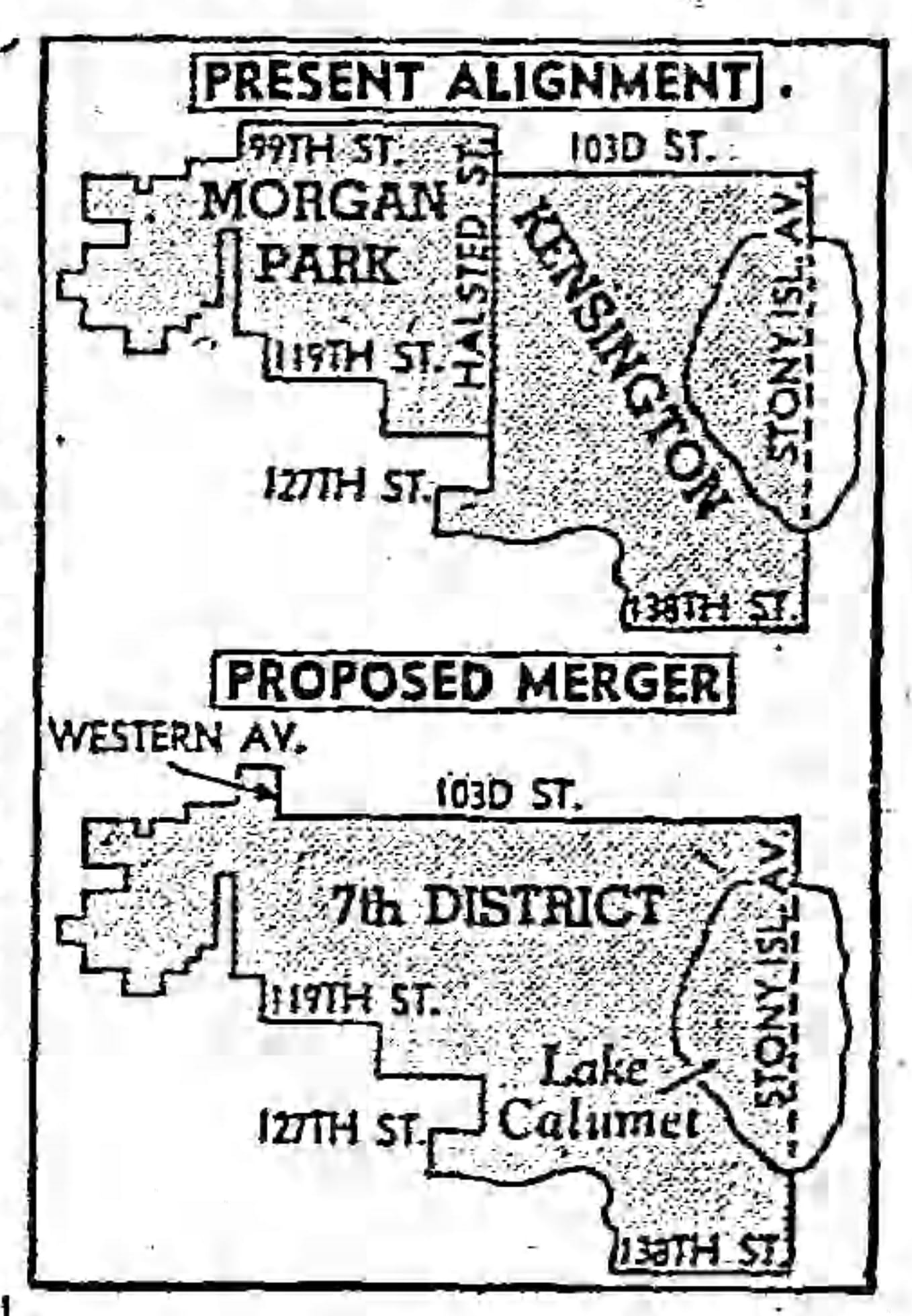
Throughout its history, the City of Chicago has gone back and forth on the philosophy of a centralized versus a decentralized police station. “Centralized” calls for command and decision-making coming from fewer people at the top levels of the hierarchy, resulting in fewer facilities to maintain with fewer administrative staff. The belief is that less budget spent on administrative costs frees up more for actual officers out on the street. When the pendulum swung toward centralized command, Morgan Park lost its police station and had to rely on services from either Kensington or Gresham.
When the pendulum swung toward “decentralized” policing, that is, command and decision-making are focused in the communities where the services occur, Morgan Park got its police station back. And of course, this being Chicago, the role politics played in deciding where police stations were established – or removed from – can never be discounted.
In 1960, it was announced that the City of Chicago was reorganizing the police department again, consolidating districts and closing some stations. Just as in 1918, the rationale was that less money spent on administration would allow for more police on the street.
The proposal included combining the 12th and 13th districts and eliminating the Morgan Park station at 1830 West Monterey Avenue. The community, led by the Beverly Area Planning Association (BAPA), strongly opposed this. But appeals to the mayor, city council, and police department went unheard, and the station closed at midnight, December 18, 1961. The Chicago Board of Education took over the old police station.
In the spring of 1975, it was announced that the Morgan Park police station would reopen in the building on Monterey. The current Police Superintendent, James M. Rochford, supported decentralized policing efforts. In the past, the main reason the districts were aligned the way they were was actually due to the technology at the time – the coordination of the telephone exchanges system and the police radio zones. The telephone system was due to be computerized, which would end this system and allow the police department to set boundaries based on community needs rather than telephone lines.
The 22nd Police District opened its doors in March 1975 in the existing building at 1830 Monterey, necessitating the Board of Education to vacate the premises.
The boundaries of the district were the Dan Ryan Woods on the north; the Chicago, Western, and Indiana railroad tracks on the east; and the city limits on the south and west.
In 1983, it was once again proposed that Morgan Park be one of three stations to close to reduce administrative costs for the city. The community fiercely fought the closing and it did not happen.
In 2000, it was announced that as part of a continuing program to replace aging and outmoded police stations citywide, a new station would be built at 111th and Esmond Streets. The city used its power of eminent domain to acquire some of the property, forcing the removal of some occupied homes. The Edna White Community Garden had to relocate to the land vacated across the street when the old building was torn down.
The new facility opened at 1900 West Monterey Avenue in the summer of 2004. Where the old station had no lockers, no private rooms for discussions, no holding cells, no parking lot, and limited technology, the new station not only had lockers, it included a fitness room. It had a community room and private meeting rooms, a lockup, two parking lots, and, most important, high-tech equipment. It was also built to be “green,” using recycled materials and energy-efficient design elements.
The 22nd District has been operating out of this building for seventeen years.
Ridge Historical Society
National Police Week: The History of the Morgan Park Police Station – Part 2
By Carol Flynn
The Morgan Park police station was closed in 1918, four years after it was established when the village annexed to the City of Chicago. Morgan Park was now serviced by District 8 – Precinct 10, referred to as the Kensington station, located at 200 East 115th Street. The District 9 – Precinct 12 station at 8501 South Green Street, referred to as the Gresham station, was the other station that could service the area.
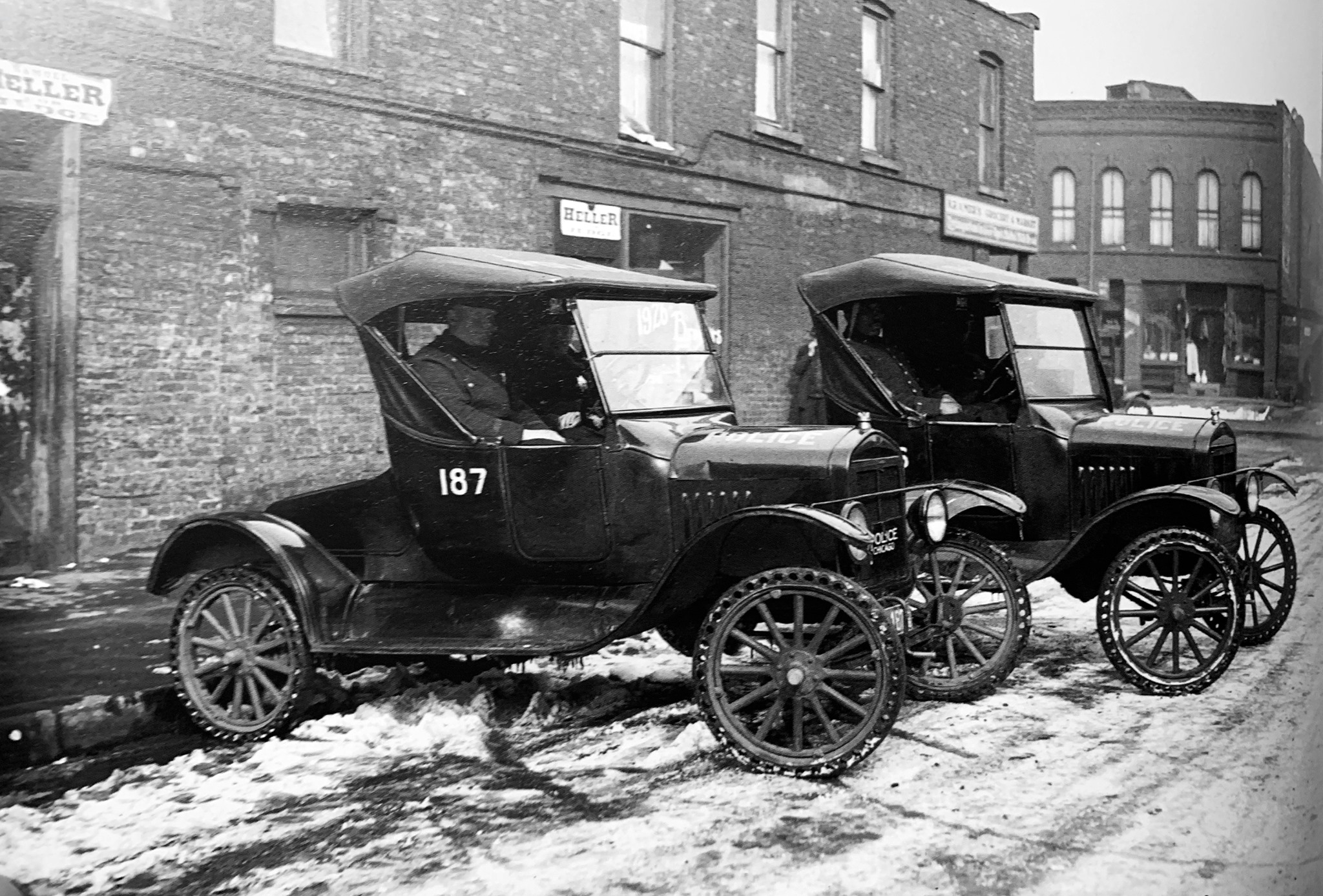
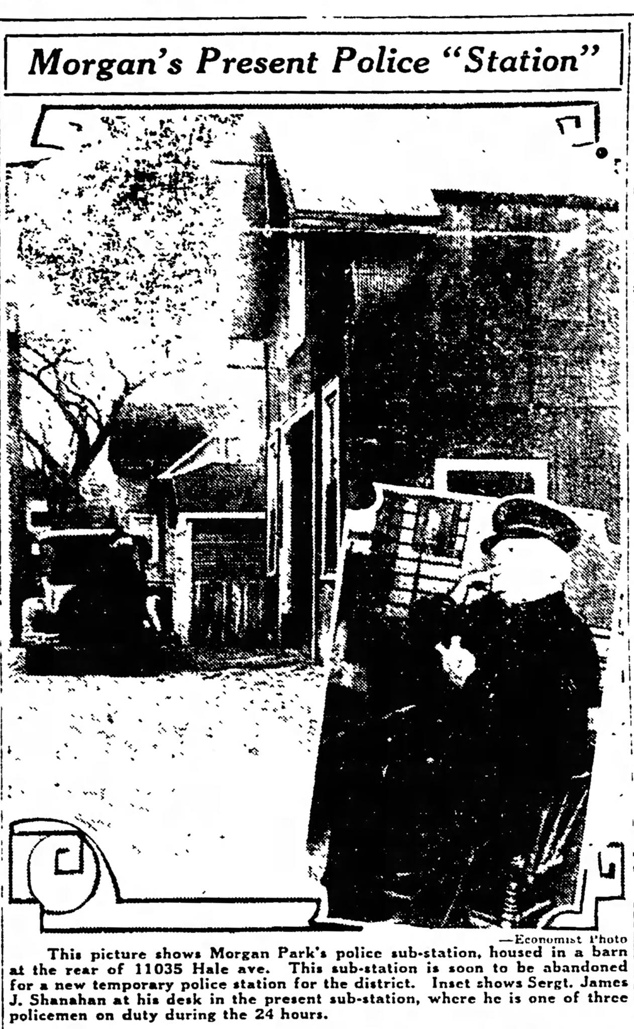
A frame building at 11033 South Hale Avenue was used as a small sub-station after 1918, with a few officers assigned there. The building was behind the storefront originally used as the town hall and was described in the papers as the “old barn in the alley.” One “flivver” squad operated out of the building and other police autos were stored there.
In 1925, the Morgan Park community requested that their area be transferred to the Gresham station as it would be easier and closer. It was also requested that the substation in the barn be moved to the storefront on the property, the old town hall. Concern was expressed it was inconvenient and inappropriate for women to have to walk down a dark alley to get help, especially at night. The transfer to Gresham happened in July 1926, but the relocation of the sub-station did not happen.
By 1927 the Morgan Park community was seriously petitioning the city to establish a new police station there. A series of home robberies and “peeping Toms” at the “scantily protected homes of Beverly Hills” and purse snatches along Vincennes Avenue had led to fear and concern. It was felt it took too long for a response from Kensington or Gresham.
Commissioner of Police Michael Hughes gave assurances that the department would try for a new station and personnel, but this would depend on securing the funding from the city. Hughes reportedly had already asked the city for 8,000 additional men.
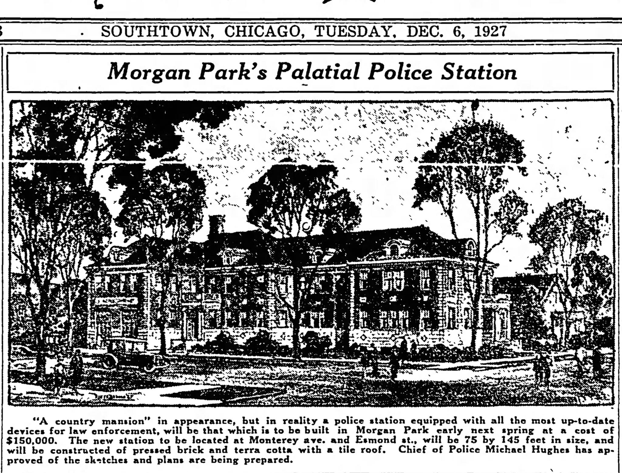
Later that year, it was announced that a state-of-the-art police station would be built at Monterey Avenue and Esmond Street in Morgan Park. The plans showed a brick building with professional landscaping that would include a courtroom, holding cells with showers, a dormitory, a gymnasium, and a garage. Designed by city architect Argyle E. Robinson to fit in with the architecture in the area, Hughes described it as “a beautiful building that would look more like a country mansion than a police station.”
Land was purchased at the northeast corner of Monterey Avenue and Esmond Street for the new station. In early 1928, it was reported that the plans for the new station had been approved by all necessary parties; the money had been set aside from a recent bond issue; bids were received and ready to be reviewed; and the contract would be awarded in time for the new station to be open by October.
This new building was never built. Instead, the funds were diverted to completing the central police station at 11th and State Streets.
Disappointed, in 1929, the citizens of Morgan Park again went back to the Commissioner of Police, now William Russell.
The city agreed to rent a double storefront at 1925-27 Monterey Avenue to use as a new station. The location was considered temporary until the funds could be found to build a new station. The facility was remodeled, telephone lines were installed, and the new 13th District opened on December 2, 1929. The day sergeant from the alley substation became the day sergeant in the new facility.
The boundaries of the new district were Halsted Avenue, 99th Street, and the city limits to the south and west. Mount Greenwood had annexed to the city in 1927 and was included in the new district. There were no holding cells or garage at the facility, so prisoners and wagon calls still had to be handled out of Gresham or Kensington.
The Ridge community welcomed the new police staff with a parade, entertainment, speeches, and a luncheon at Morgan Park High School. Every civic group in the community was represented at the event. The entertainment was provided by a vocalist, a trio of police singers, and the high school band.
In January 1936, it was announced that the city had received over $11 million in grants and loans from the Public Works Administration (PWA). This was a federal program during the Great Depression to supply jobs to unemployed men for construction projects. PWA funds could be used for 45% of the cost of a public building. City architect Paul Gerhardt designed a “standard” police station to be built in several locations, including Morgan Park.
A new cement art deco-style station was finally built in 1936 at 1830 West Monterey Avenue. This one included holding cells and a garage. Morgan Park finally once again had a completely functional police station.
And then in 1961, the unthinkable again happened – the City of Chicago closed the Morgan Park police station.
Next post: Once again Morgan Park seeks to reestablish its police station.